File:GF-Map-Page-2 (cropped).jpg
Jump to navigation
Jump to search

Size of this preview: 663 × 599 pixels. Other resolutions: 266 × 240 pixels | 531 × 480 pixels | 850 × 768 pixels | 1,133 × 1,024 pixels | 2,266 × 2,048 pixels | 2,730 × 2,467 pixels.
Original file (2,730 × 2,467 pixels, file size: 489 KB, MIME type: image/jpeg)
Captions
Captions
Add a one-line explanation of what this file represents
Summary[edit]
| Description |
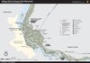
English: Map of trails in the Great Falls area, from NPS. |
| Source | http://www.nps.gov/choh/planyourvisit/upload/GF-Map-Page-2.pdf |
| Author | [1] US National Park Service |
| Other versions |
.jpg&action=edit§ion=1)
Licensing[edit]
.jpg&action=edit§ion=2)
| This image or media file contains material based on a work of a National Park Service employee, created as part of that person's official duties. As a work of the U.S. federal government, such work is in the public domain in the United States. See the NPS website and NPS copyright policy for more information. |
File history
Click on a date/time to view the file as it appeared at that time.
| Date/Time | Thumbnail | Dimensions | User | Comment | |
|---|---|---|---|---|---|
| current | 11:43, 29 June 2020 | | 2,730 × 2,467 (489 KB) | Dcflyer (talk | contribs) | File:GF-Map-Page-2.pdf cropped 44 % horizontally, 28 % vertically using CropTool with precise mode. |
You cannot overwrite this file.
File usage on Commons
The following 4 pages use this file:
File usage on other wikis
The following other wikis use this file:
- Usage on www.wikidata.org
.jpg&oldid=691069778)