File:Franklin's lost expedition map ru.png
Jump to navigation
Jump to search
No higher resolution available.
Franklin's_lost_expedition_map_ru.png (602 × 522 pixels, file size: 42 KB, MIME type: image/png)
Captions
Captions
Add a one-line explanation of what this file represents
| Description |
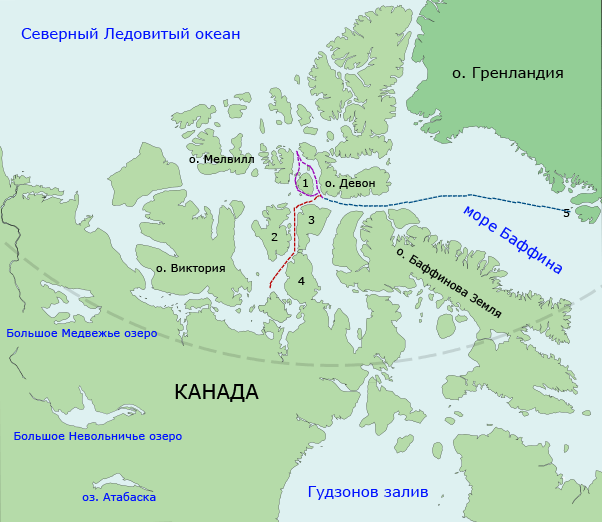
Русский: Предполагаемый маршрут кораблей «Эребус» и «Террор» в ходе арктической экспедиции Джона Франклина (1845-1848).
Путь из залива Диско (5) к острову Бичи, 1845 Обход вокруг острова Корнуоллис (1), 1845 Путь от острова Бичи через пролив Роберта Пила между островом принца Уэльского (2), островом Сомерсет (3) и полуостровом Бутия (4) к острову Кинг-Уильям, 1846 English: Map of the probable routes taken by Erebus and Terror during Franklin's lost expedition. Disko Bay (5) to Beechey Island, in 1845 Around Cornwallis Island (1), in 1845 Beechey Island down Peel Sound between Prince of Wales Island (2) and Somerset Island (3) and the Boothia Peninsula (4) to near King William Island in 1846 |
| Date | (UTC) |
| Source | |
| Author |
|
| This is a retouched picture, which means that it has been digitally altered from its original version. Modifications: Translated to Russian; outline edits; route redrawn. The original can be viewed here: Franklin's lost expedition map.png:
|
I, the copyright holder of this work, hereby publish it under the following licenses:
This file is licensed under the Creative Commons Attribution-Share Alike 3.0 Unported license.
- You are free:
- to share – to copy, distribute and transmit the work
- to remix – to adapt the work
- Under the following conditions:
- attribution – You must give appropriate credit, provide a link to the license, and indicate if changes were made. You may do so in any reasonable manner, but not in any way that suggests the licensor endorses you or your use.
- share alike – If you remix, transform, or build upon the material, you must distribute your contributions under the same or compatible license as the original.

|
Permission is granted to copy, distribute and/or modify this document under the terms of the GNU Free Documentation License, Version 1.2 or any later version published by the Free Software Foundation; with no Invariant Sections, no Front-Cover Texts, and no Back-Cover Texts. A copy of the license is included in the section entitled GNU Free Documentation License. |
This image is in the public domain because it contains materials that originally came from the United States Central Intelligence Agency's World Factbook.
|
 |
You may select the license of your choice.
Original upload log[edit]
This image is a derivative work of the following images:
- File:Franklin's_lost_expedition_map.png licensed with Cc-by-sa-3.0, GFDL, PD-USGov-CIA-WF
- 2009-06-06T14:52:01Z Like tears in rain 602x520 (124302 Bytes) Trying to remove border
- 2008-07-24T00:12:01Z Finetooth 668x536 (117098 Bytes) {{Information |Description={{en|1={{en|Map of the probable routes taken by ''Erebus'' and ''Terror'' during Franklin's lost expedition. {{legend|blue|Disko Bay (5) to Beechey Island, in 1845}} {{legend|purple|Around Cornwalli
Uploaded with derivativeFX
File history
Click on a date/time to view the file as it appeared at that time.
| Date/Time | Thumbnail | Dimensions | User | Comment | |
|---|---|---|---|---|---|
| current | 18:42, 27 April 2011 | | 602 × 522 (42 KB) | Dangaard (talk | contribs) | {{Information |Description={{en|Предполагаемый маршрут кораблей «Эребус» и «Террор» в ходе арктической экспедиции Джона Франклина (1845-1848). {{legend|blue|Путь и |
You cannot overwrite this file.
File usage on Commons
There are no pages that use this file.
File usage on other wikis
The following other wikis use this file:
- Usage on ru.wikipedia.org