File:Fall foliage in the Great Lakes area ESA222234.tiff
Original file (2,272 × 2,272 pixels, file size: 12.53 MB, MIME type: image/tiff)
Captions
Captions
Summary[edit]
| Description |
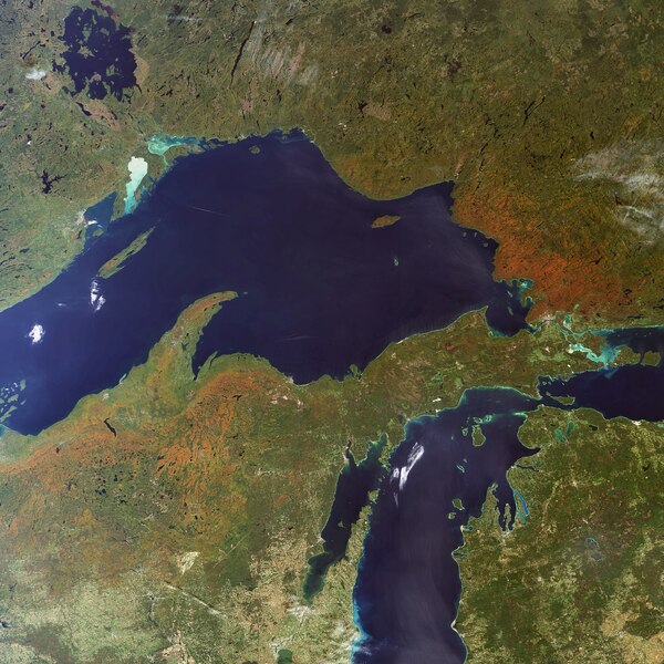
English: This Envisat image highlights the orange autumn foliage of the forested areas in the basin of Lake Superior (image centre), one of the five Great Lakes located in the heart of eastern North America.
Covering a total area of 244 000 km² and containing about 23 000 km³ of water, the Great Lakes form the largest connected area of fresh, surface water on Earth – roughly 18 percent of the world supply. The only place where more fresh water is contained is in the polar ice caps. The five Great Lakes are Superior, Michigan (visible on the left side of lower left corner), Huron (visible on right side of lower left corner), Erie and Ontario. Of these, Lake Michigan is the only one not to straddle the U.S.-Canada border, as it is located entirely within the U.S.. Lakes Michigan and Huron are hydrologically inseparable. Lake Superior is the largest by volume. According to the U.S. Environmental Protection Agency (EPA), Superior could contain all the other Great Lakes and three more Lake Eries. Lake Michigan is the second largest by volume followed by Lake Huron. Lake Ontario, although smaller in area than Erie, is the second smallest by volume. Lake Erie is the smallest by volume. The sheer size of the lakes’ surface area makes them vulnerable to direct atmospheric pollutants that arrive on their surface via rain, snow or dust. Because the outflows from the lakes are less than 1 percent per year, pollutants that enter the waters are retained for long periods. Because of its size, Superior has a retention time -- a measure based on the volume of water in the lake and the mean rate of outflow -- of 191 years, according to EPA. Lake Erie has the shortest retention time of the lakes – 2.6 years. Some of the approximately 35 000 islands located within the Great Lakes are visible in the image. The islands are home to several species of plants endemic solely to Great Lakes islands. This image was acquired by Envisat's Medium Resolution Imaging Spectrometer (MERIS) instrument on 23 September 2007, working in Full Resolution mode to provide a spatial resolution of 300 metres. |
| Date | |
| Source | http://www.esa.int/spaceinimages/Images/2007/10/Fall_foliage_in_the_Great_Lakes_area |
| Author | European Space Agency |
| Permission (Reusing this file) |
ESA,CC BY-SA 3.0 IGO |
| Other versions |
|
| Title | Fall foliage in the Great Lakes area |
| Set | Earth observation image of the week |
| System | MERIS |
| Mission | Envisat |
| Location | Canada |
| Activity | Observing the Earth |
| Keywords | Water (fresh); Lakes; Satellite image |

Licensing[edit]
- You are free:
- to share – to copy, distribute and transmit the work
- to remix – to adapt the work
- Under the following conditions:
- attribution – You must give appropriate credit, provide a link to the license, and indicate if changes were made. You may do so in any reasonable manner, but not in any way that suggests the licensor endorses you or your use.
- share alike – If you remix, transform, or build upon the material, you must distribute your contributions under the same or compatible license as the original.
File history
Click on a date/time to view the file as it appeared at that time.
| Date/Time | Thumbnail | Dimensions | User | Comment | |
|---|---|---|---|---|---|
| current | 18:21, 24 May 2017 |  | 2,272 × 2,272 (12.53 MB) | Fæ (talk | contribs) | European Space Agency, Id 222234, http://www.esa.int/spaceinimages/Images/2007/10/Fall_foliage_in_the_Great_Lakes_area, User:Fæ/Project_list/ESA |
You cannot overwrite this file.
File usage on Commons
The following page uses this file: