File:Falk Oberdorf Wiehengebirge physisch.png
Jump to navigation
Jump to search

Size of this preview: 800 × 436 pixels. Other resolutions: 320 × 175 pixels | 640 × 349 pixels | 1,024 × 559 pixels | 1,547 × 844 pixels.
Original file (1,547 × 844 pixels, file size: 961 KB, MIME type: image/png)
Captions
Captions
Add a one-line explanation of what this file represents
Summary[edit]
| Description |
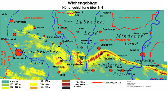
Deutsch: Physische Karte des Wiehengebirges zwischen Bramsche in Niedersachsen und Porta Westfalica in Nordrhein-Westfalen. |
| Date |
27 July 2008 (original upload date) |
| Source | Own work (Original text: selbst erstellt) |
| Author | Falk Oberdorf, Osterstr. 8, 32312 LK |
| Permission (Reusing this file) |
(FalkOberdorf 03:37, 27. Jul. 2008 (CEST)) |
| Object location | | View this and other nearby images on: OpenStreetMap |
|---|
Licensing[edit]
| I, the copyright holder of this work, release this work into the public domain. This applies worldwide. In some countries this may not be legally possible; if so: I grant anyone the right to use this work for any purpose, without any conditions, unless such conditions are required by law. |
Original upload log[edit]
The original description page was here. All following user names refer to de.wikipedia.
- 2008-07-27 01:37 FalkOberdorf 1547×844× (984087 bytes) {{Information |Beschreibung = Physische Karte des Wiehengebirges |Quelle = selbst erstellt |Urheber = Falk Oberdorf, Osterstr. 8, 32312 LK |Datum = 25.07.2008 |Genehmigung = ~~~~ |Andere Versionen = |Anmerkungen = }}

|
This geology image could be re-created using vector graphics as an SVG file. This has several advantages; see Commons:Media for cleanup for more information. If an SVG form of this image is available, please upload it and afterwards replace this template with
{{vector version available|new image name}}.
It is recommended to name the SVG file “Falk Oberdorf Wiehengebirge physisch.svg”—then the template Vector version available (or Vva) does not need the new image name parameter. |
File history
Click on a date/time to view the file as it appeared at that time.
| Date/Time | Thumbnail | Dimensions | User | Comment | |
|---|---|---|---|---|---|
| current | 15:38, 18 December 2008 | | 1,547 × 844 (961 KB) | TUBS (talk | contribs) | {{Information |Description={{de|Physische Karte des Wiehengebirges}} |Source=Transferred from [http://de.wikipedia.org de.wikipedia]<br/> (Original text : ''selbst erstellt'') |Date=2008-07-27 (original upload date)<br/> (Original text : ''25.07.2008'') | |
You cannot overwrite this file.
File usage on Commons
There are no pages that use this file.
File usage on other wikis
The following other wikis use this file:
- Usage on de.wikipedia.org
- Usage on de.wikivoyage.org
- Usage on fr.wikipedia.org
- Usage on nl.wikipedia.org
- Usage on no.wikipedia.org
- Usage on ro.wikipedia.org
- Usage on sv.wikipedia.org