File:European Neighbourhood Policy member map.svg
Jump to navigation
Jump to search

Size of this PNG preview of this SVG file: 524 × 491 pixels. Other resolutions: 256 × 240 pixels | 512 × 480 pixels | 820 × 768 pixels | 1,093 × 1,024 pixels | 2,186 × 2,048 pixels.
Original file (SVG file, nominally 524 × 491 pixels, file size: 589 KB)
Captions
Captions
Add a one-line explanation of what this file represents
| Description |
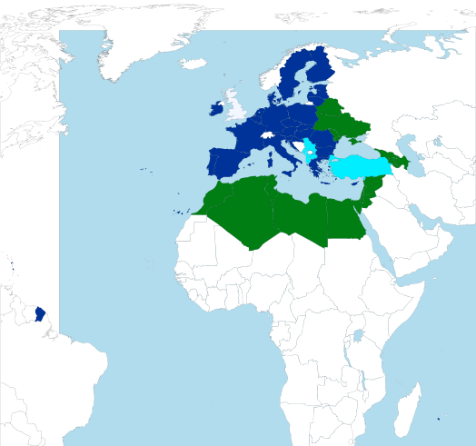
European Neighbourhood Policy / Europejska Polityka Sąsiedztwa / Europäische Nachbarschaftspolitik / Європейська політика сусідства / Европейская политика соседства / Եվրոպական Հարևանության Քաղաքականություն European Union Acceding state (None) Official candidates European Neighbourhood Policy
Map of world based on BlankMap-World6.svg |
| Date | (UTC) |
| Source | |
| Author |
|
| This is a retouched picture, which means that it has been digitally altered from its original version. Modifications: SVG-Version aus JPG-Bild erstellt. The original can be viewed here: BlankMap-World8.svg:
|
This file is licensed under the Creative Commons Attribution-Share Alike 3.0 Unported license.
- You are free:
- to share – to copy, distribute and transmit the work
- to remix – to adapt the work
- Under the following conditions:
- attribution – You must give appropriate credit, provide a link to the license, and indicate if changes were made. You may do so in any reasonable manner, but not in any way that suggests the licensor endorses you or your use.
- share alike – If you remix, transform, or build upon the material, you must distribute your contributions under the same or compatible license as the original.
Original upload log[edit]
This image is a derivative work of the following images:
- File:ENP.jpg licensed with Cc-by-sa-3.0-migrated, GFDL
- 2008-09-20T12:28:46Z Siekierki 587x566 (177292 Bytes) {{Information |Description= European Neighbourhood Policy / Europejska Polityka Sąsiedztwa / Europäische Nachbarschaftspolitik / Європейська політика сусідства / Европейская полит
- File:BlankMap-World8.svg licensed with PD-self
- 2008-02-20T05:12:19Z AMK1211 1410x715 (1181772 Bytes) {{Information |Description=Map of world based on BlankMap-World6.svg |Source=self-made |Date=2008-02-20 |Author= [[User:AMK1211|AMK1211]] |Permission=Public Domain |other_versions=BlankMap-World6.svg }}
Uploaded with derivativeFX
File history
Click on a date/time to view the file as it appeared at that time.
| Date/Time | Thumbnail | Dimensions | User | Comment | |
|---|---|---|---|---|---|
| current | 13:20, 12 March 2020 | | 524 × 491 (589 KB) | Kpfiwa (talk | contribs) | Brexit ab 01.02.2020 |
| 13:45, 17 December 2017 |  | 524 × 491 (574 KB) | Artemis Dread (talk | contribs) | Reverted to version as of 18:30, 16 March 2015 (UTC) | |
| 22:13, 9 June 2017 |  | 600 × 600 (967 KB) | Master Uegly (talk | contribs) | error fixed | |
| 21:36, 9 June 2017 |  | 600 × 600 (967 KB) | Master Uegly (talk | contribs) | depicted area changed - oversea départements and states far from Europe are actually not that important to show | |
| 18:30, 16 March 2015 |  | 524 × 491 (574 KB) | NordNordWest (talk | contribs) | upd Iceland | |
| 20:19, 6 February 2015 |  | 655 × 614 (683 KB) | Winnetou14 (talk | contribs) | Albania - official candidate added | |
| 19:38, 4 July 2013 |  | 655 × 614 (649 KB) | Aight 2009 (talk | contribs) | croatia | |
| 12:31, 12 June 2013 |  | 655 × 614 (649 KB) | Aleksa Milićević (talk | contribs) | Error persists. | |
| 12:29, 12 June 2013 |  | 655 × 614 (649 KB) | Aleksa Milićević (talk | contribs) | An upload error occured. Same info as for the 1st file uploaded. | |
| 12:27, 12 June 2013 |  | 655 × 614 (649 KB) | Aleksa Milićević (talk | contribs) | Acceeding Croatia coloured lighter blue than that of the European Union member states. Candidate Serbia recoloured sky blue. Kosovo's western, northern and eastern borders coloured grey (not recognized as an independent country by five EU members); lef... |
You cannot overwrite this file.
File usage on Commons
The following page uses this file:
File usage on other wikis
The following other wikis use this file:
- Usage on ca.wikipedia.org
- Usage on de.wikipedia.org
- Usage on es.wikipedia.org
- Usage on et.wikipedia.org
- Usage on hy.wikipedia.org
- Usage on it.wikipedia.org
- Usage on ja.wikipedia.org
- Usage on mk.wikipedia.org
- Usage on pt.wikipedia.org
- Usage on sv.wikipedia.org
- Usage on zh.wikipedia.org