File:Europa 1721.svg
Jump to navigation
Jump to search

Size of this PNG preview of this SVG file: 600 × 600 pixels. Other resolutions: 240 × 240 pixels | 480 × 480 pixels | 768 × 768 pixels | 1,024 × 1,024 pixels | 2,048 × 2,048 pixels | 1,357 × 1,357 pixels.
Original file (SVG file, nominally 1,357 × 1,357 pixels, file size: 680 KB)
Captions
Captions
Add a one-line explanation of what this file represents
Summary[edit]
| Description |
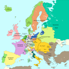
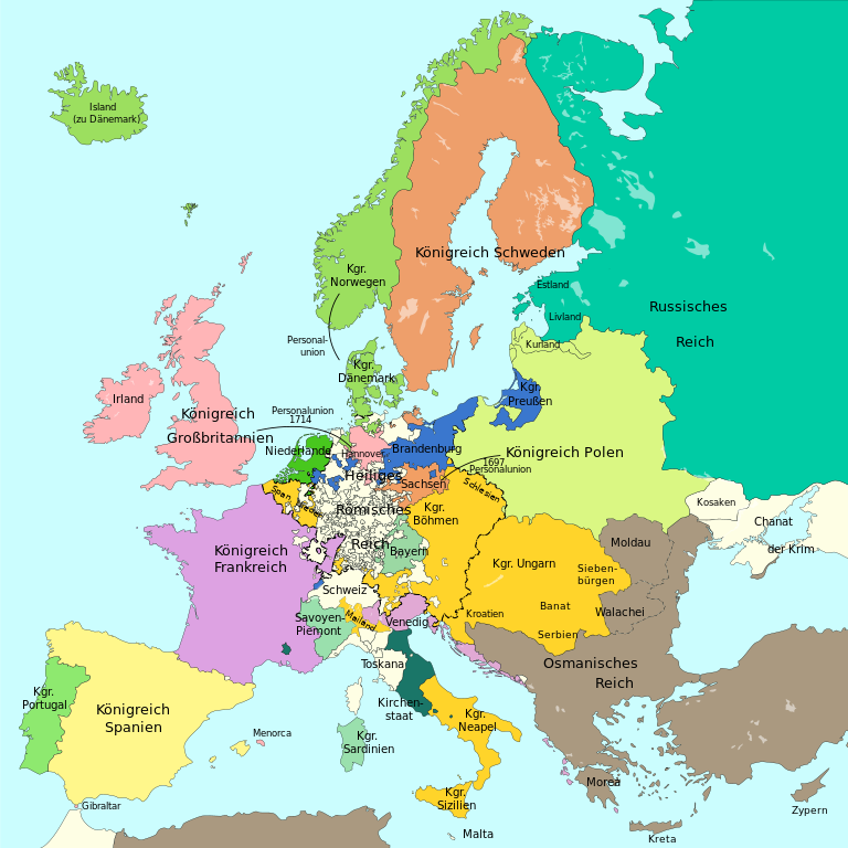
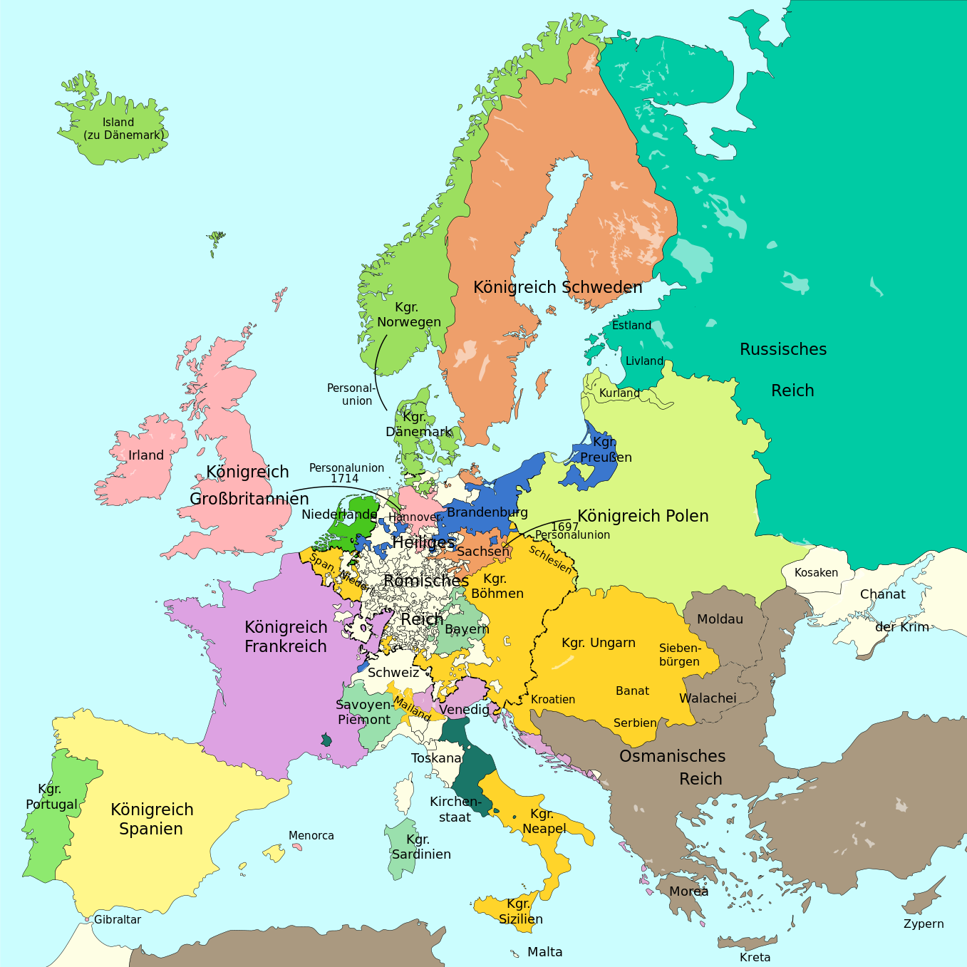
Deutsch: Eine einfache Karte von Europa am Ende des Großen Nordischen Krieges 1721.
English: A simple map showing Europe at the end of the Great Nordic War, 1721
Català: Mapa simplificat d'Europa al final de la Gran Guerra del Nord el 1721 |
||
| Date | |||
| Source |
This file was derived from: Blank map of Europe 1714.svg |
||
| Author |
|
||
| Permission (Reusing this file) |
I, the copyright holder of this work, hereby publish it under the following licenses:
This file is licensed under the Creative Commons Attribution-Share Alike 4.0 International license.
You may select the license of your choice. |
||
| Other versions |
|
||
| SVG development | This vector image was created with Adobe Illustrator. |


File history
Click on a date/time to view the file as it appeared at that time.
| Date/Time | Thumbnail | Dimensions | User | Comment | |
|---|---|---|---|---|---|
| current | 18:16, 17 September 2023 | | 1,357 × 1,357 (680 KB) | Lalpino (talk | contribs) | File uploaded using svgtranslate tool (https://svgtranslate.toolforge.org/). Added translation for ca. |
| 11:50, 20 October 2016 |  | 1,357 × 1,357 (667 KB) | Furfur (talk | contribs) | ... erneut | |
| 11:48, 20 October 2016 |  | 1,357 × 1,357 (667 KB) | Furfur (talk | contribs) | rechte Bildgrenze, Grenze in Karelien | |
| 11:03, 20 October 2016 |  | 1,387 × 1,367 (667 KB) | Furfur (talk | contribs) | Details | |
| 22:06, 16 October 2016 |  | 1,387 × 1,367 (666 KB) | Furfur (talk | contribs) | Details (Oldenburg, Toskana) | |
| 19:53, 1 October 2016 |  | 1,387 × 1,367 (666 KB) | Furfur (talk | contribs) | hellere Meeresfarbe | |
| 19:12, 1 October 2016 |  | 1,387 × 1,367 (666 KB) | Furfur (talk | contribs) | nochmal Detail | |
| 19:11, 1 October 2016 |  | 1,387 × 1,367 (666 KB) | Furfur (talk | contribs) | Details | |
| 19:04, 1 October 2016 |  | 1,387 × 1,367 (666 KB) | Furfur (talk | contribs) | == {{int:filedesc}} == {{Information |Description={{User:Medium69/Traduction}} {{de|1=Eine einfache Karte von Europa am Ende des Großen Nordischen Krieges 1721.}} {{en|1=A simple map showing Europe at the end of the Great Nordic War, 1721}} |Source={{... |
You cannot overwrite this file.
File usage on Commons
The following 12 pages use this file:
- User:Magog the Ogre/Multilingual legend/2023 September 16-20
- File:Europa 1701.svg
- File:Europa 1721.svg
- File:Europa 1789.svg
- File:Europa 1812.svg
- File:Europa 1815.svg
- File:Europa 1861.svg
- File:Europa 1867.svg
- File:Europa 1914.svg
- File:Europa 1929.svg
- File:Frieden von Nystad, Stockholm und Fredericksborg.svg
- Template:Other versions/Europa 1721
File usage on other wikis
The following other wikis use this file:
- Usage on bg.wikipedia.org
- Usage on ca.wikipedia.org
- Usage on en.wikipedia.org
- Usage on sh.wikipedia.org