File:Europa 1701.svg
Jump to navigation
Jump to search

Size of this PNG preview of this SVG file: 600 × 600 pixels. Other resolutions: 240 × 240 pixels | 480 × 480 pixels | 768 × 768 pixels | 1,024 × 1,024 pixels | 2,048 × 2,048 pixels | 1,357 × 1,357 pixels.
Original file (SVG file, nominally 1,357 × 1,357 pixels, file size: 688 KB)
Captions
Captions
Add a one-line explanation of what this file represents
Summary[edit]
| Description |
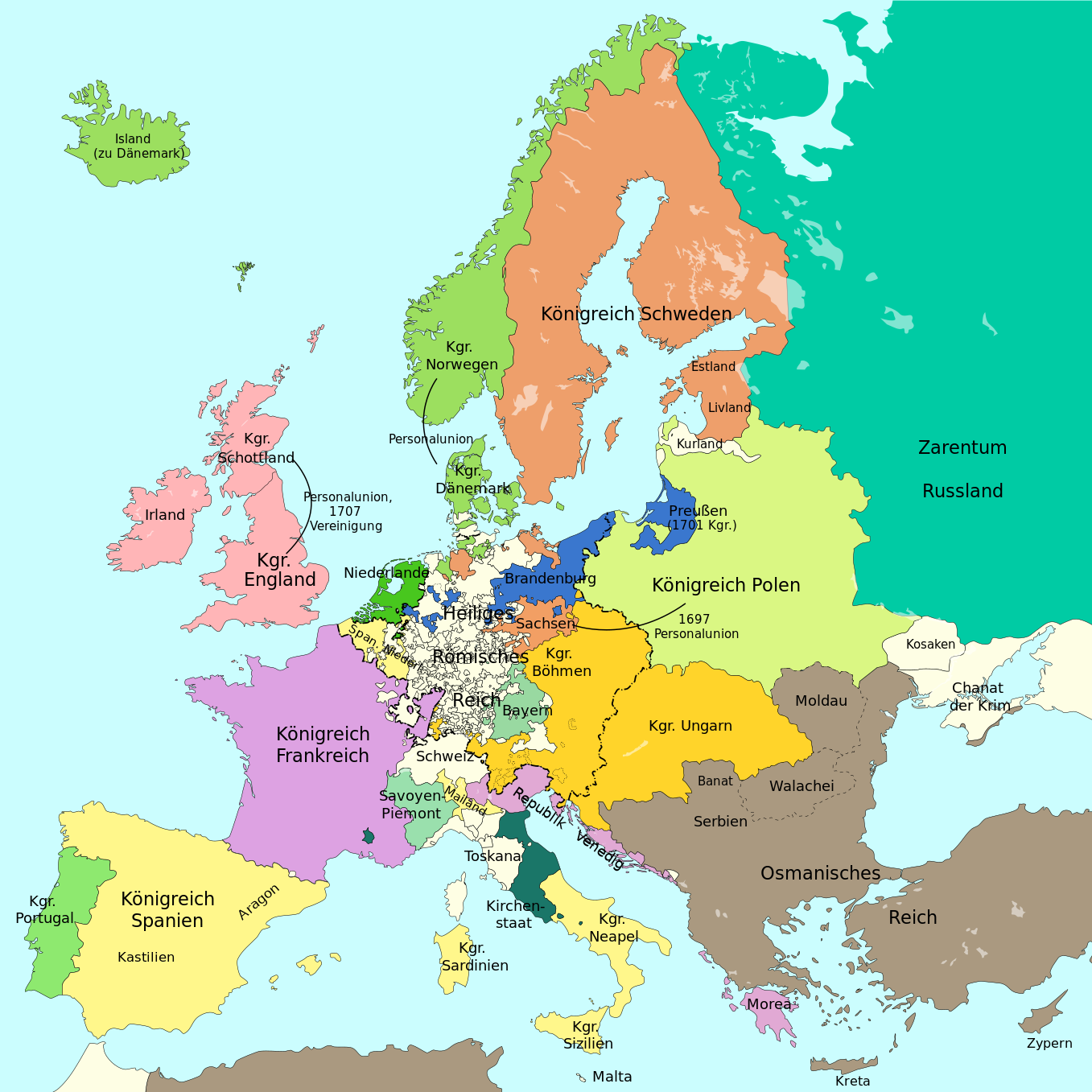
Deutsch: Eine einfache Karte von Europa am Vorabend des Spanischen Erbfolgekrieges 1701.
English: A simple map showing Europe at the start of the War of the Spanish Succession, 1701
Català: Un mapa senzill d'Europa a la vigília de la Guerra de Successió el 1701 |
||
| Date | |||
| Source |
This file was derived from: Blank map of Europe 1714.svg |
||
| Author |
|
||
| Permission (Reusing this file) |
I, the copyright holder of this work, hereby publish it under the following licenses:
This file is licensed under the Creative Commons Attribution-Share Alike 4.0 International license.
You may select the license of your choice. |
||
| Other versions |
|
||
| SVG development | This vector image was created with Adobe Illustrator. |


_en.png)
.png)
.jpg)
File history
Click on a date/time to view the file as it appeared at that time.
| Date/Time | Thumbnail | Dimensions | User | Comment | |
|---|---|---|---|---|---|
| current | 18:39, 17 September 2023 | | 1,357 × 1,357 (688 KB) | Lalpino (talk | contribs) | File uploaded using svgtranslate tool (https://svgtranslate.toolforge.org/). Added translation for ca. |
| 22:48, 19 March 2017 |  | 1,357 × 1,357 (675 KB) | Furfur (talk | contribs) | Kurland | |
| 11:54, 20 October 2016 |  | 1,357 × 1,357 (675 KB) | Furfur (talk | contribs) | Bildgrenzen | |
| 22:05, 16 October 2016 |  | 1,387 × 1,367 (676 KB) | Furfur (talk | contribs) | ... nochmal (Grafschaft Oldenburg) | |
| 21:56, 16 October 2016 |  | 1,387 × 1,367 (676 KB) | Furfur (talk | contribs) | Detail | |
| 19:19, 1 October 2016 |  | 1,387 × 1,367 (667 KB) | Furfur (talk | contribs) | einige Änderungen | |
| 17:35, 1 October 2016 |  | 1,387 × 1,367 (678 KB) | Furfur (talk | contribs) | Details | |
| 17:25, 1 October 2016 |  | 1,387 × 1,367 (679 KB) | Furfur (talk | contribs) | Morea venezianisch | |
| 20:54, 28 September 2016 |  | 1,387 × 1,367 (678 KB) | Furfur (talk | contribs) | Schweden etwas dunkler | |
| 22:36, 27 September 2016 |  | 1,387 × 1,367 (675 KB) | Furfur (talk | contribs) | ... ein letztes Mal ... |
You cannot overwrite this file.
File usage on Commons
The following 11 pages use this file:
File usage on other wikis
The following other wikis use this file:
- Usage on ca.wikipedia.org
- Usage on cs.wikipedia.org
- Usage on de.wikipedia.org
- 1701
- Spanischer Erbfolgekrieg
- Vertrag von Amsterdam (1717)
- Preußisch-russischer Allianzvertrag (1714)
- Vertrag von Schwedt
- Preußisch-russischer Allianzvertrag (1715)
- Allianzvertrag von Berlin (1715)
- Allianzvertrag von Greifswald
- Allianzvertrag von Stettin
- Haager Neutralitätskonzerte (1710)
- Waffenstillstandsangebot von Stockholm
- Liste der kriegführenden Staaten im Großen Nordischen Krieg
- Usage on en.wikipedia.org
- Usage on fr.wikipedia.org
- Usage on nn.wikipedia.org
- Usage on sh.wikipedia.org
- Usage on uk.wikipedia.org