File:ECDM 20221026 EQ Philippines.pdf
Jump to navigation
Jump to search

Size of this JPG preview of this PDF file: 800 × 554 pixels. Other resolutions: 320 × 222 pixels | 640 × 443 pixels | 1,024 × 709 pixels | 1,280 × 886 pixels | 1,625 × 1,125 pixels.
Original file (1,625 × 1,125 pixels, file size: 797 KB, MIME type: application/pdf)
Captions
Captions
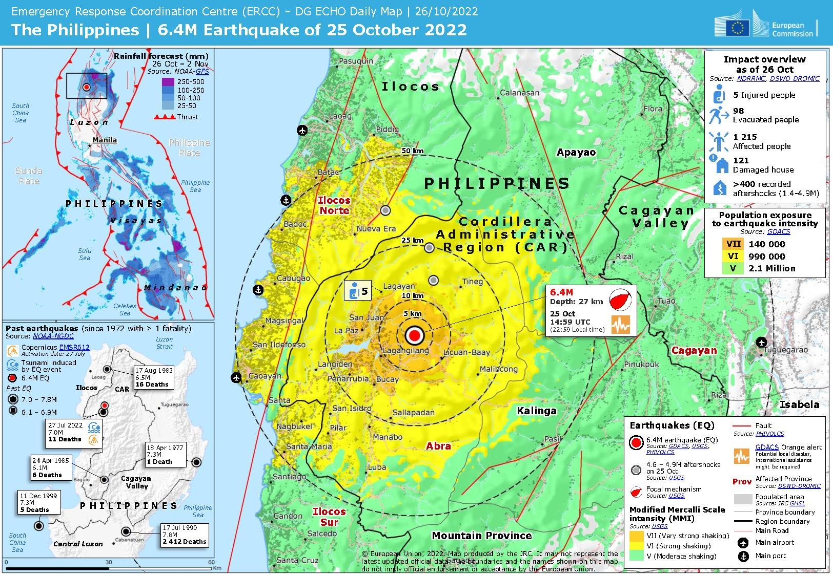
The Philippines | 6.4M Earthquake of 25 October 2022
Summary
[edit]| Description |
English: The Philippines | 6.4M Earthquake of 25 October 2022 - The Philippines | 6.4M Earthquake of 25 October 2022
|
| Date | |
| Source | https://erccportal.jrc.ec.europa.eu/ECHO-Products/Maps#/maps/4264 |
| Author | ERCC - Emergency Response Coordination Centre; Sources: GDACS, USGS, PHIVOLCS, NDRRMC, DSWD-DROMIC, Copernicus EMSR612, JRC-GHSL, NOAA-NGDC |
Licensing
[edit]Public documents (any content whatever its medium) produced by the Commission or by entities on its behalf published by the Commission or the Publications Office or which have not been published for economic or other practical reasons, such as studies, reports and other data shall be made available for reuse unless otherwise specified[1] without restrictions according to 2011/833/EU: Commission Decision of 12 December 2011 on the reuse of Commission documents
Note: Content on ec.europa.eu or its data portal is published with the specified restrictions of the CC BY 4.0 license.
| |
File history
Click on a date/time to view the file as it appeared at that time.
| Date/Time | Thumbnail | Dimensions | User | Comment | |
|---|---|---|---|---|---|
| current | 21:58, 2 November 2022 |  | 1,625 × 1,125 (797 KB) | Lupe (talk | contribs) | Uploaded a work by ERCC - Emergency Response Coordination Centre; Sources: GDACS, USGS, PHIVOLCS, NDRRMC, DSWD-DROMIC, Copernicus EMSR612, JRC-GHSL, NOAA-NGDC from https://erccportal.jrc.ec.europa.eu/ECHO-Products/Maps#/maps/4264 with UploadWizard |
You cannot overwrite this file.
File usage on Commons
There are no pages that use this file.