File:EB1 Plate LXXXVII Fig. 2 World.png
Jump to navigation
Jump to search

Size of this preview: 800 × 448 pixels. Other resolutions: 320 × 179 pixels | 640 × 358 pixels | 1,024 × 573 pixels | 1,280 × 717 pixels | 2,768 × 1,550 pixels.
Original file (2,768 × 1,550 pixels, file size: 3.34 MB, MIME type: image/png)
Captions
Captions
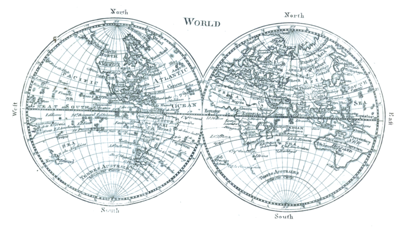
Map of the world c. 1761
Summary[edit]
| Description |
English: A map of the world as two equatorial orthographic projections of the western and eastern hemispheres as known c. 1761 from Plate LXXXVII from the Encyclopaedia Britannica, 1st ed. This map contains examples of: New Holland (Australia), Baffin Bay, Baffin Island, Cape Blanco, New Albion, Viceroyalty of New Spain, Nova Scotia, Viceroyalty of Peru, Viceroyalty of New Granada, unspecified phantom islands, Terra incognita, Saint Helena, Khoikhoi, South East Cape, Van Diemen's Land, Gulf of Carpentaria, New Britain, Nuytsland, Tartary, Veneto, Novaya Zemlya, Guinea, Sahara, Jerusalem, Arabia |
| Date | Drawn 1761, reprinted 1763 & 1764, edited & reengraved 1771. |
| Source | Encyclopaedia Britannica, 1st ed., Vol. II, p. 680 ff. Uncredited reprint of Maps 1 & 2 in the 1763 (reprinted 1764) A New General and Universal Atlas... |
| Author | Andrew Dury, engraved by Thomas Kitchen. Credited to Andrew Bell, engraver. |
| Other versions |
|


Licensing[edit]
|
This work is in the public domain in its country of origin and other countries and areas where the copyright term is the author's life plus 70 years or fewer. This work is in the public domain in the United States because it was published (or registered with the U.S. Copyright Office) before January 1, 1929. | |
| This file has been identified as being free of known restrictions under copyright law, including all related and neighboring rights. | |
| Annotations | This image is annotated: View the annotations at Commons |
File history
Click on a date/time to view the file as it appeared at that time.
| Date/Time | Thumbnail | Dimensions | User | Comment | |
|---|---|---|---|---|---|
| current | 20:15, 15 January 2023 | | 2,768 × 1,550 (3.34 MB) | LlywelynII (talk | contribs) | Uploaded a work by Andrew Bell, engraver. from ''Encyclopaedia Britannica'', 1st ed., Vol. II, [https://archive.org/details/1771EncyclopediaBritannicaNLS/First%20edition%2C%201771%20-%20Encyclopaedia%20Britannica%3B%20or%2C%20A%20dictionary%20of%20arts%20and%20sciences%2C%20compiled%20upon%20a%20new%20plan%20%E2%80%A6%2C%20Volume%202%2C%20C-L/page/n649/mode/2up p. 680 ff.] with UploadWizard |
You cannot overwrite this file.
File usage on Commons
The following 2 pages use this file:
File usage on other wikis
The following other wikis use this file:
- Usage on en.wikisource.org
Categories:
- Maps of the world without Antarctica
- Maps of the world with orthographic projection
- 1770s maps of the world
- 18th-century double hemisphere world maps
- Andrew Dury
- Maps by Thomas Kitchin
- Maps with Nicolosi globular projection
- Multilingual maps
- Maps using Ferro prime meridian
- Maps connecting Australia and New Guinea
- Company Land