File:Die Erweiterung Berlins durch das Groß-Berlin-Gesetz von 1920 (Karte).png
Jump to navigation
Jump to search
Size of this preview: 703 × 599 pixels. Other resolutions: 282 × 240 pixels | 563 × 480 pixels | 901 × 768 pixels | 1,201 × 1,024 pixels | 1,840 × 1,569 pixels.
Original file (1,840 × 1,569 pixels, file size: 609 KB, MIME type: image/png)
Captions
Captions
Add a one-line explanation of what this file represents
| Description |
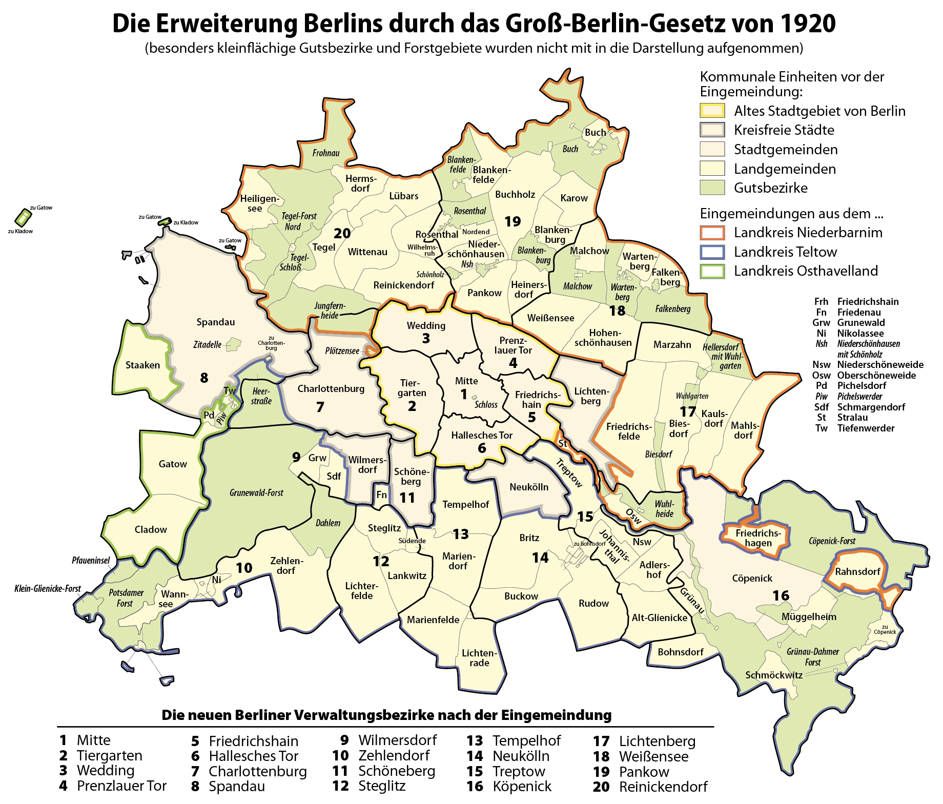
Deutsch: Karte: Die Erweiterung Berlins durch das Groß-Berlin-Gesetz von 1920 |
| Date | |
| Source | Own work |
| Author | Maximilian Dörrbecker (Chumwa) |
| Permission (Reusing this file) |
I, the copyright holder of this work, hereby publish it under the following license: This file is licensed under the Creative Commons Attribution-Share Alike 3.0 Unported license.
Sie dürfen das Bild zu den folgenden Bedingungen nutzen:
|
| Other versions |
|
.png)
_RUS.png)
File history
Click on a date/time to view the file as it appeared at that time.
| Date/Time | Thumbnail | Dimensions | User | Comment | |
|---|---|---|---|---|---|
| current | 16:58, 1 November 2012 | | 1,840 × 1,569 (609 KB) | Chumwa (talk | contribs) | der Gutsbezirk Jungfernheide gehörte komplett zum Lkr, Niederbarnim |
| 15:33, 1 November 2012 |  | 1,840 × 1,569 (611 KB) | Chumwa (talk | contribs) | Zuordnung von Bohnsdorf korrigiert, Blankenberge → Blankenburg, Gutsbezirke durchgängig mit dargestellt | |
| 11:10, 14 August 2009 |  | 1,840 × 1,569 (546 KB) | Chumwa (talk | contribs) | Muggelheim → Müggelheim, Stralau lag zuvor im Landkreis Niederbarnim | |
| 15:46, 12 August 2009 |  | 1,840 × 1,569 (545 KB) | Chumwa (talk | contribs) | Spandau war schon seit 1887 kreisfrei - danke an Definitiv für den Hinweis! | |
| 14:13, 7 August 2009 |  | 1,840 × 1,569 (538 KB) | Chumwa (talk | contribs) | Eingemeindete Städte wieder etwas neutraler dargestellt | |
| 15:38, 6 August 2009 |  | 1,840 × 1,569 (539 KB) | Chumwa (talk | contribs) | Exklave von Charlottenburg vergessen... | |
| 15:28, 6 August 2009 |  | 1,840 × 1,569 (538 KB) | Chumwa (talk | contribs) | Kreisfreie Städte aus den Landkreisen herausgenommen, kleinere Fehlebehebungen | |
| 13:45, 6 August 2009 |  | 1,840 × 1,569 (513 KB) | Chumwa (talk | contribs) | Namen der Verwaltungsbezirke aus der Hauptkarte verbannt | |
| 05:11, 6 August 2009 |  | 1,840 × 1,569 (531 KB) | Chumwa (talk | contribs) | {{Information |Description= {{ de }} Karte: Die Erweiterung Berlins durch das Groß-Berlin-Gesetz von 1920 |Source={{Own}} |Date=2009-08 |Author= Maximilian Dörrbecker (Chumwa) |Permission={{self|cc-by-sa-3.0}} Sie |
You cannot overwrite this file.
File usage on Commons
The following 4 pages use this file:
File usage on other wikis
The following other wikis use this file:
- Usage on ar.wikipedia.org
- Usage on ca.wikipedia.org
- Usage on da.wikipedia.org
- Usage on de.wikipedia.org
- Usage on en.wikipedia.org
- Usage on es.wikipedia.org
- Usage on fr.wikipedia.org
- Usage on fy.wikipedia.org
- Usage on he.wikipedia.org
- Usage on it.wikipedia.org
- Usage on ja.wikipedia.org
- Usage on ko.wikipedia.org
- Usage on nl.wikipedia.org
- Usage on no.wikipedia.org
- Usage on pt.wikipedia.org
- Usage on simple.wikipedia.org
- Usage on sv.wikipedia.org
- Usage on tl.wikipedia.org
- Usage on uk.wikipedia.org
- Usage on www.wikidata.org
- Usage on zh.wikipedia.org
.png&oldid=501090468)