Category:Maps of districts of Berlin
Jump to navigation
Jump to search
Federal states of Germany:
Subcategories
This category has the following 13 subcategories, out of 13 total.
*
- Locator maps of boroughs of Berlin (250 F)
Pages in category "Maps of districts of Berlin"
This category contains only the following page.
Media in category "Maps of districts of Berlin"
The following 48 files are in this category, out of 48 total.
-
 Abgeordnetenhauswahl Berlin - Wahlbeteiligung 2006.png 1,893 × 1,416; 318 KB
-
 Berlin Bevölkerungsdichte 2002.png 1,325 × 853; 259 KB
-
 Berlin Bewegungstypen 2002.png 1,325 × 853; 307 KB
-
 Berlin Einkommenssituation 2003.png 1,325 × 853; 274 KB
-
 Berlin Einwohnerentwicklung 98 bis 02.png 1,325 × 853; 287 KB
-
 Berlin Kita-Versorgung 2003.png 1,325 × 853; 267 KB
-
 Berlin location map simplified.svg 4,649 × 3,751; 227 KB
-
 Berlin ru.svg 4,649 × 3,751; 546 KB
-
 Berlin Subdivisions mk.svg 1,400 × 1,151; 1.61 MB
-
 Berlin Subdivisions.svg 1,400 × 1,151; 957 KB
-
 Berlin-ukr.svg 4,649 × 3,751; 485 KB
-
 Berlin.svg 4,649 × 3,751; 481 KB
-
 Berlin2.svg 4,649 × 3,751; 474 KB
-
 Berliner Bezirk Charlottenburg vor 2001.png 550 × 463; 11 KB
-
 Berliner Bezirk Friedrichshain vor 2001.png 550 × 463; 11 KB
-
 Berliner Bezirk Hellersdorf vor 2001.png 550 × 463; 11 KB
-
 Berliner Bezirk Hohenschönhausen vor 2001.png 550 × 463; 11 KB
-
 Berliner Bezirk Kreuzberg vor 2001.png 550 × 463; 11 KB
-
 Berliner Bezirk Köpenick vor 2001.png 550 × 463; 11 KB
-
 Berliner Bezirk Lichtenberg vor 2001.png 550 × 463; 11 KB
-
 Berliner Bezirk Marzahn vor 2001.png 550 × 463; 11 KB
-
 Berliner Bezirk Mitte vor 2001.png 550 × 463; 11 KB
-
 Berliner Bezirk Neukölln vor 2001.png 550 × 463; 11 KB
-
 Berliner Bezirk Pankow vor 2001.png 550 × 463; 11 KB
-
 Berliner Bezirk Prenzlauer Berg vor 2001.png 550 × 463; 11 KB
-
 Berliner Bezirk Reinickendorf vor 2001.png 550 × 463; 11 KB
-
 Berliner Bezirk Schöneberg vor 2001.png 550 × 463; 11 KB
-
 Berliner Bezirk Spandau vor 2001.png 550 × 463; 11 KB
-
 Berliner Bezirk Steglitz vor 2001.png 550 × 463; 11 KB
-
 Berliner Bezirk Tempelhof vor 2001.png 550 × 463; 11 KB
-
 Berliner Bezirk Tiergarten vor 2001.png 550 × 463; 11 KB
-
 Berliner Bezirk Treptow vor 2001.png 550 × 463; 11 KB
-
 Berliner Bezirk Wedding vor 2001.png 550 × 463; 12 KB
-
 Berliner Bezirk Weißensee vor 2001.png 550 × 463; 11 KB
-
 Berliner Bezirk Wilmersdorf vor 2001.png 550 × 463; 11 KB
-
 Berliner Bezirk Zehlendorf vor 2001.png 550 × 463; 11 KB
-
 Berliner Bezirke 2001.png 1,833 × 1,514; 156 KB
-
 Berliner Bezirke vor 2001.png 1,833 × 1,514; 207 KB
-
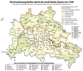 Die Erweiterung Berlins durch das Groß-Berlin-Gesetz von 1920 (Karte).png 1,840 × 1,569; 609 KB
-

-
 Germany after WWII Berlin zones F.png 550 × 463; 10 KB
-
 Germany after WWII Berlin zones UK.png 550 × 463; 10 KB
-
 Germany after WWII Berlin zones USA.png 550 × 463; 10 KB
-
 Germany divided Berlin East district names.png 550 × 463; 16 KB
-
 Germany divided Berlin West.png 550 × 463; 11 KB
-
 Templehofplanemap.png 726 × 589; 296 KB
-
 Tempschön 6.jpg 449 × 807; 48 KB
-
 WestBerlinBoroughs.png 570 × 482; 18 KB


.png)


