File:Diagrama-VLT-Carioca.svg
Jump to navigation
Jump to search

Size of this PNG preview of this SVG file: 800 × 274 pixels. Other resolutions: 320 × 110 pixels | 640 × 219 pixels | 1,024 × 351 pixels | 1,280 × 439 pixels | 2,560 × 877 pixels | 2,340 × 802 pixels.
Original file (SVG file, nominally 2,340 × 802 pixels, file size: 623 KB)
Captions
Captions
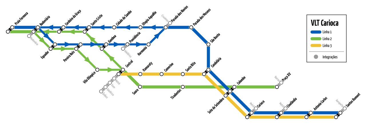
VLT Carioca lines diagram
W3C-validity not checked.
This W3C-unspecified vector image was created with Inkscape .
Summary[edit]
| Description |
Português: Diagrama de rede do VLT Carioca.
English: VLT Carioca network map. |
| Date | |
| Source | Own work(based on Diagrama-VLT-Carioca.png) |
| Author | Wanderson S. Dantas e A. Jacob |
| Permission (Reusing this file) |
CC-BY-SA-4.0 |
| Other versions |
|
Licensing[edit]
I, the copyright holder of this work, hereby publish it under the following license:
This file is licensed under the Creative Commons Attribution-Share Alike 4.0 International license.
- You are free:
- to share – to copy, distribute and transmit the work
- to remix – to adapt the work
- Under the following conditions:
- attribution – You must give appropriate credit, provide a link to the license, and indicate if changes were made. You may do so in any reasonable manner, but not in any way that suggests the licensor endorses you or your use.
- share alike – If you remix, transform, or build upon the material, you must distribute your contributions under the same or compatible license as the original.
File history
Click on a date/time to view the file as it appeared at that time.
| Date/Time | Thumbnail | Dimensions | User | Comment | |
|---|---|---|---|---|---|
| current | 01:14, 19 June 2018 | 2,340 × 802 (623 KB) | Aacj03 (talk | contribs) | Reverted to version as of 19:32, 13 April 2018 (UTC) | |
| 01:10, 19 June 2018 | 512 × 174 (409 KB) | Aacj03 (talk | contribs) | Novo trajeto das linhas 2 e 3, com a estação Duque de Caxias substituindo Itamaraty | ||
| 19:32, 13 April 2018 | 2,340 × 802 (623 KB) | Wsdantas (talk | contribs) | Correções no codigo-fonte. E validação do SVG | ||
| 17:46, 13 April 2018 | 2,340 × 802 (556 KB) | Wsdantas (talk | contribs) | User created page with UploadWizard |
You cannot overwrite this file.
File usage on Commons
The following 11 pages use this file:
- User:Chumwa/OgreBot/Potential transport maps/2018 April 11-20
- User:Chumwa/OgreBot/Potential transport maps/2018 June 11-20
- User:Chumwa/OgreBot/Public transport information/2018 April 11-20
- User:Chumwa/OgreBot/Public transport information/2018 June 11-20
- User:Chumwa/OgreBot/Transport Maps/2018 April 11-20
- User:Chumwa/OgreBot/Transport Maps/2018 June 11-20
- User:Chumwa/OgreBot/Travel and communication maps/2018 April 11-20
- User:Chumwa/OgreBot/Travel and communication maps/2018 June 11-20
- File:Diagrama-VLT-Carioca.png
- Category:Maps of Rio de Janeiro VLT
- Category:Rio de Janeiro VLT
File usage on other wikis
The following other wikis use this file:
- Usage on pt.wikipedia.org
- Usage on www.wikidata.org
- Usage on zh.wikipedia.org