File:Detailed Estate and Old Farm Line Atlas of The City of Brooklyn. Complete In Six Volumes. Vol. 6. Comprising Wards 13,14,15, 16, 17 and 19. From Official Records, Private Plans and Actual Surveys, NYPL1627543.tiff
Jump to navigation
Jump to search

Size of this JPG preview of this TIF file: 800 × 550 pixels. Other resolutions: 320 × 220 pixels | 640 × 440 pixels | 1,024 × 704 pixels | 1,280 × 880 pixels | 2,560 × 1,759 pixels | 7,230 × 4,968 pixels.
Original file (7,230 × 4,968 pixels, file size: 102.77 MB, MIME type: image/tiff)
Captions
Captions
Add a one-line explanation of what this file represents
Summary[edit]
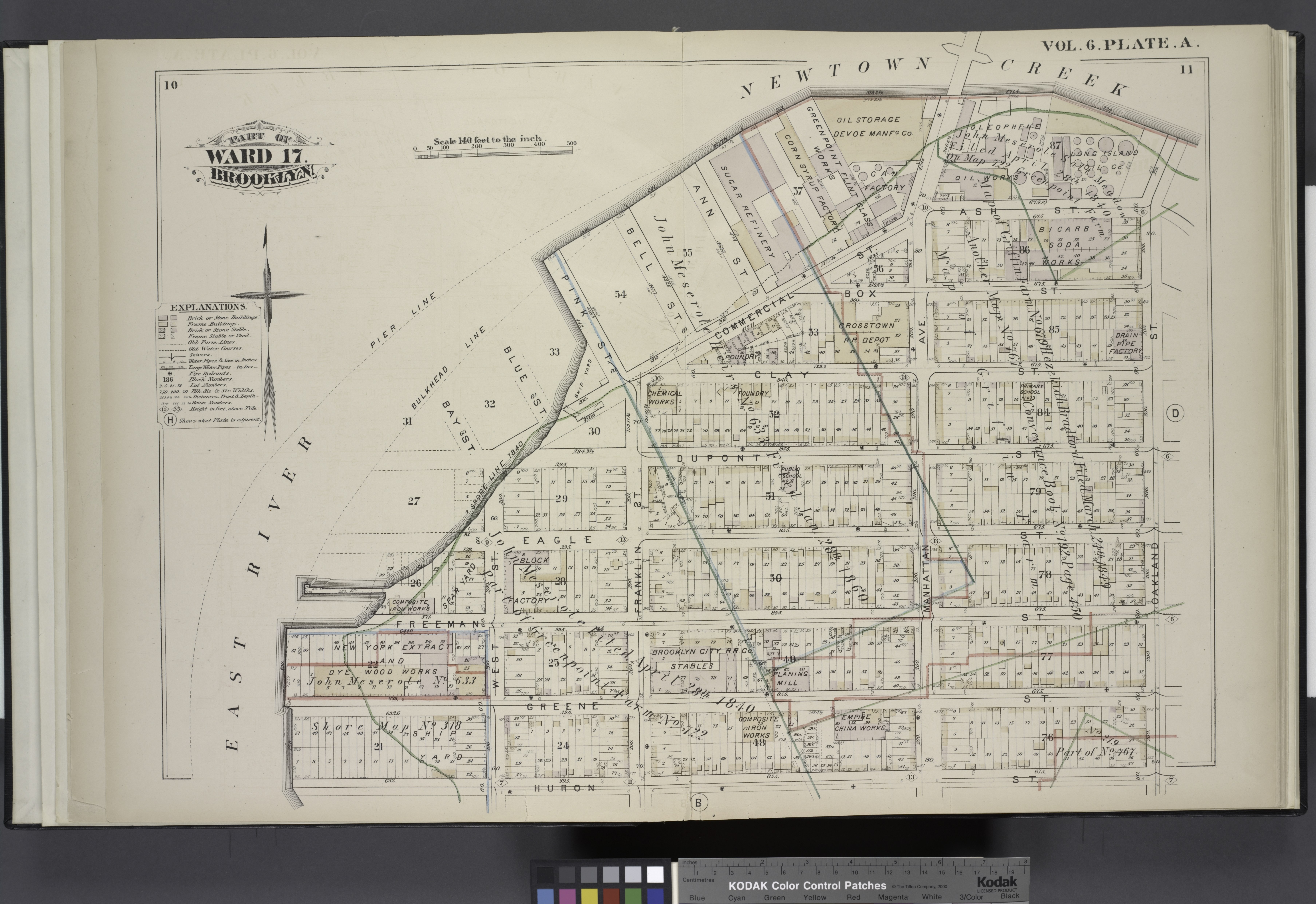
| Description | Detailed Estate and Old Farm Line Atlas of The City of Brooklyn. Complete In Six Volumes. Vol. 6. Comprising Wards 13,14,15, 16, 17 and 19. From Official Records, Private Plans and Actual Surveys, Based upon the Plans deposited in the Assessors Office. By G.M. Hopkins, C.E. 320 Walnut Street, Philadelphia. 1880.[Title Page.]; Atlases of New York city. / Detailed estate and old farm line atlas of the city of Brooklyn : complete in six volumes ... from official records, private plans, and actual surveys ... / by G.M. Hopkins, C.E. | |||||||||||||||||||||||
| Catalogue call number | Map Div.++ (New York City) (Hopkins, G.M., Company. Detailed estate and old farm line atlas of the city of Brooklyn. 1880) Library has: v.1-2, 4-6 | |||||||||||||||||||||||
| Item/Page/Plate | 10/11 | |||||||||||||||||||||||
| Date | ||||||||||||||||||||||||
| Source |
http://digitalgallery.nypl.org/nypldigital/dgkeysearchdetail.cfm?imageID=1627543
|
|||||||||||||||||||||||
| Author | ||||||||||||||||||||||||
| Permission (Reusing this file) |
From The Lionel Pincus and Princess Firyal Map Division. http://maps.nypl.org
|
|||||||||||||||||||||||
| Source description | 1 atlas (6 v.) : all col. maps (folded) ; 47 cm. | |||||||||||||||||||||||
| Location | Stephen A. Schwarzman Building / The Lionel Pincus and Princess Firyal Map Division | |||||||||||||||||||||||
| Digital item published | 4-11-2008; updated 3-25-2011 | |||||||||||||||||||||||
| Digital ID | 1627543 | |||||||||||||||||||||||

The making of this file was supported by Wikimedia UK.
To see other files made with the support of Wikimedia UK, please see the category Supported by Wikimedia UK.
|
File history
Click on a date/time to view the file as it appeared at that time.
| Date/Time | Thumbnail | Dimensions | User | Comment | |
|---|---|---|---|---|---|
| current | 16:35, 27 April 2014 |  | 7,230 × 4,968 (102.77 MB) | Fæ (talk | contribs) | GWToolset:: Creating mediafile for Fæ. Tranche 3 5495-7474 (2) |
You cannot overwrite this file.
File usage on Commons
There are no pages that use this file.