File:Deepwater Horizon incident, Gulf of Mexico, forecasted oil spill location for May 1, 2010 LOC 2010589162.tif
Jump to navigation
Jump to search
Size of this JPG preview of this TIF file: 733 × 600 pixels. Other resolutions: 293 × 240 pixels | 587 × 480 pixels | 939 × 768 pixels | 1,252 × 1,024 pixels | 2,503 × 2,048 pixels | 13,200 × 10,800 pixels.
Original file (13,200 × 10,800 pixels, file size: 407.87 MB, MIME type: image/tiff)
Captions
Captions
Add a one-line explanation of what this file represents
Summary[edit]
| Warning | The original file is very high-resolution. It might not load properly or could cause your browser to freeze when opened at full size. |
|---|
| Description |
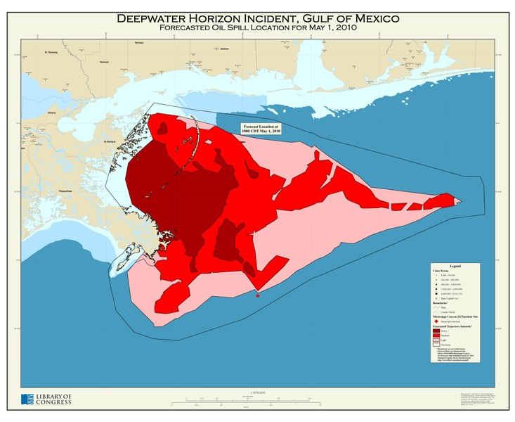
English: Depths shown by bathymetric tints. "Source: NOAA ENC, National Atlas, TeleAtlas, and NOAA/NOS/ORR Deepwater Horizon incident forecast, April 30, 2010." Available also through the Library of Congress Web site as a raster image. |
||
| Title | Deepwater Horizon incident, Gulf of Mexico, forecasted oil spill location for May 1, 2010 | ||
| Shelf ID | G3862.C6N856 2010 .J2 | ||
| Date | |||
| Source | https://www.loc.gov/item/2010589162/ | ||
| Author | Jackson, Nicholas A.; Congressional Cartography Program (Library Of Congress) | ||
| Permission (Reusing this file) |
|
||
| Other versions |
|
||
| Location | United States · Gulf Coast | ||
| Part of | American Memory · Catalog · Geography And Map Division · Additional Conservation And Environment Cartographic Items | ||
| Subject | Gulf Coast (U.S.) · Bp Deepwater Horizon Explosion And Oil Spill · United States · Maps · Gulf Coast · Oil Spills |


Licensing[edit]
This image is in the public domain because it contains materials that originally came from the U.S. National Oceanic and Atmospheric Administration, taken or made as part of an employee's official duties.
|
File history
Click on a date/time to view the file as it appeared at that time.
| Date/Time | Thumbnail | Dimensions | User | Comment | |
|---|---|---|---|---|---|
| current | 17:41, 9 May 2018 |  | 13,200 × 10,800 (407.87 MB) | Fæ (talk | contribs) | LOC Maps https://www.loc.gov/item/2010589162/ #3 |
You cannot overwrite this file.
File usage on Commons
The following page uses this file: