File:DETAIL OF CONCRETE BLOCKS - Kuhlman-Periman Ranch, County Route 28, Dolores, Montezuma County, CO HABS COLO,42-DOL.V,2-3.tif
Jump to navigation
Jump to search

Size of this JPG preview of this TIF file: 474 × 599 pixels. Other resolutions: 190 × 240 pixels | 380 × 480 pixels | 607 × 768 pixels | 810 × 1,024 pixels | 1,620 × 2,048 pixels | 3,950 × 4,993 pixels.
Original file (3,950 × 4,993 pixels, file size: 18.81 MB, MIME type: image/tiff)
Captions
Captions
Add a one-line explanation of what this file represents
Summary[edit]
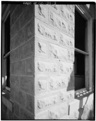
| DETAIL OF CONCRETE BLOCKS - Kuhlman-Periman Ranch, County Route 28, Dolores, Montezuma County, CO | ||||
|---|---|---|---|---|
| Photographer |
Related names:
|
|||
| Title |
DETAIL OF CONCRETE BLOCKS - Kuhlman-Periman Ranch, County Route 28, Dolores, Montezuma County, CO |
|||
| Depicted place | Colorado; Montezuma County; Dolores | |||
| Date | Documentation compiled after 1933 | |||
| Dimensions | 4 x 5 in. | |||
| Current location |
Library of Congress Prints and Photographs Division Washington, D.C. 20540 USA http://hdl.loc.gov/loc.pnp/pp.print |
|||
| Accession number |
HABS COLO,42-DOL.V,2-3 |
|||
| Credit line |
|
|||
| Notes |
|
|||
| Source | https://www.loc.gov/pictures/item/co0094.photos.021687p | |||
| Permission (Reusing this file) |
|
|||

| Object location | | View this and other nearby images on: OpenStreetMap |
|---|
File history
Click on a date/time to view the file as it appeared at that time.
| Date/Time | Thumbnail | Dimensions | User | Comment | |
|---|---|---|---|---|---|
| current | 09:29, 8 July 2014 |  | 3,950 × 4,993 (18.81 MB) | Fæ (talk | contribs) | GWToolset: Creating mediafile for Fæ. HABS 05 July 2014 (501:600) |
You cannot overwrite this file.
File usage on Commons
The following page uses this file: