File:Départements et régions de France es.svg
Jump to navigation
Jump to search

Size of this PNG preview of this SVG file: 588 × 550 pixels. Other resolutions: 257 × 240 pixels | 513 × 480 pixels | 821 × 768 pixels | 1,095 × 1,024 pixels | 2,190 × 2,048 pixels.
Original file (SVG file, nominally 588 × 550 pixels, file size: 437 KB)
Captions
Captions
Add a one-line explanation of what this file represents
Summary[edit]
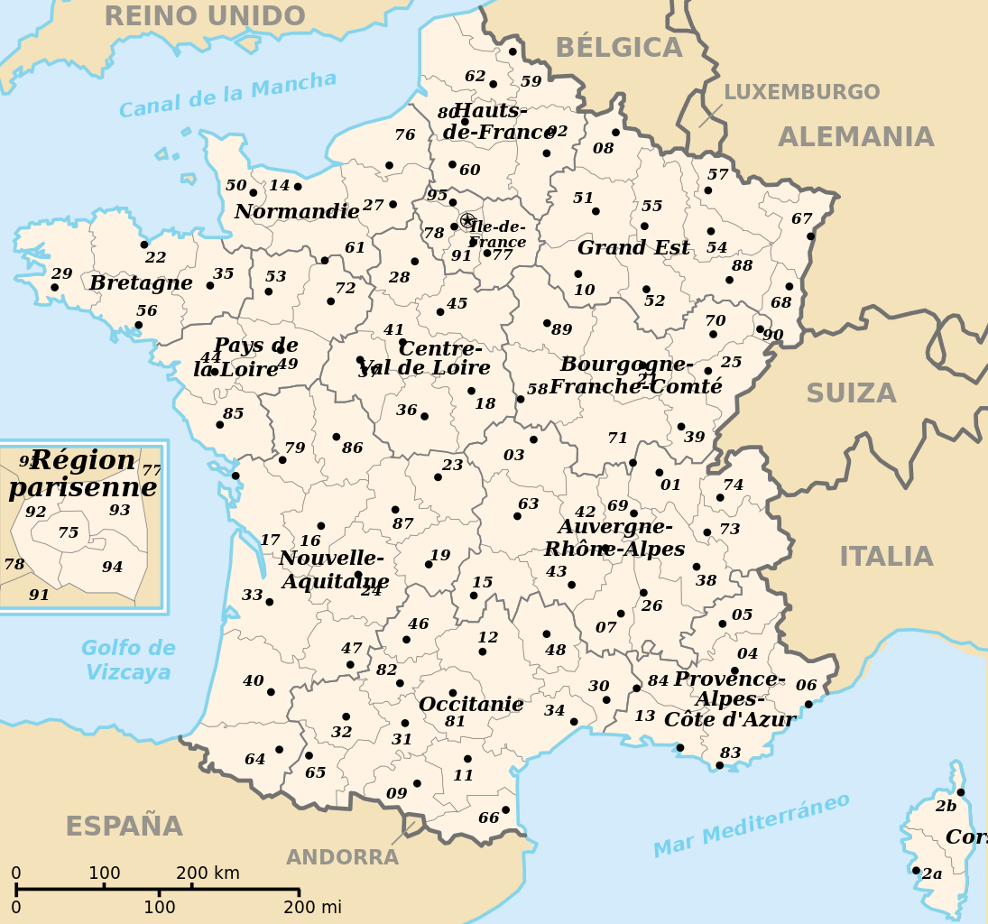
| Description |
English: Departements and region of France. French geographics objects use ISO 3166-2:FR for ids.
Español: Mapa de los departamentos y regiones franceses.
Français : Départements et régions de France avec leurs préfectures. Les objects géographiques français utilisent les identifiants provenant de ISO 3166-2:FR. |
||
| Date | (UTC) | ||
| Source |
This file was derived from: Départements et régions de France.svg: |
||
| Author |
|
||
| Permission (Reusing this file) |
|
||
| Other versions |
[]
|
![(français) Départements (numérotés) et régions de France avant 01/01/2016 (nommées, non colorisés) [source of all the following derivatives]](/wiki/File:D%C3%A9partements_et_r%C3%A9gions_de_France.svg)


![(français) Départements (numérotés) et régions de France avant 01/01/2016 (non nommées, non colorisées) [rendu amélioré] (version utilisée pour rendre la carte clicable par département)](/wiki/File:D%C3%A9partements_et_r%C3%A9gions_de_France_-_Noname-2016.svg)


![(français) Départements (numérotés) et régions de France avant 01/01/2016 (nommées et colorisées) [regions named/colored]](/wiki/File:D%C3%A9partements%2Br%C3%A9gions_(France).svg)
![(français) Départements (numérotés) et régions de France avant 01/01/2016 (nommées et colorisées) [15% magnified, rapid JPEG format 5x faster]](/wiki/File:France_departements_regions_narrow.jpg)
![(français) Départements de France (numérotés, non colorisés)[numeric labels, uncolorized]](/wiki/File:D%C3%A9partements_de_France.svg)


![(multilingue) Départements de France (sans aucun libellé) [No labels]](/wiki/File:D%C3%A9partements_et_r%C3%A9gions_de_France_vide.svg)
Original upload log[edit]
This image is a derivative work of the following images:
- File:Départements_et_régions_de_France.svg licensed with PD-self
- 2009-05-16T02:55:39Z Archimatth 588x550 (477536 Bytes) Une seule préfecture varoise
- 2008-06-20T07:26:42Z Bayo 588x550 (478078 Bytes) patch region/departement id with ISO 3166-2:FR
- 2008-06-17T09:02:28Z Bayo 588x550 (485696 Bytes) {{Information |Description= |Source= |Date= |Author= |Permission= |other_versions= }}
- 2008-05-10T16:56:23Z Bayo 588x550 (470290 Bytes) region name bigger, patch typo of some names
- 2006-05-22T20:34:29Z Bayo 588x550 (470278 Bytes) patch : typo
- 2006-04-17T15:11:41Z Bayo 588x550 (470275 Bytes) ajout de l'échelle
- 2006-04-17T14:45:23Z Bayo 588x550 (465538 Bytes) *'''description''' : Départements et régions et de France avec leurs préfectures. *'''auteur''' : [[User:bayo|bayo]] [[Category:Maps of departements of France]] [[Category:Maps of régions of France]] == Licensing == {{PD-self}}
Uploaded with derivativeFX
File history
Click on a date/time to view the file as it appeared at that time.
| Date/Time | Thumbnail | Dimensions | User | Comment | |
|---|---|---|---|---|---|
| current | 09:39, 12 April 2024 | | 588 × 550 (437 KB) | Jack ma (talk | contribs) | Updated French administrative regions of 2016 |
| 20:23, 23 February 2012 |  | 588 × 550 (465 KB) | Robot8A (talk | contribs) | == {{int:filedesc}} == {{Information |Description={{en|Departements and region of France. French geographics objects use ISO 3166-2:FR for ids.}} {{es|Mapa de los departamentos franceses.}} {{fr|Départements et régions de France avec leurs préfectur... |
You cannot overwrite this file.
File usage on Commons
The following 16 pages use this file:
- User:Magog the Ogre/Multilingual legend/2024 April 11-15
- File:Departamantoù Frañs.svg
- File:Departamentos e rexións de Francia.svg
- File:Dipartimenti francesi.svg
- File:Départements de France.svg
- File:Départements de France English.svg
- File:Départements de France Korean.svg
- File:Départements de France Macedonian.svg
- File:Départements de France VI.svg
- File:Départements de France hr.svg
- File:Départements et régions de France.svg
- File:Départements et régions de France eo.svg
- File:Départements et régions de France es.svg
- File:Départements et régions de France vide.svg
- File:Regiones metropolitanas de Francia.svg
- Template:Other versions/Départements et régions de France
File usage on other wikis
The following other wikis use this file:
- Usage on es.wikipedia.org