File:Celts in Europe-fr.svg
Jump to navigation
Jump to search

Size of this PNG preview of this SVG file: 800 × 592 pixels. Other resolutions: 320 × 237 pixels | 640 × 473 pixels | 1,024 × 757 pixels | 1,280 × 947 pixels | 2,560 × 1,893 pixels | 933 × 690 pixels.
Original file (SVG file, nominally 933 × 690 pixels, file size: 165 KB)
Captions
Captions
Add a one-line explanation of what this file represents
Summary[edit]
| Description |
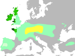
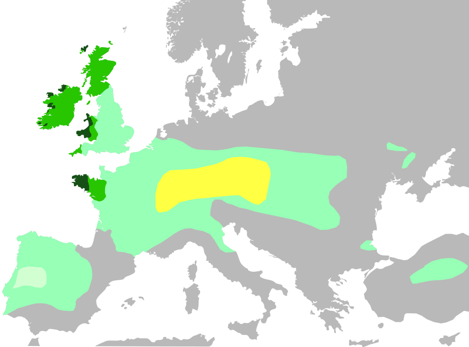
Français : Cette carte montre :
Noyau territorial Hallstatt, au VI siècle avant J.-C.
Expansion celtique maximale, en 275 avant J.-C.
Domaine lusitanien de l'Ibérie où la présence celtique est incertaine
Les six nations celtiques officielles aujourd'hui et qui pratiquaient le langage celtique au Moyen Âge (Bretagne, Pays de Galles, Cornouailles, Ile de Man, Irlande, Ecosse)
Zones où les langues celtiques restent largement parlées aujourd'hui English: Celts in Europe
the core Hallstatt territory, expansion before 500 BCE
maximum Celtic expansion by the 270s BCE
Lusitanian area of Iberia, "Celticity" uncertain
the boundaries of the six commonly-recognized 'Celtic nations', which remained Celtic speaking throughout the Middle Ages (viz. Brittany, Wales, Cornwall, Isle of Man, Ireland, Scotland)
areas that remain Celtic-speaking today Deutsch: Verbreitung keltischer Völker und Sprachen: Gebiet der Hallstatt-Kultur im 6. Jahrhundert v. Chr.
Größte keltische Ausdehnung, um 275 v. Chr.
Lusitania (keltische Besiedlung unsicher)
Die „sechs Keltischen Nationen“ in denen es bis in die Frühe Neuzeit eine signifikante Anzahl Sprecher keltischer Sprachen gab.
Das heutige Verbreitungsgebiet keltischer Sprachen |
| Date | |
| Source | |
| Author | QuartierLatin1968, The Ogre, Dbachmann, Superwikifan; derivative work Augusta 89 |
| Other versions |
|

Licensing[edit]
I, the copyright holder of this work, hereby publish it under the following license:
This file is licensed under the Creative Commons Attribution-Share Alike 3.0 Unported license.
- You are free:
- to share – to copy, distribute and transmit the work
- to remix – to adapt the work
- Under the following conditions:
- attribution – You must give appropriate credit, provide a link to the license, and indicate if changes were made. You may do so in any reasonable manner, but not in any way that suggests the licensor endorses you or your use.
- share alike – If you remix, transform, or build upon the material, you must distribute your contributions under the same or compatible license as the original.
File history
Click on a date/time to view the file as it appeared at that time.
| Date/Time | Thumbnail | Dimensions | User | Comment | |
|---|---|---|---|---|---|
| current | 18:35, 4 November 2016 | | 933 × 690 (165 KB) | Rob984 (talk | contribs) | Adjusted colour of sea and land to conform to widely used grey-white style, which I think looks better. Adds focus on the colour part of the map. |
| 16:04, 3 July 2014 |  | 933 × 695 (274 KB) | Kopiersperre (talk | contribs) | same colours like in File:Celts in Europe.png | |
| 12:04, 14 June 2014 |  | 933 × 695 (274 KB) | Augusta 89 (talk | contribs) | User created page with UploadWizard |
You cannot overwrite this file.
File usage on Commons
The following 5 pages use this file:
File usage on other wikis
The following other wikis use this file:
- Usage on arz.wikipedia.org
- Usage on ast.wikipedia.org
- Usage on ca.wikipedia.org
- Usage on de.wikipedia.org
- Usage on de.wikivoyage.org
- Usage on en.wikipedia.org
- Usage on es.wikipedia.org
- Usage on eu.wikipedia.org
- Usage on fr.wikipedia.org
- Usage on fr.wikibooks.org
- Usage on ga.wikipedia.org
- Usage on gl.wikipedia.org
- Usage on hu.wikipedia.org
- Usage on lv.wikipedia.org
- Usage on pcd.wikipedia.org
- Usage on pt.wikipedia.org
- Usage on rm.wikipedia.org
- Usage on vec.wikipedia.org
- Usage on www.wikidata.org
- Usage on zh.wikipedia.org