File:Caucasus 1450 map de alt.svg
Jump to navigation
Jump to search

Size of this PNG preview of this SVG file: 771 × 599 pixels. Other resolutions: 309 × 240 pixels | 618 × 480 pixels | 988 × 768 pixels | 1,280 × 995 pixels | 2,560 × 1,990 pixels | 1,155 × 898 pixels.
Original file (SVG file, nominally 1,155 × 898 pixels, file size: 4.48 MB)
Captions
Captions
Add a one-line explanation of what this file represents
Summary[edit]
| Description |
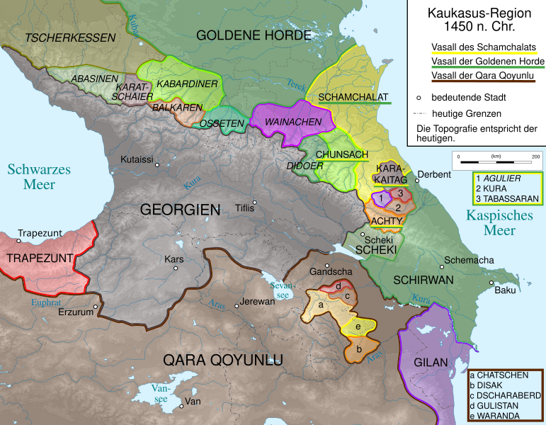
English: Map of Caucasus Region 1460 in German.
Deutsch: Kaukasus-Region Anfang 1460 n. Chr. Quellen sind:
|
| Date | |
| Source | Own work, derivate of File:Caucasus_topographic_map-fr.svg |
| Author |
|
| Other versions |
 |
Licensing[edit]
I, the copyright holder of this work, hereby publish it under the following licenses:

|
Permission is granted to copy, distribute and/or modify this document under the terms of the GNU Free Documentation License, Version 1.2 or any later version published by the Free Software Foundation; with no Invariant Sections, no Front-Cover Texts, and no Back-Cover Texts. A copy of the license is included in the section entitled GNU Free Documentation License. |
This file is licensed under the Creative Commons Attribution-Share Alike 3.0 Unported, 2.5 Generic, 2.0 Generic and 1.0 Generic license.
- You are free:
- to share – to copy, distribute and transmit the work
- to remix – to adapt the work
- Under the following conditions:
- attribution – You must give appropriate credit, provide a link to the license, and indicate if changes were made. You may do so in any reasonable manner, but not in any way that suggests the licensor endorses you or your use.
- share alike – If you remix, transform, or build upon the material, you must distribute your contributions under the same or compatible license as the original.
You may select the license of your choice.
File history
Click on a date/time to view the file as it appeared at that time.
| Date/Time | Thumbnail | Dimensions | User | Comment | |
|---|---|---|---|---|---|
| current | 20:13, 20 April 2020 | | 1,155 × 898 (4.48 MB) | Don-kun (talk | contribs) | some corrections after further inquiry |
| 09:00, 21 February 2020 |  | 1,155 × 898 (4.48 MB) | WajWohu (talk | contribs) | Reverted to version as of 18:33, 9 September 2014 (UTC) Wainakh tukkhums and teips had no settlement until the Koisu region that year according all historical sources. Reverted erasure of Shamkhalate dominating Dagestan that year. | |
| 23:02, 18 February 2020 |  | 1,155 × 898 (4.46 MB) | Takhirgeran Umar (talk | contribs) | об | |
| 18:33, 9 September 2014 |  | 1,155 × 898 (4.48 MB) | Don-kun (talk | contribs) | correction according Hewsen, Armenia: a historical atlas | |
| 10:45, 9 June 2014 |  | 1,155 × 898 (4.47 MB) | Don-kun (talk | contribs) | changes like in the png version | |
| 19:47, 20 August 2011 |  | 1,155 × 898 (4.44 MB) | Don-kun (talk | contribs) | correction north Caucasus | |
| 09:03, 3 June 2011 |  | 1,155 × 898 (4.43 MB) | Don-kun (talk | contribs) | {{Information |Description ={{en|1=Map of Caucasus Region 1460 in German.}} {{de|1=Kaukasus-Region Anfang 1460 n. Chr. Quellen sind: * Heinz Fähnrich: ''Geschichte Georgiens von den Anfängen bis zur Mongolenherrschaft''. Shaker, Aachen 1993, ISBN 3-8 |
You cannot overwrite this file.
File usage on Commons
The following 4 pages use this file:
File usage on other wikis
The following other wikis use this file:
- Usage on azb.wikipedia.org
- Usage on az.wikipedia.org
- Usage on cs.wikipedia.org
- Usage on en.wikipedia.org
- Usage on hr.wikipedia.org
- Usage on ka.wikipedia.org
- Usage on nl.wikipedia.org
- Usage on ru.wikipedia.org
- Usage on tr.wikipedia.org
- Usage on vi.wikipedia.org
- Usage on www.wikidata.org
Metadata
Categories:
- Maps of the history of the Caucasus
- SVG maps of the history of Georgia
- SVG maps of the history of Armenia
- SVG maps of the history of Azerbaijan
- Maps of the history of the south Caucasus region
- Maps of the history of Adygea
- Maps of the history of Karachay-Cherkessia
- Maps of the history of Kabardino-Balkaria
- Maps of the history of North Ossetia – Alania
- Maps of the Caucasus by user Don-kun
- Maps of the history of Dagestan
- Maps showing the 1450s