File:Caucasus 1000 map de.png
Jump to navigation
Jump to search

Size of this preview: 771 × 599 pixels. Other resolutions: 309 × 240 pixels | 618 × 480 pixels | 988 × 768 pixels | 1,280 × 995 pixels | 2,560 × 1,990 pixels | 2,990 × 2,324 pixels.
Original file (2,990 × 2,324 pixels, file size: 3.74 MB, MIME type: image/png)
Captions
Captions
Add a one-line explanation of what this file represents
|
Summary[edit]
| Description |
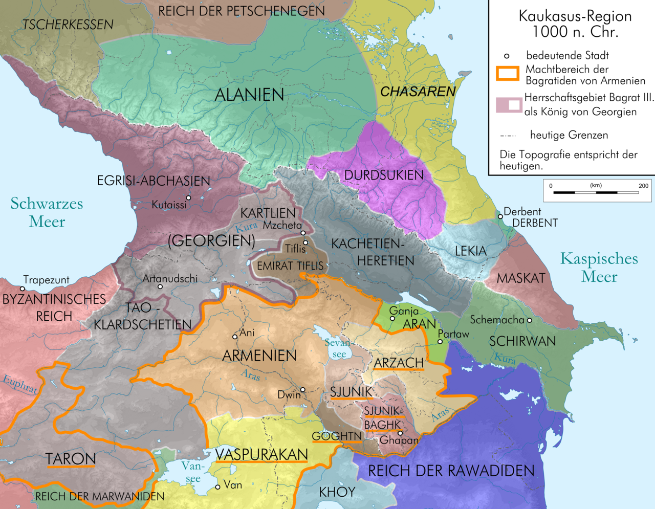
English: Map of Caucasus Region at 1000 AD before death of Dawit III., in German.
Deutsch: Kaukasus-Region 1000 n. Chr. vor dem Tod Dawits III.; Quellen sind Putzger historischer Weltatlas Ausgabe 2005, Heinz Fähnrich: Geschichte Georgiens von den Anfängen bis zur Mongolenherrschaft. Shaker, Aachen 1993, ISBN 3-86111-683-9, File:Georgia map 830-1020.gif , File:Arcax.jpg , File:Vaspurakan kingdom 908-1021 map-fr.svg , http://www.armenica.org/cgi-bin/armenica.cgi?178711717323498=1=3==Armenia==1=3=AAA , File:Alania 10 12.png |
| Date | |
| Source | Own work by uploaderderivate of File:Caucasus topographic map-fr.svg |
| Author | Don-kun |
| Other versions |
   |
Licensing[edit]
I, the copyright holder of this work, hereby publish it under the following licenses:
This file is licensed under the Creative Commons Attribution-Share Alike 3.0 Unported license.
- You are free:
- to share – to copy, distribute and transmit the work
- to remix – to adapt the work
- Under the following conditions:
- attribution – You must give appropriate credit, provide a link to the license, and indicate if changes were made. You may do so in any reasonable manner, but not in any way that suggests the licensor endorses you or your use.
- share alike – If you remix, transform, or build upon the material, you must distribute your contributions under the same or compatible license as the original.

|
Permission is granted to copy, distribute and/or modify this document under the terms of the GNU Free Documentation License, Version 1.2 or any later version published by the Free Software Foundation; with no Invariant Sections, no Front-Cover Texts, and no Back-Cover Texts. A copy of the license is included in the section entitled GNU Free Documentation License. |
You may select the license of your choice.
File history
Click on a date/time to view the file as it appeared at that time.
| Date/Time | Thumbnail | Dimensions | User | Comment | |
|---|---|---|---|---|---|
| current | 23:02, 13 January 2010 | | 2,990 × 2,324 (3.74 MB) | Don-kun (talk | contribs) | correction, new sources |
| 15:10, 19 June 2009 |  | 3,000 × 2,332 (3.69 MB) | Don-kun (talk | contribs) | k | |
| 15:01, 19 June 2009 |  | 3,000 × 2,332 (3.69 MB) | Don-kun (talk | contribs) | small cor | |
| 11:32, 19 June 2009 |  | 3,000 × 2,332 (3.69 MB) | Don-kun (talk | contribs) | change colors | |
| 17:20, 18 June 2009 |  | 3,000 × 2,332 (3.83 MB) | Don-kun (talk | contribs) | change text | |
| 09:20, 18 June 2009 |  | 3,000 × 2,332 (3.83 MB) | Don-kun (talk | contribs) | small changes | |
| 15:53, 11 June 2009 |  | 3,000 × 2,348 (3.81 MB) | Don-kun (talk | contribs) | some small corrections | |
| 12:55, 10 June 2009 |  | 3,000 × 2,348 (3.81 MB) | Don-kun (talk | contribs) | k | |
| 19:19, 9 June 2009 |  | 3,000 × 2,348 (3.82 MB) | Don-kun (talk | contribs) | {{Information |Description={{en|1=Map of Caucasus Region at 1000 AD before death of Dawit III., in German.}} {{de|1=Kaukasus-Region 1000 n. Chr. vor dem Tod Dawits III.; Quellen sind Putzger historischer Weltatlas Ausgabe 2005, Heinz Fähnrich: Geschichte |
You cannot overwrite this file.
File usage on Commons
The following 9 pages use this file:
File usage on other wikis
The following other wikis use this file:
- Usage on az.wikipedia.org
- Usage on be-tarask.wikipedia.org
- Usage on bs.wikipedia.org
- Usage on ckb.wikipedia.org
- Usage on cs.wikipedia.org
- Usage on de.wikipedia.org
- Kumyken
- Abchasien
- Tao-Klardschetien
- Königreich Georgien
- Wikipedia:Exzellente Bilder/Karten und Satellitenbilder
- Benutzer Diskussion:René Mettke
- Königreich Arzach
- Benutzer:Mikullovci11/Work/Karten
- Wikipedia:Kandidaten für exzellente Bilder/Archiv2009/10
- Datei:Caucasus 1000 map de.png
- Benutzer Diskussion:Don-kun/Archiv4
- Wikipedia:Kandidaten für exzellente Bilder/Archiv2010/1
- Königreich Abchasien
- Benutzer:Don-kun/Kartenserie Kaukasus
- Gurandukt von Abchasien
- Usage on en.wikipedia.org
- Usage on es.wikipedia.org
- Usage on eu.wikipedia.org
- Usage on fr.wikipedia.org
- Usage on hr.wikipedia.org
- Usage on hy.wikipedia.org
- Usage on it.wikipedia.org
- Usage on ja.wikipedia.org
- Usage on ka.wikipedia.org
- Usage on kbd.wikipedia.org
- Usage on ko.wikipedia.org
- Usage on ku.wikipedia.org
- Usage on lt.wikipedia.org
- Usage on lv.wikipedia.org
- Usage on mt.wikipedia.org
- Usage on nl.wikipedia.org
- Usage on pl.wikipedia.org
- Usage on ru.wikipedia.org
View more global usage of this file.
Metadata
Categories:
- Maps of the history of Georgia
- Maps of the Bagratuni Kingdom of Armenia
- PNG maps of the history of Azerbaijan
- Maps of the history of the Caucasus
- Maps of the history of Abkhazia
- Maps of the history of South Ossetia
- Maps of the history of the south Caucasus region
- Maps of the history of Naxçıvan
- Maps of Alania
- Maps of the Khazars
- Maps of Circassia
- Maps of the history of Adygea
- Maps of the history of Karachay-Cherkessia
- Maps of the history of Kabardino-Balkaria
- Maps of the history of North Ossetia – Alania
- Maps of the history of Dagestan
- Derivative maps of Putzgers Historischer Schul-Atlas
- Maps of the Caucasus by user Don-kun