File:Carte generale du monde, ou, Description du monde terrestre and aquatique = Generale waereld kaart, of, Beschryving van de land en water aereld - I. van Lutchtenberg, delin. et sculpcit. NYPL465238.tiff
Jump to navigation
Jump to search

Size of this JPG preview of this TIF file: 720 × 600 pixels. Other resolutions: 288 × 240 pixels | 576 × 480 pixels | 922 × 768 pixels | 1,229 × 1,024 pixels | 2,458 × 2,048 pixels | 6,299 × 5,248 pixels.
Original file (6,299 × 5,248 pixels, file size: 94.6 MB, MIME type: image/tiff)
Captions
Captions
Add a one-line explanation of what this file represents
Summary[edit]
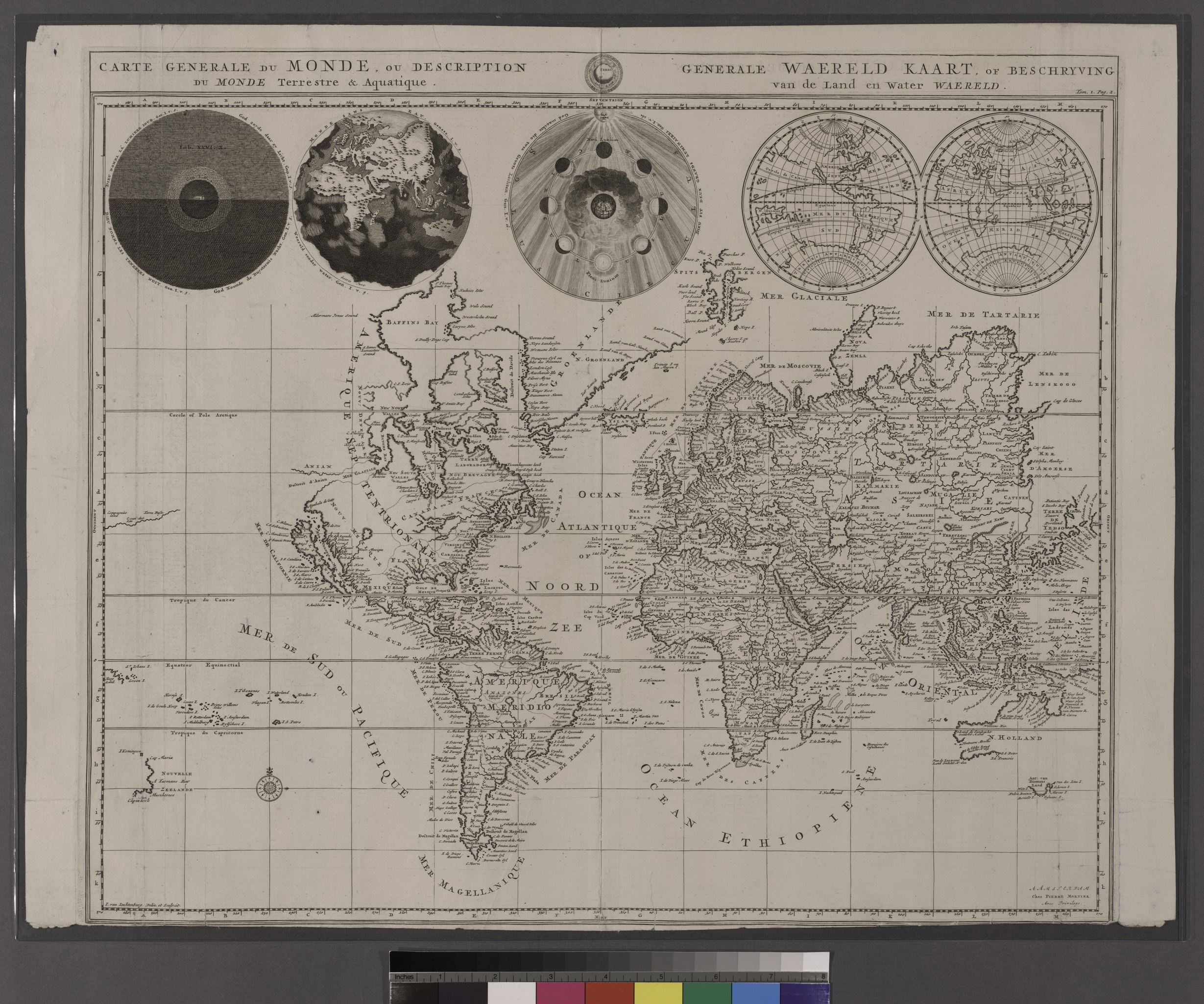
| Description | Carte generale du monde, ou, Description du monde terrestre and aquatique = Generale waereld kaart, of, Beschryving van de land en water aereld / I. van Lutchtenberg, delin. et sculpcit.; John H. Levine Collection | |||||||||||||||||||||||
| Notes | "Avec privilege." ''Note 2.'') In upper right corner, above neat line: Tom. I. Pag. 2. ''Note 3.'') Includes five circles showing Night and Day, the Flood, the phases of the moon, and the west and east hemispheres. ''Note 4.'') John H. Levine Bequest. ''Note 5.'') National Endowment for the Humanities Grant for Access to Early Maps of the Middle Atlantic Seaboard. ''Note 6.'') Watermark. | |||||||||||||||||||||||
| Item physical description | 1 map; 37 x 46 cm. | |||||||||||||||||||||||
| Catalogue call number | Map Div. 96-7629 [Levine] | |||||||||||||||||||||||
| Standard reference | Shirley, R.W. Mapping of the world, 622 | |||||||||||||||||||||||
| Date | circa 1700 | |||||||||||||||||||||||
| Source |
http://digitalgallery.nypl.org/nypldigital/dgkeysearchdetail.cfm?imageID=465238
|
|||||||||||||||||||||||
| Author | Pierre - Cartographer Mortier | |||||||||||||||||||||||
| Permission (Reusing this file) |
From The Lionel Pincus and Princess Firyal Map Division. http://maps.nypl.org
|
|||||||||||||||||||||||
| Location | Stephen A. Schwarzman Building / The Lionel Pincus and Princess Firyal Map Division | |||||||||||||||||||||||
| Digital item published | 9-15-2005; updated 3-25-2011 | |||||||||||||||||||||||
| Digital ID | 465238 | |||||||||||||||||||||||

The making of this file was supported by Wikimedia UK.
To see other files made with the support of Wikimedia UK, please see the category Supported by Wikimedia UK.
|
File history
Click on a date/time to view the file as it appeared at that time.
| Date/Time | Thumbnail | Dimensions | User | Comment | |
|---|---|---|---|---|---|
| current | 08:02, 6 May 2014 |  | 6,299 × 5,248 (94.6 MB) | Fæ (talk | contribs) | GWToolset: Creating mediafile for Fæ. Tranche 3 3501-5495 (repairs) @ 4 May 2014, 10:46 BST |
You cannot overwrite this file.
File usage on Commons
There are no pages that use this file.