File:Carte des sites majeurs de Vauban.svg
Jump to navigation
Jump to search

Size of this PNG preview of this SVG file: 624 × 600 pixels. Other resolutions: 250 × 240 pixels | 500 × 480 pixels | 799 × 768 pixels | 1,066 × 1,024 pixels | 2,131 × 2,048 pixels | 1,996 × 1,918 pixels.
Original file (SVG file, nominally 1,996 × 1,918 pixels, file size: 1.07 MB)
Captions
Captions
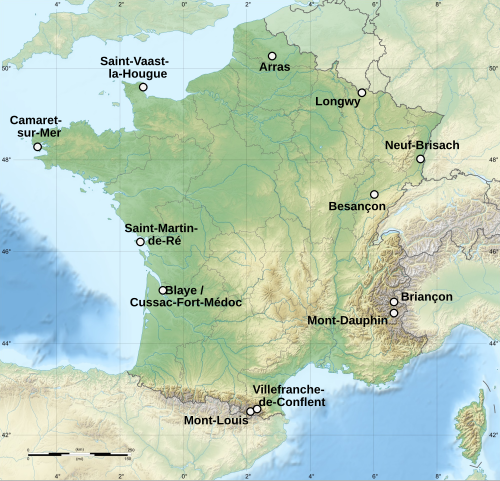
Map of Vauban's major places, in France.
Summary[edit]
| Description |
Deutsch: Karte der Festungsanlagen von Vauban in Frankreich, eingetragen auf der Welterbeliste der UNESCO.
English: Map of Vauban's major places, in France. They are part of UNESCO World Heritage list
Español: Mapa de los mayores fortificaciones de Vauban, en Francia.
Français : Carte du réseau des sites majeurs de Vauban, en France. Ces sites sont classés au patrimoine mondial de l'Unesco. |
||
| Date |
| ||
| Attribution (required by the license) | © Sémhur / Wikimedia Commons / | ||
| SVG development |
|
||
| Source |
|
||
| Author | Sémhur |

| Object location | | View this and other nearby images on: OpenStreetMap |
|---|
Licensing[edit]
I, the copyright holder of this work, hereby publish it under the following license:
This file is licensed under the Creative Commons Attribution-Share Alike Attribution-Share Alike 4.0 International, 3.0 Unported, 2.5 Generic, 2.0 Generic and 1.0 Generic license.
- You are free:
- to share – to copy, distribute and transmit the work
- to remix – to adapt the work
- Under the following conditions:
- attribution – You must give appropriate credit, provide a link to the license, and indicate if changes were made. You may do so in any reasonable manner, but not in any way that suggests the licensor endorses you or your use.
- share alike – If you remix, transform, or build upon the material, you must distribute your contributions under the same or compatible license as the original.
File history
Click on a date/time to view the file as it appeared at that time.
| Date/Time | Thumbnail | Dimensions | User | Comment | |
|---|---|---|---|---|---|
| current | 12:54, 28 January 2019 | | 1,996 × 1,918 (1.07 MB) | Sémhur (talk | contribs) | label "Breisach am Rhein" removed |
| 21:53, 24 July 2008 |  | 1,996 × 1,918 (1.07 MB) | Mozillaman (talk | contribs) | Removed border. | |
| 13:22, 18 July 2008 |  | 2,000 × 1,922 (1.07 MB) | Sémhur (talk | contribs) | Breisach am main removed | |
| 19:10, 7 July 2008 |  | 2,000 × 1,922 (1.07 MB) | Sémhur (talk | contribs) | Two places deleted - not on UNESCO World Heritage list | |
| 18:50, 7 July 2008 |  | 2,000 × 1,922 (1.07 MB) | Sémhur (talk | contribs) | {{Information |Description={{en|1=Map of the Vauban's major places, in France.}} {{fr|1=Carte des réseau des sites majeurs de Vauban, situé majoritairement en France.}} {{es|1=Mapa de los mayore |
You cannot overwrite this file.
File usage on Commons
There are no pages that use this file.
File usage on other wikis
The following other wikis use this file:
- Usage on cs.wikipedia.org
- Usage on de.wikipedia.org
- Usage on el.wikipedia.org
- Usage on en.wikipedia.org
- Usage on eo.wikipedia.org
- Usage on es.wikipedia.org
- Usage on fr.wikipedia.org
- Saint-Vaast-la-Hougue
- Longwy
- Briançon
- Saint-Martin-de-Ré
- Mont-Louis (Pyrénées-Orientales)
- Villefranche-de-Conflent
- Tatihou
- Neuf-Brisach
- Citadelle de Saint-Martin-de-Ré
- Fortifications de Vauban inscrites à l'Unesco
- Citadelle de Blaye
- Fort Libéria
- Fort des Salettes
- Pont d'Asfeld
- Fort du Randouillet
- Fort des Têtes
- Fort Médoc
- Mont-Dauphin
- Arras
- Fort Paté
- Wikipédia:Atelier graphique/Cartes/Archives/juillet 2008
- Tour Vauban (Camaret-sur-Mer)
- Projet:Impression/Wikigraphistes
- Modèle:Palette Réseau des sites majeurs de Vauban
- Tour de la Pelote
- Citadelle de Besançon
- Fort Griffon
- Enceinte de Longwy
- Citadelle d'Arras
- Forts de la Hougue et de Tatihou
- Fort du Mont-Dauphin
- Bastion du moulin Saint-Paul
- Usage on gl.wikipedia.org
- Usage on hr.wikipedia.org
- Usage on hu.wikipedia.org
- Usage on hy.wikipedia.org
- Usage on id.wikipedia.org
- Usage on it.wikipedia.org
View more global usage of this file.