File:Carte-topo Cret-Neige FR.svg
Jump to navigation
Jump to search

Size of this PNG preview of this SVG file: 800 × 543 pixels. Other resolutions: 320 × 217 pixels | 640 × 434 pixels | 1,024 × 695 pixels | 1,280 × 868 pixels | 2,560 × 1,737 pixels | 2,105 × 1,428 pixels.
Original file (SVG file, nominally 2,105 × 1,428 pixels, file size: 14.57 MB)
Captions
Captions
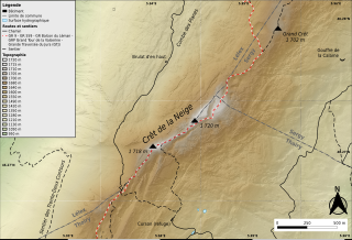
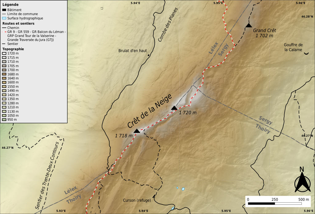
Topographic map of the crêt de la Neige summit and its area, in the Monts Jura (Ain, France).
Summary[edit]
| Description |
Français : Carte topographique détaillée du sommet du crêt de la Neige et de ses alentours dans la chaîne des Monts Jura, dans le Jura français.
Sources des données :
This W3C-unspecified vector image was created with QGIS. This W3C-unspecified vector image was created with Inkscape . |
||
| Date | |||
| Source | Own work | ||
| Author | Géodigital |
Licensing[edit]
I, the copyright holder of this work, hereby publish it under the following license:
This file is licensed under the Creative Commons Attribution-Share Alike 4.0 International license.
- You are free:
- to share – to copy, distribute and transmit the work
- to remix – to adapt the work
- Under the following conditions:
- attribution – You must give appropriate credit, provide a link to the license, and indicate if changes were made. You may do so in any reasonable manner, but not in any way that suggests the licensor endorses you or your use.
- share alike – If you remix, transform, or build upon the material, you must distribute your contributions under the same or compatible license as the original.
File history
Click on a date/time to view the file as it appeared at that time.
| Date/Time | Thumbnail | Dimensions | User | Comment | |
|---|---|---|---|---|---|
| current | 17:52, 26 August 2021 | | 2,105 × 1,428 (14.57 MB) | Géodigital (talk | contribs) | Uploaded own work with UploadWizard |
You cannot overwrite this file.
File usage on Commons
There are no pages that use this file.
File usage on other wikis
The following other wikis use this file:
- Usage on fr.wikipedia.org