Category:Topographic maps of the Jura mountains
Jump to navigation
Jump to search
Media in category "Topographic maps of the Jura mountains"
The following 16 files are in this category, out of 16 total.
-
 469x487-Carte-25-Doubs-R.jpg 469 × 487; 56 KB
-
 469x487-Carte-25-Doubs-R2.jpg 469 × 487; 63 KB
-
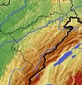
 Alps Jura He.jpg 888 × 546; 301 KB
-
 Carte Grand Cret Eau.svg 1,283 × 1,487; 348 KB
-
 Carte-topo Cret-Neige FR.svg 2,105 × 1,428; 14.57 MB
-
 Carte-topo Monts-Jura FR.svg 2,242 × 3,132; 12.92 MB
-
 Jura location map.png 3,234 × 3,055; 10.41 MB
-
 Jura topographic map-fr.png 7,971 × 4,088; 29.07 MB
-
 Jura TopoMap 2.png 654 × 531; 786 KB
-
 Jura TopoMap.png 654 × 531; 776 KB
-
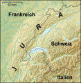 Lagekarte Jura.png 827 × 846; 1.36 MB
-
 MacizoDelJura.svg 730 × 638; 31.41 MB
-
 Plateau Grand-Ratz localisation.svg 960 × 860; 1.46 MB
-
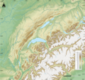
 Schweiz-Französischer-Jura (edit).jpg 529 × 499; 439 KB
-
 Schweiz-Französischer-Jura.png 888 × 546; 1.12 MB
-
 Topographie Besançon.svg 2,182 × 2,700; 737 KB


.jpg)

