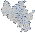
File:Cadastral map of Brno.svg
From Wikimedia Commons, the free media repository
Jump to navigation
Jump to search

Size of this PNG preview of this SVG file: 590 × 551 pixels. Other resolutions: 257 × 240 pixels | 514 × 480 pixels | 822 × 768 pixels | 1,097 × 1,024 pixels | 2,193 × 2,048 pixels.
Original file (SVG file, nominally 590 × 551 pixels, file size: 73 KB)
File information
Structured data
Captions
Captions
Add a one-line explanation of what this file represents
Summary[edit]
- Bohunice
- Bosonohy
- Brněnské Ivanovice
- Bystrc
- Černá Pole
- Černovice
- Dolní Heršpice
- Dvorska
- Holásky
- Horní Heršpice
- Husovice
- Chrlice
- Ivanovice
- Jehnice
- Jundrov
- Kníničky
- Kohoutovice
- Komárov
- Komín
- Královo Pole
- Lesná
- Líšeň
- Maloměřice
- Medlánky
- Město Brno
- Mokrá Hora
- Nový Lískovec
- Obřany
- Ořešín
- Pisárky
- Ponava
- Přízřenice
- Řečkovice
- Sadová
- Slatina
- Soběšice
- Staré Brno
- Starý Lískovec
- Stránice
- Štýřice
- Trnitá
- Tuřany
- Útěchov u Brna
- Veveří
- Zábrdovice
- Žabovřesky
- Žebětín
- Židenice
| DescriptionCadastral map of Brno.svg |
|
| Date | 2007 |
| Source | Based on GIS maps |
| Author | Frettie |
| Permission (Reusing this file) |
Public domain |
| Other versions | Derivative works of this file: Poloha katastrálneho územia Pisárky.svg |
Licensing[edit]
| Public domainPublic domainfalsefalse |
| I, the copyright holder of this work, release this work into the public domain. This applies worldwide. In some countries this may not be legally possible; if so: I grant anyone the right to use this work for any purpose, without any conditions, unless such conditions are required by law. |
File history
Click on a date/time to view the file as it appeared at that time.
| Date/Time | Thumbnail | Dimensions | User | Comment | |
|---|---|---|---|---|---|
| current | 21:45, 27 February 2009 |  | 590 × 551 (73 KB) | Kirk979 (talk | contribs) | corrections |
| 13:33, 13 February 2007 |  | 590 × 551 (70 KB) | Frettie (talk | contribs) | == Summary == {{Information |Description=*{{en|Cadastral map of Brno's cadastral areas in the en:Czech Republic.}} *{{cs|Katastrální mapa brněnských katastrálních území.}} |Source= Based on GIS maps |Date= 2007 | | |
| 00:15, 12 February 2007 |  | 590 × 551 (143 KB) | Frettie (talk | contribs) | {{Information |Description=*{{en|Cadastral map of Brno's cadastral areas in the en:Czech Republic.}} *{{cs|Katastrální mapa brněnských katastrálních území.}} |Source= Based on GIS maps |Date= 2007 |Author= [[:cs: |
You cannot overwrite this file.
File usage on Commons
The following 3 pages use this file:
File usage on other wikis
The following other wikis use this file:
- Usage on cs.wikipedia.org
- Usage on eo.wikipedia.org
- Usage on sk.wikipedia.org
Metadata
This file contains additional information such as Exif metadata which may have been added by the digital camera, scanner, or software program used to create or digitize it. If the file has been modified from its original state, some details such as the timestamp may not fully reflect those of the original file. The timestamp is only as accurate as the clock in the camera, and it may be completely wrong.
| Width | 589.70001 |
|---|---|
| Height | 551.47998 |