File:British Empire.png
Jump to navigation
Jump to search
Size of this preview: 800 × 351 pixels. Other resolutions: 320 × 140 pixels | 640 × 281 pixels | 1,425 × 625 pixels.
Original file (1,425 × 625 pixels, file size: 41 KB, MIME type: image/png)
Captions
Captions
Add a one-line explanation of what this file represents
Summary[edit]
| Description |
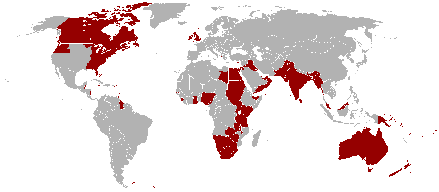
English: Map of all the offical territorial claims of the British Empire that it ever held. (Do keep in mind that Oregon Territory was shared with the United States and south-east Libya was shared with Italy in a disputed part of what was then known as Italian North Africa). |
| Date | 2 January 2005 (original upload date) |
| Source | Information gathered throughout the English Wikipedia |
| Author | Ramirez72, Andersmusician, Vadac |
| Permission (Reusing this file) |
Released into the public domain (by the author). |
Licensing[edit]
This file is licensed under the Creative Commons Attribution-Share Alike 2.5 Generic license.
- You are free:
- to share – to copy, distribute and transmit the work
- to remix – to adapt the work
- Under the following conditions:
- attribution – You must give appropriate credit, provide a link to the license, and indicate if changes were made. You may do so in any reasonable manner, but not in any way that suggests the licensor endorses you or your use.
- share alike – If you remix, transform, or build upon the material, you must distribute your contributions under the same or compatible license as the original.
File history
Click on a date/time to view the file as it appeared at that time.
| Date/Time | Thumbnail | Dimensions | User | Comment | |
|---|---|---|---|---|---|
| current | 08:16, 31 October 2021 | | 1,425 × 625 (41 KB) | Randomastwritter (talk | contribs) | jubaland |
| 01:16, 14 December 2010 |  | 1,425 × 625 (51 KB) | Vadac (talk | contribs) | Clearer version which includes a huge amount of missing territory in the western region of British America which was part of the British Empire from 1763-1783. | |
| 01:05, 2 January 2005 |  | 1,357 × 628 (24 KB) | Nickshanks (talk | contribs) | Territories once under administration from London. Excludes parts of France (not sure what to include), British Antarctic Territories, and many small Pacific and Indian Ocean islands. {{PD}} |
You cannot overwrite this file.
File usage on Commons
The following page uses this file:
File usage on other wikis
The following other wikis use this file:
- Usage on da.wikipedia.org
- Usage on en.wikipedia.org
- Usage on he.wikipedia.org
- Usage on nn.wikipedia.org
- Usage on no.wikipedia.org