File:Breuschstellung-map-fr.svg
Jump to navigation
Jump to search

Size of this PNG preview of this SVG file: 538 × 600 pixels. Other resolutions: 215 × 240 pixels | 431 × 480 pixels | 689 × 768 pixels | 919 × 1,024 pixels | 1,837 × 2,048 pixels | 1,047 × 1,167 pixels.
Original file (SVG file, nominally 1,047 × 1,167 pixels, file size: 497 KB)
Captions
Captions
Add a one-line explanation of what this file represents
Summary[edit]
| Description |
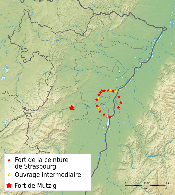
Français : Carte de la ceinture fortifiée de Strasbourg y compris le fort de Mutzig, l'ensemble constituant au début de la Première Guerre mondiale la ligne de défense allemande sur la Bruche (Breuschstellung). English: Map of the fortified belt of Strasbourg including the Fort of Mutzig, the whole being at the beginning of the First World War the German defense line on the Bruche River (Breuschstellung). Deutsch: Karte von die Festen der Grossfestung Strassburg einschliesslich die Feste Kaiser Wilhelm II. (fr. fort de Mutzig), das Ganze war am Anfang des ersten Weltkrieges die deutsche Abwehrlinie an der Breusch (fr. Bruche), auch als Breuschstellung gekannt. Magyar: Strasbourg megerősített erődgyűrűje a mutzigi erőddel, az Első Világháború elején német védelmi vonal a Brouche folyónál (Breuschstellung). |
| Date | |
| Source | derivated from File:Bas-Rhin department location map.svg and File:Bas-Rhin_department_relief_location_map.jpg, works by Eric Gaba (Sting - fr:Sting) |
| Author | Papatt |
| Other versions | German, English and Hungarian versions |
| SVG development |

Licensing[edit]
I, the copyright holder of this work, hereby publish it under the following license:
This file is licensed under the Creative Commons Attribution-Share Alike 3.0 Unported license.
- You are free:
- to share – to copy, distribute and transmit the work
- to remix – to adapt the work
- Under the following conditions:
- attribution – You must give appropriate credit, provide a link to the license, and indicate if changes were made. You may do so in any reasonable manner, but not in any way that suggests the licensor endorses you or your use.
- share alike – If you remix, transform, or build upon the material, you must distribute your contributions under the same or compatible license as the original.
File history
Click on a date/time to view the file as it appeared at that time.
| Date/Time | Thumbnail | Dimensions | User | Comment | |
|---|---|---|---|---|---|
| current | 21:15, 9 October 2011 | | 1,047 × 1,167 (497 KB) | Papatt (talk | contribs) | cadre de la légende agrandi |
| 21:09, 9 October 2011 |  | 1,047 × 1,167 (497 KB) | Papatt (talk | contribs) | + un fort en Allemagne et trois ouvrages en France ; différenciation fort/ouvrage | |
| 22:24, 8 October 2011 |  | 1,047 × 1,167 (537 KB) | Papatt (talk | contribs) | cadre de la légende agrandi ; position du fort de Mutzig affinée | |
| 19:52, 8 October 2011 |  | 1,047 × 1,167 (537 KB) | Sting (talk | contribs) | Corrected SVG ; with physical background as requested by author | |
| 18:23, 8 October 2011 |  | 1,047 × 1,167 (413 KB) | Papatt (talk | contribs) | Lisibilté de la légende | |
| 18:17, 8 October 2011 |  | 1,047 × 1,167 (413 KB) | Papatt (talk | contribs) |
You cannot overwrite this file.
File usage on Commons
The following page uses this file:
- File:Breuschstellung.svg (file redirect)
File usage on other wikis
The following other wikis use this file:
- Usage on fr.wikipedia.org