File:Bowles's new pocket map of the United States of America; the British possessions of Canada, Nova Scotia, and Newfoundland, with the French and Spanish territories of Louisiana and Florida, as settled LOC gm71005456.tif
Jump to navigation
Jump to search

Size of this JPG preview of this TIF file: 652 × 600 pixels. Other resolutions: 261 × 240 pixels | 522 × 480 pixels | 835 × 768 pixels | 1,113 × 1,024 pixels | 2,227 × 2,048 pixels | 6,275 × 5,771 pixels.
Original file (6,275 × 5,771 pixels, file size: 103.61 MB, MIME type: image/tiff)
Captions
Captions
Add a one-line explanation of what this file represents
Summary[edit]
| Description |
English: Scale ca. 1:6,500,000. Hand colored. Relief shown pictorially. Prime meridian: Ferro and London. Includes historic notes, listing of "The 13 United States of America," and inset "Article III." LC Maps of North America, 1750-1789, 745 Available also through the Library of Congress Web site as a raster image. Vault AACR2 Copy 1 has land areas colored in pink, yellow, and green. Copy 2 has land areas colored in pink, yellow, and green; some boundaries in red; New England States colored as one. Copy 3 has land areas colored in brown; boundaries in green. |
||
| Title | Bowles's new pocket map of the United States of America; the British possessions of Canada, Nova Scotia, and Newfoundland, with the French and Spanish territories of Louisiana and Florida, as settled by the preliminary articles of peace signed at Versailles the 20th. Jany. 1783. | ||
| Shelf ID | G3700 1783 .B64 | ||
| Date | |||
| Source | https://www.loc.gov/item/gm71005456/ | ||
| Author | Bowles, Carington | ||
| Permission (Reusing this file) |
|
||
| Other versions |
|
||
| Location | United States · Canada | ||
| Part of | Military Battles And Campaigns · American Memory · Catalog · Geography And Map Division · American Revolution And Its Era: Maps And Charts Of North America And The West Indies, 1750-1789 | ||
| Subject | United States · Maps · Early Works To 1800 · Canada |


Licensing[edit]
|
This is a faithful photographic reproduction of a two-dimensional, public domain work of art. The work of art itself is in the public domain for the following reason:
The official position taken by the Wikimedia Foundation is that "faithful reproductions of two-dimensional public domain works of art are public domain".
This photographic reproduction is therefore also considered to be in the public domain in the United States. In other jurisdictions, re-use of this content may be restricted; see Reuse of PD-Art photographs for details. | ||||
File history
Click on a date/time to view the file as it appeared at that time.
| Date/Time | Thumbnail | Dimensions | User | Comment | |
|---|---|---|---|---|---|
| current | 02:30, 2 June 2018 | 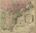 | 6,275 × 5,771 (103.61 MB) | Fæ (talk | contribs) | LOC Maps https://www.loc.gov/item/gm71005456/ #17619 |
You cannot overwrite this file.
File usage on Commons
The following page uses this file: