File:Bouvet Island relief location map.svg
Jump to navigation
Jump to search

Size of this PNG preview of this SVG file: 791 × 600 pixels. Other resolutions: 317 × 240 pixels | 633 × 480 pixels | 1,013 × 768 pixels | 1,280 × 971 pixels | 2,560 × 1,942 pixels | 1,693 × 1,284 pixels.
Original file (SVG file, nominally 1,693 × 1,284 pixels, file size: 699 KB)
Captions
Captions
Add a one-line explanation of what this file represents
Summary[edit]
| Camera location | | View this and other nearby images on: OpenStreetMap |
|---|
| Description |
Deutsch: Relief Positionskarte von Bouvetinsel
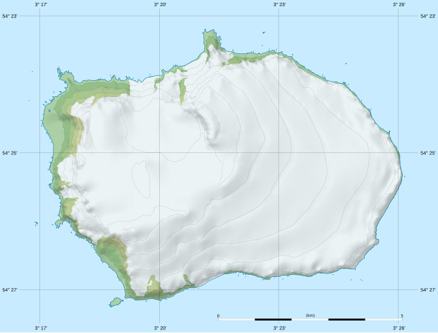
English: Blank relief location map of Bouvet Island
Français : Carte physique vierge de l’île Bouvet, destinée à la géolocalisation. Scale: 1:80,000 (precision: 20 m for the topography and ground features)
Geographic limits of the map:
|
|||||||||
| Date | ||||||||||
| Source | data: Norwegian Polar Institute (modified for the shaded relief) (under CC-BY 4.0) | |||||||||
| Author | Eric Gaba (Sting - fr:Sting) | |||||||||
| Permission (Reusing this file) |
|
|||||||||
| Other versions |
|
|||||||||

Licensing[edit]
I, the copyright holder of this work, hereby publish it under the following license:
This file is licensed under the Creative Commons Attribution-Share Alike 4.0 International license.
- You are free:
- to share – to copy, distribute and transmit the work
- to remix – to adapt the work
- Under the following conditions:
- attribution – You must give appropriate credit, provide a link to the license, and indicate if changes were made. You may do so in any reasonable manner, but not in any way that suggests the licensor endorses you or your use.
- share alike – If you remix, transform, or build upon the material, you must distribute your contributions under the same or compatible license as the original.
File history
Click on a date/time to view the file as it appeared at that time.
| Date/Time | Thumbnail | Dimensions | User | Comment | |
|---|---|---|---|---|---|
| current | 21:45, 17 February 2020 | | 1,693 × 1,284 (699 KB) | Sting (talk | contribs) | == {{int:filedesc}} == {{Location|54|25|00|S|003|21|00|E|scale:100000}} {{Information |Description= {{de|Relief Positionskarte von Bouvetinsel}} {{en|Blank relief location map of Bouvet Island}} {{fr|Carte physique vierge de l’île Bouvet, destinée à la géolocalisation.}}<br/> Scale: 1:80,000 (precision: 20 m for the topography and ground features)<br/> Equirectangular projection, WGS84 datum<br/> *Standard meridian: 003.35835° E<br... |
You cannot overwrite this file.
File usage on Commons
The following 4 pages use this file:
File usage on other wikis
The following other wikis use this file:
- Usage on cs.wikipedia.org
- Usage on de.wikipedia.org
- Kap Circoncision
- Benutzer:Carport/Bouvetøya
- Vorlage:Positionskarte Bouvetinsel
- Posadowsky-Gletscher (Bouvetinsel)
- Kap Fie
- Christensen-Gletscher (Bouvetinsel)
- Horntvedt-Gletscher
- Morrell-Riff
- Røverhullet
- Sachsebåane
- Morgenstierne-Küste
- Victoria-Terrasse-Küste
- Mowinckel-Küste
- Vogt-Küste
- Esmarch-Küste
- Engelbrecht-Gletscher
- Randibreen
- Slakhallet
- Westwindstranda
- Selstranda
- Sjøelefantstranda
- Svartstranda
- Smalstranda
- Aagaardbreen
- Kraterisen
- Selbadet
- Usage on en.wikipedia.org
- Usage on eo.wikipedia.org
- Usage on fr.wikipedia.org
- Usage on mn.wikipedia.org
- Usage on no.wikipedia.org
- Usage on si.wikipedia.org
- Usage on uz.wikipedia.org