File:Bernina range as seen from Piz Campagnung.jpg
Jump to navigation
Jump to search
Size of this preview: 800 × 600 pixels. Other resolutions: 320 × 240 pixels | 640 × 480 pixels | 1,024 × 768 pixels | 1,280 × 960 pixels | 2,560 × 1,920 pixels | 4,608 × 3,456 pixels.
Original file (4,608 × 3,456 pixels, file size: 8.35 MB, MIME type: image/jpeg)
Captions
Captions
Add a one-line explanation of what this file represents
Summary[edit]
| Description |
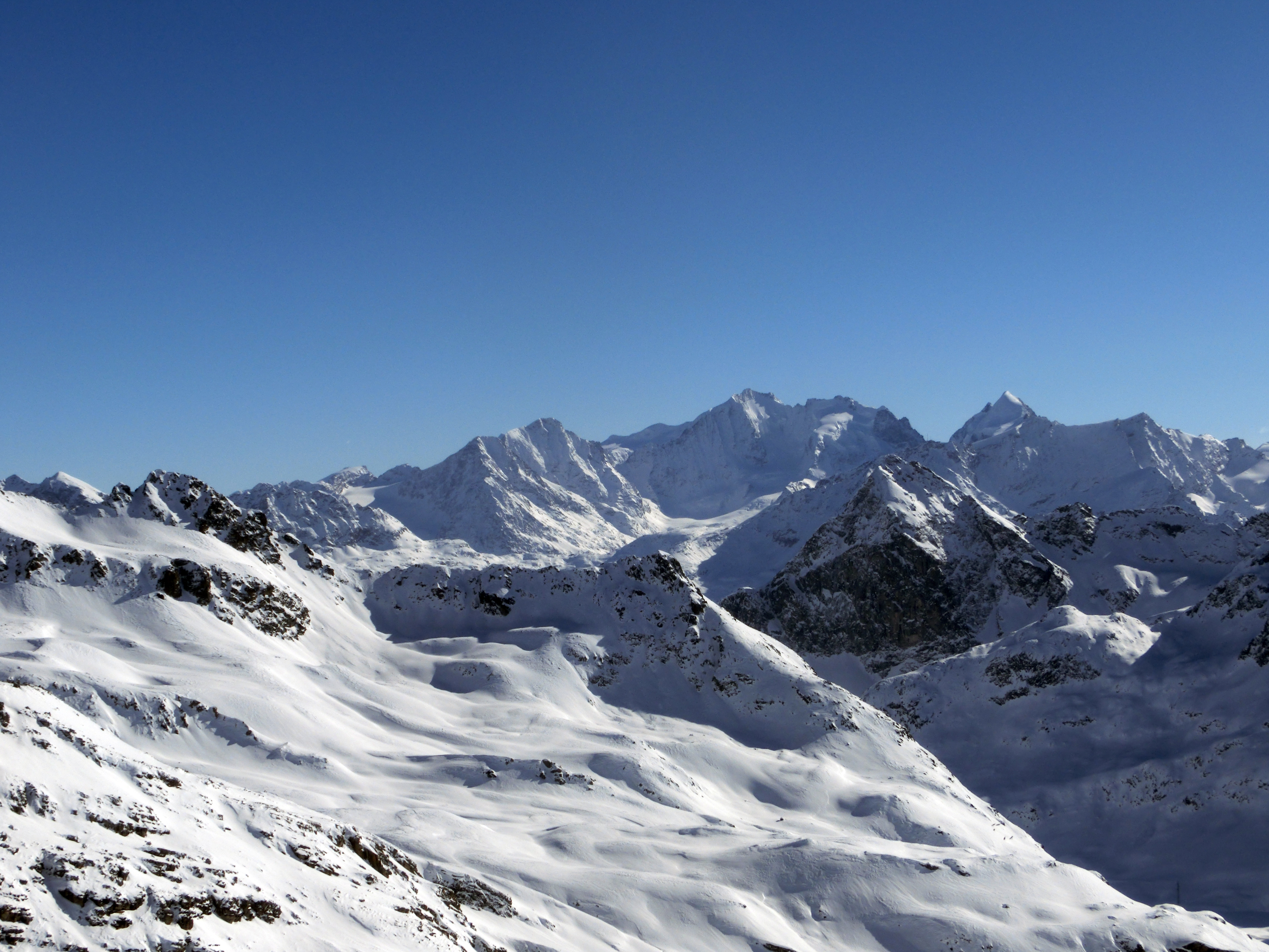
English: From left to right: Piz Surlej, Piz Arlas, Munt Arlas, Crasta da Boval, Piz Boval, Piz Cambrna, Piz Tschierva, Piz Morteratsch, in the background Piz Privlus, Bellavista, in the foreground more prominent Pizzo Bianco, Piz Bernina, La Spedla, Piz Umur, Piz Scerscen, on the ridge the mountain station of Corvatsch, in the background Schneekuppe, in the foreground Piz Mortèl und Piz Corvatsch as seen from Piz Campagnung (Bivio, Marmorera), Grison, Switzerland
Deutsch: Von links nach rachts: Piz Surlej, Piz Arlas, Munt Arlas, Crasta da Boval, Piz Boval, Piz Cambrna, Piz Tschierva, Piz Morteratsch, dahinter Piz Privlus, Bellavista, vorne markant Pizzo Bianco, Piz Bernina, La Spedla, Piz Umur, Piz Scerscen, auf dem Grad die Bergstation von Corvatsch, dahinter Schneekuppe, vorne Piz Mortèl und Piz Corvatsch, aufgenommen vom Piz Campagnung (Bivio, Marmorera), Graubünden, Schweiz
Rumantsch: Da sanester a dretg: Piz Surlej, Piz Arlas, Munt Arlas, Crasta da Boval, Piz Boval, Piz Cambrna, Piz Tschierva, Piz Morteratsch, davos ve Piz Privlus, Bellavista, davant marcant Pizzo Bianco, Piz Bernina, La Spedla, Piz Umur, Piz Scerscen, segl feil la staziun da munt digl Corvatsch, davos ve Schneekuppe, davant Piz Mortèl e Piz Corvatsch, piglia se digl Piz Campagnung (Beiva, Marmorera), Grischun, Svizra
Italiano: Da sinistra a destra: Piz Surlej, Piz Arlas, Munt Arlas, Crasta da Boval, Piz Boval, Piz Cambrna, Piz Tschierva, Piz Morteratsch, dietro Piz Privlus, Bellavista, in evidenza sul davanti Pizzo Bianco, Piz Bernina, La Spedla, Piz Umur, Piz Scerscen, sulla cresta la stazione di montagna del Corvatsch, dietro Schneekuppe, davanti Piz Mortèl e Piz Corvatsch, fotografati dal Piz Campagnung (Bivio, Marmorera), Grigioni, Svizzera |
|
| Date | ||
| Source | Own work | |
| Author | Capricorn4049 | |
| Permission (Reusing this file) |
|
| Camera location | | View this and other nearby images on: OpenStreetMap |
|---|
Licensing[edit]
This file is licensed under the Creative Commons Attribution-Share Alike 4.0 International license.
- You are free:
- to share – to copy, distribute and transmit the work
- to remix – to adapt the work
- Under the following conditions:
- attribution – You must give appropriate credit, provide a link to the license, and indicate if changes were made. You may do so in any reasonable manner, but not in any way that suggests the licensor endorses you or your use.
- share alike – If you remix, transform, or build upon the material, you must distribute your contributions under the same or compatible license as the original.
File history
Click on a date/time to view the file as it appeared at that time.
| Date/Time | Thumbnail | Dimensions | User | Comment | |
|---|---|---|---|---|---|
| current | 22:07, 8 February 2015 | | 4,608 × 3,456 (8.35 MB) | Capricorn4049 (talk | contribs) |
You cannot overwrite this file.
File usage on Commons
The following page uses this file:
File usage on other wikis
The following other wikis use this file:
- Usage on cs.wikipedia.org
- Usage on de.wikipedia.org