File:Berlin Martin Gropiusbau Front.jpg

Original file (2,048 × 1,536 pixels, file size: 547 KB, MIME type: image/jpeg)
Captions
Captions
Summary
Object
| Martin-Gropius-Bau
|
||||||||||||||||||||||||||||||||||||||||
|---|---|---|---|---|---|---|---|---|---|---|---|---|---|---|---|---|---|---|---|---|---|---|---|---|---|---|---|---|---|---|---|---|---|---|---|---|---|---|---|---|
| Architect |
|
 | ||||||||||||||||||||||||||||||||||||||
| Title |
Martin-Gropius-Bau |
|||||||||||||||||||||||||||||||||||||||
| Object type |
museum / museum building / movie theater |
|||||||||||||||||||||||||||||||||||||||
| Description |
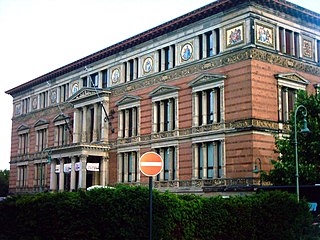
Cette construction a été conçue par les architectes : Martin Gropius (le grand-oncle de l'architecte Walter Gropius, le fondateur du Bauhaus) et Heino Schmieden pour le musée des arts décoratifs de l'époque. Le style du bâtiment, qui est construit autour d'un vaste atrium couvert d'une verrière, relève de l'école du grand architecte prussien Karl Friedrich Schinkel (1781-1841). Les décors sur la façade évoquent les métiers d'art et les buts de ces activités décoratives. Très dégradé par les bombardements de la guerre, puis situé tout près du mur, il a été reconstruit en 1981 et aménagé en 1999. Il est aujourd'hui dédié aux expositions d'art temporaires. Deutsch: Der Martin-Gropius-Bau in Berlin Kreuzberg, Niederkirchnerstraße. Ehemaliges Kunstgewerbemuseum, heute als Ausstellungsgebäude genutzt. Gesamtansicht.
|
|||||||||||||||||||||||||||||||||||||||
| Date |
1881 |
|||||||||||||||||||||||||||||||||||||||
| Collection | ||||||||||||||||||||||||||||||||||||||||
| Object location |
|
|||||||||||||||||||||||||||||||||||||||
| References | ||||||||||||||||||||||||||||||||||||||||
| Authority file | ||||||||||||||||||||||||||||||||||||||||
.jpg)

Photograph
| Date | |||||||||
| Source | de.wikipedia.org: 22:36, 19. Jun. 2005 . . Jensen . . 2048 x 1536 (774.133 Bytes) (Gesamtansicht Martin Gropius Bau vom 2005-06-19 Fotograf: Jens Lordan Dateistatus: GNU FDL) | ||||||||
| Author |
Jensen at the German-language Wikipedia, the copyright holder of this work, hereby publishes it under the following license:
|

| Camera location | | View this and other nearby images on: OpenStreetMap |
|---|
Licensing
- You are free:
- to share – to copy, distribute and transmit the work
- to remix – to adapt the work
- Under the following conditions:
- attribution – You must give appropriate credit, provide a link to the license, and indicate if changes were made. You may do so in any reasonable manner, but not in any way that suggests the licensor endorses you or your use.
- share alike – If you remix, transform, or build upon the material, you must distribute your contributions under the same or compatible license as the original.
File history
Click on a date/time to view the file as it appeared at that time.
| Date/Time | Thumbnail | Dimensions | User | Comment | |
|---|---|---|---|---|---|
| current | 05:54, 31 October 2006 | | 2,048 × 1,536 (547 KB) | BLueFiSH.as (talk | contribs) | Auf eine alte Version zurückgesetzt |
| 05:54, 31 October 2006 |  | 2,048 × 1,536 (756 KB) | BLueFiSH.as (talk | contribs) | original image version from de:Bild:Gropiusbau1.jpg by Jensen | |
| 22:46, 26 October 2006 |  | 2,048 × 1,536 (547 KB) | Unify~commonswiki (talk | contribs) | {{Information |Description=Martin Gropius Bau, Berlin (Farbe korrigiert) |Source=eigene Bearbeitung |Date=2006 |Author=Jens Lordan, original |Permission=GNU |other_versions= }} |
You cannot overwrite this file.
File usage on Commons
The following page uses this file:
File usage on other wikis
The following other wikis use this file:
- Usage on de.wikipedia.org
- Usage on en.wikipedia.org
- Usage on en.wikivoyage.org
- Usage on nl.wikipedia.org
- Usage on pl.wikipedia.org
- Usage on pt.wikipedia.org