File:Bering Strait ESA390553.tiff

Original file (15,000 × 10,016 pixels, file size: 390.8 MB, MIME type: image/tiff)
Captions
Captions
Summary[edit]
| Warning | The original file is very high-resolution. It might not load properly or could cause your browser to freeze when opened at full size. |
|---|
| Description |
English: The Copernicus Sentinel-1 mission takes us over the Bering Strait, which connects the Pacific and Arctic Oceans between Russia and the US state of Alaska.
The image was created by combining three radar scans of 11 December 2017, 23 December 2017 and 4 January 2018. Each image has been assigned a different colour: blue, red and green, respectively. This creates a colourful composite that highlights how the sea ice changed over the four weeks. Since the Bering Strait lies slightly south of the polar circle, days are short during the winter. Thanks to its radar, Sentinel-1 can ‘see’ through clouds and in the dark, making it especially valuable for monitoring parts of the planet that endure relatively dark winter months. Offering this ‘radar vision’, images from Sentinel-1 can be used for charting icebergs and for generating maps of sea ice for year-round navigation. Additionally, monitoring changes in the extent of sea ice is critical for understanding the effect of climate change on our environment. It has been reported that sea ice in the Bering Strait has been particularly low this winter. This is because unusually warm water streamed up from the south, causing some of the sea ice to melt earlier than usual. As a result, areas that would have remained covered with reflective sea ice were open for much longer. The relatively dark surface of the sea was able to absorb a lot of energy from the Sun, which prevented sea ice forming in the autumn. Also, recent storms have helped to break up much of the sea ice that did manage to form. This image is also featured on theEarth from Space video programme. |
| Date | |
| Source | http://www.esa.int/spaceinimages/Images/2018/02/Bering_Strait |
| Author | European Space Agency |
| Permission (Reusing this file) |
contains modified Copernicus Sentinel data (2017–18), processed by ESA,CC BY-SA 3.0 IGO |
| Other versions |
|
| Title | Bering Strait |
| System | Copernicus |
| Set | Earth observation image of the week |
| Mission | Sentinel-1 |
| Activity | Observing the Earth |

Licensing[edit]
- You are free:
- to share – to copy, distribute and transmit the work
- to remix – to adapt the work
- Under the following conditions:
- attribution – You must give appropriate credit, provide a link to the license, and indicate if changes were made. You may do so in any reasonable manner, but not in any way that suggests the licensor endorses you or your use.
- share alike – If you remix, transform, or build upon the material, you must distribute your contributions under the same or compatible license as the original.

|
This image contains data from a satellite in the Copernicus Programme, such as Sentinel-1, Sentinel-2 or Sentinel-3. Attribution is required when using this image.
Attribution: Contains modified Copernicus Sentinel data {{{year}}}
The use of Copernicus Sentinel Data is regulated under EU law (Commission Delegated Regulation (EU) No 1159/2013 and Regulation (EU) No 377/2014). Relevant excerpts:
Free access shall be given to GMES dedicated data [...] made available through GMES dissemination platforms [...].
Access to GMES dedicated data [...] shall be given for the purpose of the following use in so far as it is lawful:
GMES dedicated data [...] may be used worldwide without limitations in time.
GMES dedicated data and GMES service information are provided to users without any express or implied warranty, including as regards quality and suitability for any purpose. |
File history
Click on a date/time to view the file as it appeared at that time.
| Date/Time | Thumbnail | Dimensions | User | Comment | |
|---|---|---|---|---|---|
| current | 16:56, 23 February 2018 | 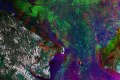 | 15,000 × 10,016 (390.8 MB) | Fæ (talk | contribs) | European Space Agency, Id 390553, http://www.esa.int/spaceinimages/Images/2018/02/Bering_Strait, User:Fæ/Project_list/ESA |
You cannot overwrite this file.
File usage on Commons
The following 2 pages use this file: