File:Bay of Bengal map de.svg
Jump to navigation
Jump to search

Size of this PNG preview of this SVG file: 605 × 599 pixels. Other resolutions: 242 × 240 pixels | 485 × 480 pixels | 775 × 768 pixels | 1,034 × 1,024 pixels | 2,068 × 2,048 pixels | 1,662 × 1,646 pixels.
Original file (SVG file, nominally 1,662 × 1,646 pixels, file size: 508 KB)
Captions
Captions
Add a one-line explanation of what this file represents
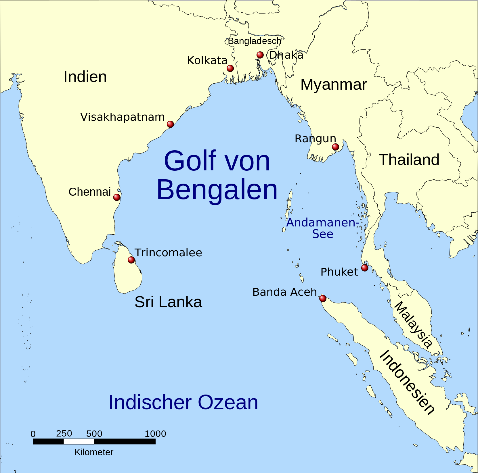
| Description | A map showing the location of the Bay of Bengal and the Andaman Sea in southeast Asia. |
| Date | (UTC) |
| Source | |
| Author |
|
| Other versions |
|


| This is a retouched picture, which means that it has been digitally altered from its original version. Modifications: Vector version, Tamil. The original can be viewed here: Red pog.svg:
|

|
This map has been made or improved in the German Kartenwerkstatt (Map Lab). You can propose maps to improve as well.
|

|
This SVG file contains embedded text that can be translated into your language, using any capable SVG editor, text editor or the SVG Translate tool. For more information see: About translating SVG files. |

|
Permission is granted to copy, distribute and/or modify this document under the terms of the GNU Free Documentation License, Version 1.2 or any later version published by the Free Software Foundation; with no Invariant Sections, no Front-Cover Texts, and no Back-Cover Texts. A copy of the license is included in the section entitled GNU Free Documentation License. |
| This file is licensed under the Creative Commons Attribution-Share Alike 3.0 Unported license. | ||
| ||
| This licensing tag was added to this file as part of the GFDL licensing update. |
Original upload log[edit]
This image is a derivative work of the following images:
- Image:Bay_of_Bengal_map.png licensed with GFDL
- 2006-02-06T14:47:19Z NormanEinstein 1000x1019 (349850 Bytes) Corrected typo.
- 2005-09-15T20:33:04Z NormanEinstein 800x814 (268248 Bytes) A map showing the location of the Bay of Bengal and the Andaman Sea in southeast Asia. Created by NormanEinstein, September 15, 2005. {{GFDL-self}} [[Category:Maps of Seas]]
- Image:Asia98.svg licensed with PD-USGov
- 2007-10-23T04:49:13Z Brianski 8000x4390 (9380412 Bytes) == NOTE! == This file is very large. It takes >2GB of memory just to open it in inkscape. == Summary == {{Information |Description=Map of Asia as of 1998, with first level administrative units. See also [[:Image:World98.svg]
- Image:Red_pog.svg licensed with PD-self
- 2006-11-23T04:33:54Z Andux 64x64 (607 Bytes) Reverted to earlier revision
- 2006-11-19T18:20:08Z Minestrone 10x10 (16830 Bytes) '
- 2006-11-19T18:18:25Z Minestrone 10x10 (16830 Bytes) radial gradient added to fill to give 3d effect (see: [[:en:Image:Locator Dot.svg]])
- 2006-06-26T09:07:26Z Andux 64x64 (607 Bytes) a little brighter
- 2006-06-26T08:35:17Z Andux 64x64 (607 Bytes) Shiny red button/marker widget. [[Category:Icons]][[Category:Buttons]]
|Permission= |other_versions= }}
| This is a retouched picture, which means that it has been digitally altered from its original version. Modifications: translation. The original can be viewed here: Bay of Bengal map ta.svg:
|
I, the copyright holder of this work, hereby publish it under the following license:
|
|
Permission is granted to copy, distribute and/or modify this document under the terms of the GNU Free Documentation License, Version 1.2 or any later version published by the Free Software Foundation; with no Invariant Sections, no Front-Cover Texts, and no Back-Cover Texts. A copy of the license is included in the section entitled GNU Free Documentation License. |
Original upload log[edit]
This image is a derivative work of the following images:
- File:Bay_of_Bengal_map_ta.svg licensed with GFDL
- 2008-09-22T08:14:10Z Trengarasu 1662x1646 (523092 Bytes) {{Information |Description=A map showing the location of the Bay of Bengal and the Andaman Sea in southeast Asia. |Source=*[[:Image:Bay_of_Bengal_map.png|]] *[[:Image:Asia98.svg|]] *[[:Image:Red_pog.svg|]] |Date=2008-09-22 08
Uploaded with derivativeFX
File history
Click on a date/time to view the file as it appeared at that time.
| Date/Time | Thumbnail | Dimensions | User | Comment | |
|---|---|---|---|---|---|
| current | 10:03, 3 January 2016 | | 1,662 × 1,646 (508 KB) | Furfur (talk | contribs) | moved Dhaka and Kolkata more to the North |
| 19:27, 21 February 2009 |  | 1,662 × 1,646 (515 KB) | Bamse (talk | contribs) | Indonesien | |
| 17:58, 21 February 2009 |  | 1,662 × 1,646 (515 KB) | Bamse (talk | contribs) | {{Information |Description=A map showing the location of the Bay of Bengal and the Andaman Sea in southeast Asia. |Source=*File:Bay_of_Bengal_map_ta.svg |Date=2009-02-21 17:56 (UTC) |Author=*File:Bay_of_Bengal_map_ta.svg: *derivative work: [[U |
You cannot overwrite this file.
File usage on Commons
The following 4 pages use this file:
File usage on other wikis
The following other wikis use this file:
- Usage on als.wikipedia.org
- Usage on de.wikipedia.org
- Usage on de.wiktionary.org
- Usage on frr.wikipedia.org
- Usage on nl.wikipedia.org
- Usage on pl.wiktionary.org
- Usage on uk.wikipedia.org