File:BRIDGE, NORTH OF COMPLEX, NORTH OF HOSPITAL ON NOME-BELTZ ROAD - Hammon Consolidated Gold Fields, Nome, Nome Census Area, AK HAER AK,14-NOME,1-21 (CT).tif
Jump to navigation
Jump to search

Size of this JPG preview of this TIF file: 754 × 599 pixels. Other resolutions: 302 × 240 pixels | 604 × 480 pixels | 966 × 768 pixels | 1,280 × 1,017 pixels | 2,560 × 2,035 pixels | 4,725 × 3,756 pixels.
Original file (4,725 × 3,756 pixels, file size: 50.78 MB, MIME type: image/tiff)
Captions
Captions
Add a one-line explanation of what this file represents
Summary[edit]
| BRIDGE, NORTH OF COMPLEX, NORTH OF HOSPITAL ON NOME-BELTZ ROAD - Hammon Consolidated Gold Fields, Nome, Nome Census Area, AK | ||||
|---|---|---|---|---|
| Title |
BRIDGE, NORTH OF COMPLEX, NORTH OF HOSPITAL ON NOME-BELTZ ROAD - Hammon Consolidated Gold Fields, Nome, Nome Census Area, AK |
|||
| Medium | 4 x 5 in. | |||
| Current location |
Library of Congress Prints and Photographs Division Washington, D.C. 20540 USA http://hdl.loc.gov/loc.pnp/pp.print |
|||
| Accession number |
HAER AK,14-NOME,1-21 (CT) |
|||
| Place of creation | Alaska; Nome Census Area; Nome | |||
| Credit line |
|
|||
| Source/Photographer | https://www.loc.gov/pictures/item/ak0008.color.571862c | |||
| Permission (Reusing this file) |
|
|||

| Camera location | | View this and other nearby images on: OpenStreetMap |
|---|
File history
Click on a date/time to view the file as it appeared at that time.
| Date/Time | Thumbnail | Dimensions | User | Comment | |
|---|---|---|---|---|---|
| current | 19:13, 24 June 2014 | 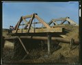 | 4,725 × 3,756 (50.78 MB) | Fæ (talk | contribs) | GWToolset: Creating mediafile for Fæ. HABS batch uploads start 24 June 2014 |
You cannot overwrite this file.
File usage on Commons
The following page uses this file: