File:BP OilSpill FisheryClosureMap 062110.pdf
Jump to navigation
Jump to search
Size of this JPG preview of this PDF file: 761 × 600 pixels. Other resolutions: 305 × 240 pixels | 609 × 480 pixels | 974 × 768 pixels | 1,280 × 1,009 pixels | 1,625 × 1,281 pixels.
Original file (1,625 × 1,281 pixels, file size: 783 KB, MIME type: application/pdf)
Captions
Captions
Add a one-line explanation of what this file represents
Summary[edit]
| Description |
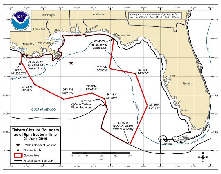
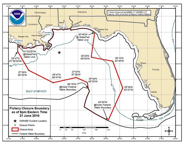
English: NOAA map of federal waters closed to fishing after the Deepwater Horizon oil spill as of June 21, 2011(near the maximum closure area.) |
| Date | |
| Source | NOAA website http://sero.nmfs.noaa.gov/ClosureInformation.htm accessed 17082011 |
| Author | National Oceanic and Atmospheric Administration |
Licensing[edit]
This image is in the public domain because it contains materials that originally came from the U.S. National Oceanic and Atmospheric Administration, taken or made as part of an employee's official duties.
|
File history
Click on a date/time to view the file as it appeared at that time.
| Date/Time | Thumbnail | Dimensions | User | Comment | |
|---|---|---|---|---|---|
| current | 19:22, 18 July 2011 |  | 1,625 × 1,281 (783 KB) | Geeklikepi (talk | contribs) |
You cannot overwrite this file.
File usage on Commons
There are no pages that use this file.
File usage on other wikis
The following other wikis use this file:
- Usage on en.wikipedia.org
- Usage on gl.wikipedia.org
- Usage on simple.wikipedia.org