File:Australian forest cover.tif

Original file (3,508 × 2,480 pixels, file size: 8.3 MB, MIME type: image/tiff)
Captions
Captions
Summary[edit]
| Description |
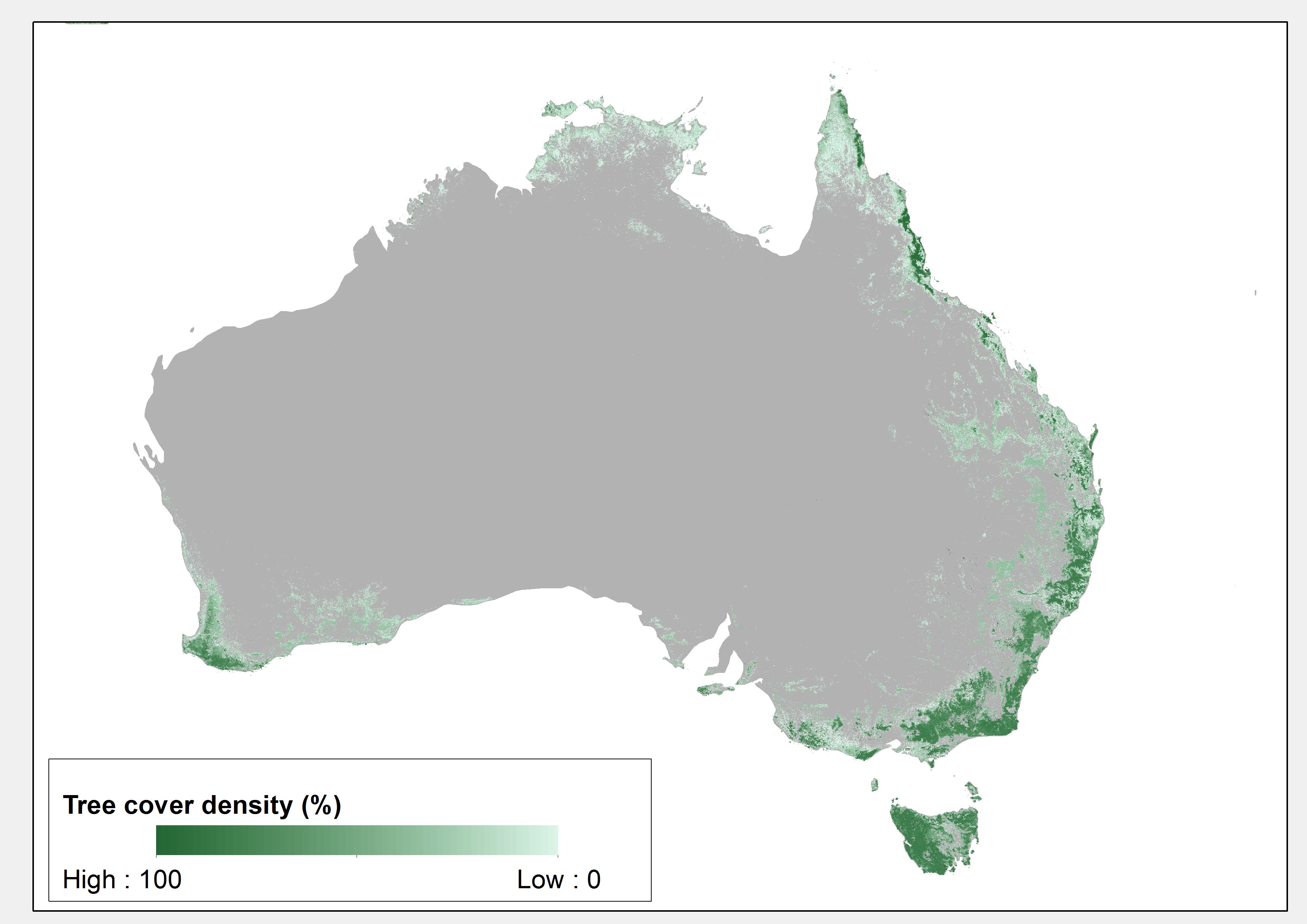
English: Australian forest cover |
| Date | |
| Source | Own work |
| Author | Mark Marathon |
Source: Title FAO FRA2010 Date 2001-07-01 Date type Creation: Date identifies when the resource was brought into existence Edition First edition. Presentation form Digital map: Map represented in raster or vector form Abstract Along with the core information on state and changes in forests, FRA 2000 is reporting on various ecological aspects of forests. Forest resources information will be reported by ecological zone, which will contribute to understanding the implications of forest change on (ecosystem) biological diversity and carbon-cycling processes. The 2000 global ecological zone map has been developed, building upon the FRA 1990 experience for the tropics and extending the coverage to include the temperate and boreal forests. A globally consistent classification has been adopted, based on the Koppen-Trewartha climate system in combination with natural vegetation characteristics. A total of 19 global ecological zones have been defined and mapped, ranging from the evergreen tropical rainforest zone to the boreal tundra woodland zone. A main principle of delineating the global ecological zones involved the aggregation or matching of available regional ecological or potential vegetation maps into the global framework. Purpose Main uses of the map include: a) reporting purposes, to provide baseline forest statistics by ecological zone; b) analysis and modelling purposes, i.e. assessment of forest-based biological diversity, both at ecosystem and species level, and biomass modelling. Status On going: Data is continually being updated Descriptive keywords FORESTS . Descriptive keywords Ecology , FRA 2000 . Descriptive keywords World (place). Spatial representation type Grid: Grid data is used to represent geographic data Language English Character set UTF8: 8-bit variable size UCS Transfer Format, based on ISO/IEC 10646 Topic category code Imagery base maps earth cover
The spatial data identified as FAO Core Datasets share the following characteristics: • Coarse resolution data, between 30 arcsec and 10 arcmin for the rasters, and between 1:1 million and 1:10 million scale for the vectors. • Related to a global, continental or regional level. Country data are not considered at this stage. • FAO as the main producer of the data or with publication rights as partner of a group that released the data. • Data release and access is unrestricted (public domain). • Primary (observed, mapped) and modeled data qualify.
Licensing[edit]
- You are free:
- to share – to copy, distribute and transmit the work
- to remix – to adapt the work
- Under the following conditions:
- attribution – You must give appropriate credit, provide a link to the license, and indicate if changes were made. You may do so in any reasonable manner, but not in any way that suggests the licensor endorses you or your use.
- share alike – If you remix, transform, or build upon the material, you must distribute your contributions under the same or compatible license as the original.
File history
Click on a date/time to view the file as it appeared at that time.
| Date/Time | Thumbnail | Dimensions | User | Comment | |
|---|---|---|---|---|---|
| current | 02:14, 19 July 2017 |  | 3,508 × 2,480 (8.3 MB) | Mark Marathon (talk | contribs) | User created page with UploadWizard |
You cannot overwrite this file.
File usage on Commons
There are no pages that use this file.