File:Arrowwood National Wildlife Refuge on sectional aeronautical charts.png
Jump to navigation
Jump to search

Size of this preview: 474 × 599 pixels. Other resolutions: 190 × 240 pixels | 380 × 480 pixels | 796 × 1,006 pixels.
Original file (796 × 1,006 pixels, file size: 1.09 MB, MIME type: image/png)
Captions
Captions
Add a one-line explanation of what this file represents
Summary[edit]
| Description |
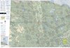
English: The Arrowwood National Wildlife Refuge, shown on the sectional aeronautical chart. Pilots are expected to avoid overflying at this altitude below 2000 ft AGL. |
| Date | |
| Source | |
| Author | Federal Aviation Administration, Mission Support Services, Aeronautical Information Services (AJV-5) |
Licensing[edit]
This image or file is a work of a Federal Aviation Administration employee, taken or made as part of that person's official duties. As a work of the U.S. federal government, the image is in the public domain in the United States.
|
 |
File history
Click on a date/time to view the file as it appeared at that time.
| Date/Time | Thumbnail | Dimensions | User | Comment | |
|---|---|---|---|---|---|
| current | 20:05, 18 February 2024 | | 796 × 1,006 (1.09 MB) | 痛 (talk | contribs) | Uploaded a work by Federal Aviation Administration, Mission Support Services, Aeronautical Information Services (AJV-5) from [https://www.faa.gov/air_traffic/flight_info/aeronav/digital_products/vfr/ VFR Raster Charts], by FAA with UploadWizard |
You cannot overwrite this file.
File usage on Commons
The following page uses this file:
File usage on other wikis
The following other wikis use this file:
- Usage on en.wikipedia.org