File:ArgentinayChile1929.TouringclubitalianoMilano.djvu

Original file (3,949 × 6,655 pixels, file size: 4.39 MB, MIME type: image/vnd.djvu)
Captions
Captions
| Description |
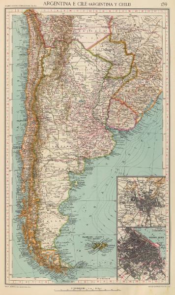
English: Map of Argentina and Chile on a scale of 1:10,000,000 published in 1929 by the Touring Club Italiano de Milano and showing Picton and Nueva Islands under Argentine sovereignty.
Español: Mapa de Argentina y Chile con una escala de 1:10.000.000 publicado en 1929 por el Touring Club Italiano de Milán y mostrando a las Islas Picton y Nueva bajo soberanía argentina. |
||||
| Date | |||||
| Source | http://www.davidrumsey.com/luna/servlet/detail/RUMSEY~8~1~31927~1151235:Argentina-e-Cile,-Argentina-y-Chile | ||||
| Author | Ufficio cartografico del Touring Club Italiano | ||||
| Permission (Reusing this file) |
|
||||
| Other versions | |||||

File history
Click on a date/time to view the file as it appeared at that time.
| Date/Time | Thumbnail | Dimensions | User | Comment | |
|---|---|---|---|---|---|
| current | 22:10, 15 September 2008 |  | 3,949 × 6,655 (4.39 MB) | Keysanger (talk | contribs) | {{Information |Description={{en|1=Map of Chile and Argentina, scale 1:10.000.000 published in 1929 by the Touring Club Italiano de Milano and showing Picton and Nueva Islands under Argentine souvereignty}} |Source=http://www.davidrumsey.com/luna/servlet/d |
You cannot overwrite this file.
File usage on Commons
The following 2 pages use this file:
File usage on other wikis
The following other wikis use this file:
- Usage on azb.wikipedia.org