File:Aralsee.gif
Jump to navigation
Jump to search
Size of this preview: 409 × 599 pixels. Other resolutions: 164 × 240 pixels | 558 × 817 pixels.
Original file (558 × 817 pixels, file size: 94 KB, MIME type: image/gif, looped, 8 frames, 27 s)
Captions
Captions
Add a one-line explanation of what this file represents
|
Summary[edit]
| Description |
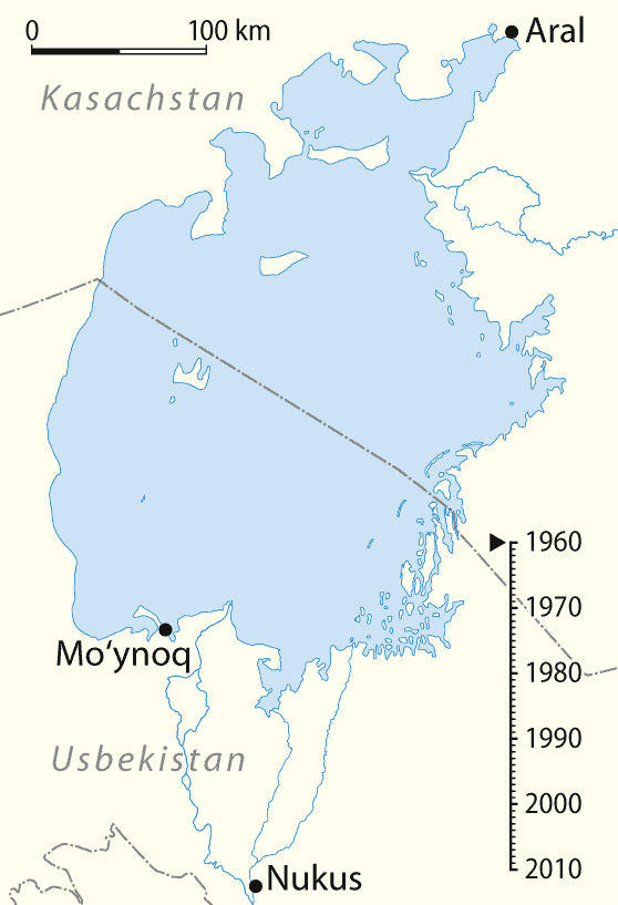
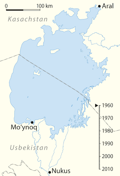
Deutsch: Animierte Karte des Austrocknens des Aralsees, deutsche Version
English: Animated map of the shrinking of the Aral Sea, German Version
Español: Mapa animado del cambio del Mar de Aral, versión alemana |
| Date | 04-03-2008 |
| Source |
own work, using
|
| Author | NordNordWest |
| Other versions |
|

|
This map has been made or improved in the German Kartenwerkstatt (Map Lab). You can propose maps to improve as well.
|
Licensing[edit]
I, the copyright holder of this work, hereby publish it under the following licenses:

|
Permission is granted to copy, distribute and/or modify this document under the terms of the GNU Free Documentation License, Version 1.2 or any later version published by the Free Software Foundation; with no Invariant Sections, no Front-Cover Texts, and no Back-Cover Texts. A copy of the license is included in the section entitled GNU Free Documentation License. |
This file is licensed under the Creative Commons Attribution-Share Alike 3.0 Unported license.
- You are free:
- to share – to copy, distribute and transmit the work
- to remix – to adapt the work
- Under the following conditions:
- attribution – You must give appropriate credit, provide a link to the license, and indicate if changes were made. You may do so in any reasonable manner, but not in any way that suggests the licensor endorses you or your use.
- share alike – If you remix, transform, or build upon the material, you must distribute your contributions under the same or compatible license as the original.
You may select the license of your choice.
File history
Click on a date/time to view the file as it appeared at that time.
| Date/Time | Thumbnail | Dimensions | User | Comment | |
|---|---|---|---|---|---|
| current | 17:54, 13 May 2010 | | 558 × 817 (94 KB) | NordNordWest (talk | contribs) | optimized |
| 20:06, 10 May 2010 |  | 558 × 817 (90 KB) | NordNordWest (talk | contribs) | update | |
| 08:50, 21 May 2008 |  | 560 × 819 (275 KB) | San Jose (talk | contribs) | optimiert | |
| 10:43, 4 April 2008 |  | 560 × 819 (1.06 MB) | NordNordWest (talk | contribs) | ||
| 10:01, 4 March 2008 |  | 559 × 819 (146 KB) | NordNordWest (talk | contribs) | {{Information |Description={{de}} Animierte Karte des Austrocknens des Aralsees {{en}} Animated map of the shrinking of the Aral Sea |Source=own work, using * NASA images * United States National Imagery and Mapping Agenc |
You cannot overwrite this file.
File usage on Commons
The following 3 pages use this file:
File usage on other wikis
The following other wikis use this file:
- Usage on az.wikipedia.org
- Usage on ba.wikipedia.org
- Usage on be.wikipedia.org
- Usage on br.wikipedia.org
- Usage on ca.wikipedia.org
- Usage on de.wikipedia.org
- Usage on de.wikivoyage.org
- Usage on en.wikipedia.org
- Usage on fr.wikipedia.org
- Usage on hr.wikipedia.org
- Usage on hsb.wikipedia.org
- Usage on hy.wikipedia.org
- Usage on id.wikipedia.org
- Usage on is.wikipedia.org
- Usage on ka.wikipedia.org
- Usage on kk.wikipedia.org
- Usage on ko.wikipedia.org
- Usage on la.wikipedia.org
- Usage on lt.wikipedia.org
- Usage on oc.wikipedia.org
- Usage on ro.wikipedia.org
- Usage on ru.wikipedia.org
- Usage on sc.wikipedia.org
- Usage on sh.wikipedia.org
- Usage on sl.wikipedia.org
- Usage on tr.wikipedia.org
View more global usage of this file.