File:Aral Sea.gif
Jump to navigation
Jump to search
Size of this preview: 410 × 600 pixels. Other resolutions: 164 × 240 pixels | 560 × 819 pixels.
Original file (560 × 819 pixels, file size: 465 KB, MIME type: image/gif, looped, 8 frames, 15 s)
Captions
Captions
Add a one-line explanation of what this file represents
Summary[edit]
| Description |
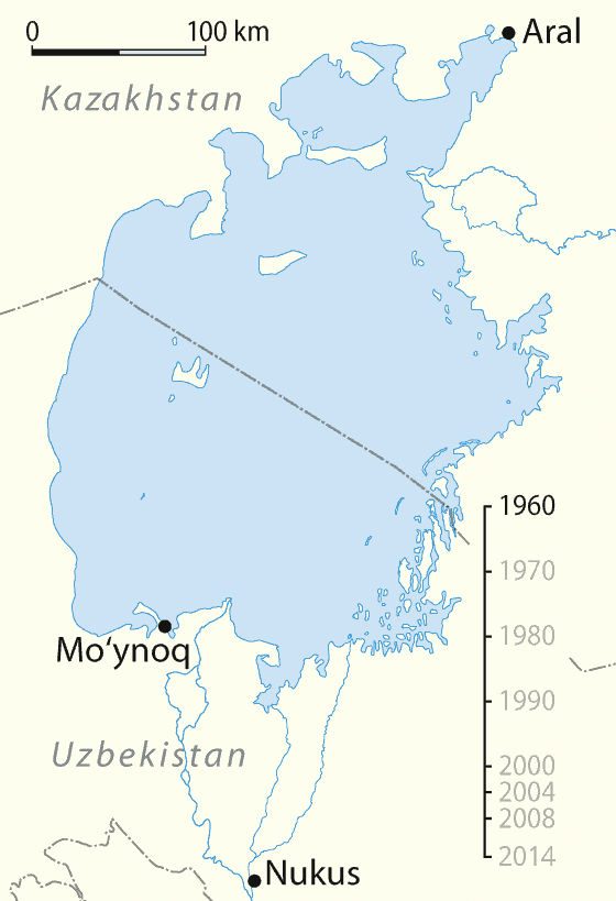
Deutsch: Animierte Karte des Austrocknens des Aralsees, englische Version
English: Animated map of the shrinking of the Aral Sea, English Version
Español: Mapa animado del cambio del Mar de Aral, versión inglés
Français : Animation de l'assèchement de la Mer d'Aral entre 1960 et 2014. version anglaise
Русский: Снижение уровня Аральского моря
Čeština: Vysychání (zmenšování plochy) Aralského jezera v období let 1960 - 2014.
العربية: البيان الزمني لتقلص بحر آرال.
Эрзянь: Аралонь иневедень ёмавтомась-вишкалговтомась шкасо. |
| Date | 01-05-2008 |
| Source |
Own work using:
|
| Author | NordNordWest |
| Other versions |
|
Assessment[edit]
| This file was selected as the media of the day for 5 January 2021. It was captioned as follows:
English: Aral Sea, timeline of shrinking.
Other languages
العربية: البيان الزمني لتقلص بحر آرال. Čeština: Vysychání (zmenšování plochy) Aralského jezera v období let 1960 - 2014. English: Aral Sea, timeline of shrinking. Français : Animation de l'assèchement de la mer d'Aral entre 1960 et 2014. Эрзянь: Аралонь иневедень ёмавтомась-вишкалговтомась шкасо. Русский: Снижение уровня Аральского моря
|

|
This map has been made or improved in the German Kartenwerkstatt (Map Lab). You can propose maps to improve as well.
|
Licensing[edit]
I, the copyright holder of this work, hereby publish it under the following licenses:

|
Permission is granted to copy, distribute and/or modify this document under the terms of the GNU Free Documentation License, Version 1.2 or any later version published by the Free Software Foundation; with no Invariant Sections, no Front-Cover Texts, and no Back-Cover Texts. A copy of the license is included in the section entitled GNU Free Documentation License. |
This file is licensed under the Creative Commons Attribution-Share Alike 3.0 Unported license.
- You are free:
- to share – to copy, distribute and transmit the work
- to remix – to adapt the work
- Under the following conditions:
- attribution – You must give appropriate credit, provide a link to the license, and indicate if changes were made. You may do so in any reasonable manner, but not in any way that suggests the licensor endorses you or your use.
- share alike – If you remix, transform, or build upon the material, you must distribute your contributions under the same or compatible license as the original.
You may select the license of your choice.
File history
Click on a date/time to view the file as it appeared at that time.
| Date/Time | Thumbnail | Dimensions | User | Comment | |
|---|---|---|---|---|---|
| current | 14:55, 30 April 2020 | | 560 × 819 (465 KB) | Palosirkka (talk | contribs) | size optimized with the GIMP |
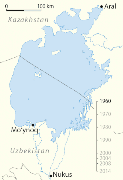
| 20:13, 12 January 2016 |  | 560 × 819 (534 KB) | Rwxrwxrwx (talk | contribs) | added 2014 frame | |
| 18:41, 7 January 2009 |  | 560 × 819 (479 KB) | Hk kng (talk | contribs) | Size optimization | |
| 15:36, 1 May 2008 |  | 560 × 819 (1.05 MB) | NordNordWest (talk | contribs) | {{Information |Description= {{de}} Animierte Karte des Austrocknens des Aralsees, englische Version {{en}} Animated map of the shrinking of the Aral Sea, English Version {{es}} Mapa animado del cambio del [[:es:Mar de Ara |
You cannot overwrite this file.
File usage on Commons
The following 12 pages use this file:
- User:Magog the Ogre/Multilingual legend/2020 April 21-30
- User talk:NordNordWest/Archive13
- Template:Motd/2021-01
- Template:Motd/2021-01-05
- Template:Motd/2021-01-05 (ar)
- Template:Motd/2021-01-05 (cs)
- Template:Motd/2021-01-05 (en)
- Template:Motd/2021-01-05 (fr)
- Template:Motd/2021-01-05 (myv)
- Template:Motd/2021-01-05 (ru)
- Template:Motd/2021-01-05 (uk)
- Template:Potd/2021-01
File usage on other wikis
The following other wikis use this file:
- Usage on af.wikipedia.org
- Usage on am.wikipedia.org
- Usage on ban.wikipedia.org
- Usage on bat-smg.wikipedia.org
- Usage on ba.wikipedia.org
- Баш бит
- Ҡатнашыусы:Регион102/Баш бит
- Ҡатнашыусы:Регион102/Баш бит/Ҡыҙыҡ мәғлүмәт
- Ҡалып:Беләһеңме
- Ҡалып:Ҡыҙыҡ мәғлүмәт
- Википедия:Ҡыҙыҡ мәғлүмәт
- Википедия:Ҡыҙыҡ мәғлүмәт/Тәҡдим
- Ҡатнашыусы:Регион102/Баш бит2
- Ҡатнашыусы:Регион102/Баш бит2/Ҡыҙыҡ мәғлүмәт
- Ҡатнашыусы:Регион102/Баш бит3
- Ҡатнашыусы:Регион102/Баш бит4
- Ҡатнашыусы:Регион102/Баш бит5
- Ҡатнашыусы:Регион102/Баш бит5.2
- Ҡатнашыусы:Регион102/Баш бит6
- Ҡатнашыусы:Регион102/Баш бит6.2
- Ҡатнашыусы:Регион102/Баш бит5.3
- Арал диңгеҙе
- Ҡатнашыусы:Рөстәм Нурыев/Баш бит
- Ҡатнашыусы:Рөстәм Нурыев/Баш бит 1
- Арал диңгеҙенең кимәле кәмеүе
- Ҡатнашыусы:ZUFAr/Баш бит
- Usage on be-tarask.wikipedia.org
- Usage on be.wikipedia.org
- Usage on bg.wikipedia.org
- Usage on bh.wikipedia.org
- Usage on bn.wikipedia.org
- Usage on bs.wikipedia.org
- Usage on bxr.wikipedia.org
- Usage on ca.wikipedia.org
- Usage on cdo.wikipedia.org
- Usage on ceb.wikipedia.org
- Usage on ckb.wikipedia.org
- Usage on cs.wikipedia.org
- Usage on cv.wikipedia.org
- Usage on cy.wikipedia.org
- Usage on da.wikipedia.org
- Usage on de.wikipedia.org
- Usage on dsb.wikipedia.org
- Usage on el.wikipedia.org
- Usage on en.wikipedia.org
View more global usage of this file.