File:Anglo American War 1812 Locations map-es.svg
Jump to navigation
Jump to search

Size of this PNG preview of this SVG file: 800 × 444 pixels. Other resolutions: 320 × 178 pixels | 640 × 356 pixels | 1,024 × 569 pixels | 1,280 × 711 pixels | 2,560 × 1,422 pixels | 1,494 × 830 pixels.
Original file (SVG file, nominally 1,494 × 830 pixels, file size: 127 KB)
Captions
Captions
Add a one-line explanation of what this file represents
Summary[edit]
| Description |
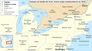
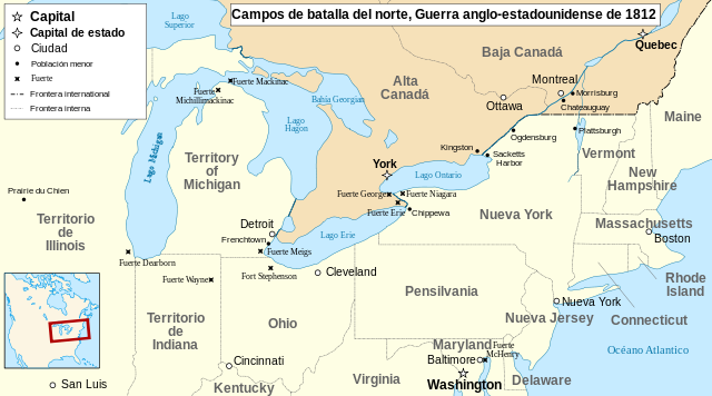
English: Main locations of the War of 1812 between the United States and the United Kingdom Français : Principaux théâtres d'opérations de la Guerre de 1812 entre les États-Unis et le Royaume-Uni. Español: Principales teatros de operaciones de la Guerra de 1812 entre los Estados Unidos y el Reino Unido. |
| Date | (UTC) |
| Source |
This file was derived from: Anglo American War 1812 Locations map-en.svg: |
| Author |
|
| This is a retouched picture, which means that it has been digitally altered from its original version. Modifications: translated into Spanish. The original can be viewed here: Anglo American War 1812 Locations map-en.svg:
|
Licensing[edit]
This file is licensed under the Creative Commons Attribution-Share Alike 3.0 Unported license.
- You are free:
- to share – to copy, distribute and transmit the work
- to remix – to adapt the work
- Under the following conditions:
- attribution – You must give appropriate credit, provide a link to the license, and indicate if changes were made. You may do so in any reasonable manner, but not in any way that suggests the licensor endorses you or your use.
- share alike – If you remix, transform, or build upon the material, you must distribute your contributions under the same or compatible license as the original.
Original upload log[edit]
This image is a derivative work of the following images:
- File:Anglo_American_War_1812_Locations_map-en.svg licensed with Cc-by-sa-3.0,2.5,2.0,1.0, GFDL
- 2011-07-25T18:03:38Z Amirki 1494x830 (130976 Bytes) minor color change
- 2011-01-22T21:05:33Z P. S. Burton 1494x830 (156557 Bytes) {{Information |Description={{en|1=Main locations of the [[:en:War of 1812|War of 1812]] between the United States and the United Kingdom}} {{fr|1=Principaux théâtres d'opérations de la [[:fr:Guerre de 1812|Guerre de 1812]]
Uploaded with derivativeFX
File history
Click on a date/time to view the file as it appeared at that time.
| Date/Time | Thumbnail | Dimensions | User | Comment | |
|---|---|---|---|---|---|
| current | 16:58, 18 October 2012 | | 1,494 × 830 (127 KB) | Rowanwindwhistler (talk | contribs) | == {{int:filedesc}} == {{Information |Description={{en|1=Main locations of the War of 1812 between the United States and the United Kingdom}} {{fr|1=Principaux théâtres d'opérations de la Guerre de 1812 ent... |
You cannot overwrite this file.
File usage on Commons
There are no pages that use this file.
File usage on other wikis
The following other wikis use this file:
- Usage on eo.wikipedia.org
- Usage on es.wikipedia.org