File:An accurate map of North America - drawn from the best modern maps and charts, and regulated by astron'l. observatns. - by Eman. Bowen, geog'r. to His Majesty, 1747. NYPL1258748.tiff
Jump to navigation
Jump to search

Size of this JPG preview of this TIF file: 800 × 497 pixels. Other resolutions: 320 × 199 pixels | 640 × 398 pixels | 1,024 × 637 pixels | 1,280 × 796 pixels | 2,560 × 1,591 pixels | 4,213 × 2,619 pixels.
Original file (4,213 × 2,619 pixels, file size: 31.57 MB, MIME type: image/tiff)
Captions
Captions
Add a one-line explanation of what this file represents
Summary[edit]
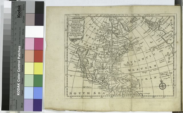
| Description | An accurate map of North America : drawn from the best modern maps and charts, and regulated by astron'l. observatns. / by Eman. Bowen, geog'r. to His Majesty, 1747. | |||||||||||||||||||||||
| Notes | In upper left corner: to face vol. II. Note 2.) Lawrence H. Slaughter Collection. Note 3.) Prime meridian: London. Note 4.) Relief shown pictorially. | |||||||||||||||||||||||
| Standard reference | Todd, 4a; ESTC, T006290. | |||||||||||||||||||||||
| Physical description | 1 map ; 15 x 20 cm. folded to 20 x 10 cm. | |||||||||||||||||||||||
| Catalog Call Number | Map Div. 97-6467 (Vol. 2, map facing t.p.) [In LHS 3033] | |||||||||||||||||||||||
| Date | ||||||||||||||||||||||||
| Source |
http://digitalgallery.nypl.org/nypldigital/dgkeysearchdetail.cfm?imageID=1258748
|
|||||||||||||||||||||||
| Author | Bowen, Emanuel, d. 1767 -- Geographer (not in Relator list)Burke, Edmund, 1729-1797 -- Author ;Burke, William, 1730-1798 -- Associated name ;Dodsley, James, 1724-1797 -- Publisher ;R. and J. Dodsley -- Publisher | |||||||||||||||||||||||
| Permission (Reusing this file) |
From The Lionel Pincus & Princess Firyal Map Division. Released on a CC0 license.[1] | |||||||||||||||||||||||
| Source Description | 2 v. ([8], 312 p., [1] folded leaf of plates; [2], 300, [20] p., [1] folded leaf of plates) : 2 maps ; 20 cm. | |||||||||||||||||||||||
| Digital ID | 1258748 | |||||||||||||||||||||||
| Location | Stephen A. Schwarzman Building / The Lionel Pincus and Princess Firyal Map Division | |||||||||||||||||||||||
| NYPL digital item published | 2-26-2005; updated 1-9-2012 | |||||||||||||||||||||||

Licensing[edit]
| This file is made available under the Creative Commons CC0 1.0 Universal Public Domain Dedication. | |
| The person who associated a work with this deed has dedicated the work to the public domain by waiving all of their rights to the work worldwide under copyright law, including all related and neighboring rights, to the extent allowed by law. You can copy, modify, distribute and perform the work, even for commercial purposes, all without asking permission.
|
The making of this file was supported by Wikimedia UK.
To see other files made with the support of Wikimedia UK, please see the category Supported by Wikimedia UK.
|
File history
Click on a date/time to view the file as it appeared at that time.
| Date/Time | Thumbnail | Dimensions | User | Comment | |
|---|---|---|---|---|---|
| current | 20:53, 5 April 2014 |  | 4,213 × 2,619 (31.57 MB) | Fæ (talk | contribs) | =={{int:filedesc}}== {{NYPL_map |source_description = 2 v. ([8], 312 p., [1] folded leaf of plates; [2], 300, [20] p., [1] folded leaf of plates) : 2 maps ; 20 cm. |standard_reference = Todd, 4a; ESTC, T006290. |record_id = 254128 |catalog_call_number... |
You cannot overwrite this file.
File usage on Commons
There are no pages that use this file.