File:Americans with Arab Ancestry by state.svg

Original file (SVG file, nominally 959 × 593 pixels, file size: 75 KB)
Captions
Captions
Summary[edit]
| Description |
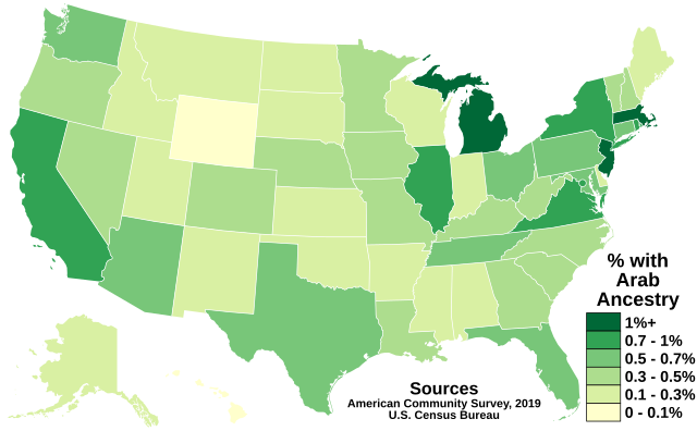
English: The map above shows the prevalence of Americans with Arab Ancestry in each state of the United States and in the District of Columbia. Data comes from the U.S. Census Bureau's American Community Survey 2019 (1-Year), from which data is easily accessible here.
In 2019, there were an estimated 2,097,642 Americans with Arab Ancestry in the United States, making up approximately 0.639% of the country's 328.2 million inhabitants. The five states with the most Americans with Arab Ancestry were California (314,014), Michigan (221,631), New York (184,342), Texas (167,476), and Florida (123,160). The five states with the highest concentration of Americans with Arab Ancestry were Michigan (2.22%), New Jersey (1.21%), Massachusetts (1.03%), New York (0.95%), and Virginia (0.93%). This file may be updated upon the publishing of newer data. Legend 1%+
0.7 - 1%
0.5 - 0.7%
0.3 - 0.5%
0.1 - 0.3%
0 - 0.1% |
| Date | |
| Source | Own work |
| Author | Abbasi786786 |
Licensing[edit]
- You are free:
- to share – to copy, distribute and transmit the work
- to remix – to adapt the work
- Under the following conditions:
- attribution – You must give appropriate credit, provide a link to the license, and indicate if changes were made. You may do so in any reasonable manner, but not in any way that suggests the licensor endorses you or your use.
- share alike – If you remix, transform, or build upon the material, you must distribute your contributions under the same or compatible license as the original.
File history
Click on a date/time to view the file as it appeared at that time.
| Date/Time | Thumbnail | Dimensions | User | Comment | |
|---|---|---|---|---|---|
| current | 13:45, 4 March 2021 | | 959 × 593 (75 KB) | Abbasi786786 (talk | contribs) | Reverted to version as of 17:23, 3 March 2021 (UTC) Back to transparent background |
| 13:38, 4 March 2021 |  | 959 × 593 (76 KB) | Abbasi786786 (talk | contribs) | Reverted to version as of 22:45, 2 March 2021 (UTC) Getting PNG | |
| 17:23, 3 March 2021 |  | 959 × 593 (75 KB) | Abbasi786786 (talk | contribs) | Transparent Background | |
| 22:45, 2 March 2021 |  | 959 × 593 (76 KB) | Abbasi786786 (talk | contribs) | Uploaded own work with UploadWizard |
You cannot overwrite this file.
File usage on Commons
There are no pages that use this file.
File usage on other wikis
The following other wikis use this file:
- Usage on ar.wikipedia.org
- Usage on de.wikiversity.org
- Usage on en.wikipedia.org
- Usage on simple.wikipedia.org