File:Alert, Canada ESA375402.tiff

Original file (4,620 × 3,591 pixels, file size: 47.5 MB, MIME type: image/tiff)
Captions
Captions
Summary[edit]
| DescriptionAlert, Canada ESA375402.tiff |
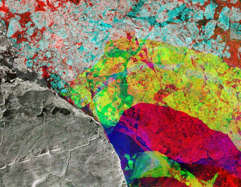
English: This Sentinel-1 radar composite image takes us to the northeastern tip of Ellesmere Island (lower-left), where the Nares Strait opens up into the Lincoln Sea in the Canadian Arctic.
The image was created by combining three radar scans from Copernicus Sentinel-1 captured in December, January and February. Each image has been assigned a colour – red, green and blue – and create this colourful composite when combined. Colours show changes between acquisitions, such as the movement of ice in the Lincoln Sea, while the static landmass is grey. The obvious distinction between the red and yellow depicts how the ice cover has changed over the three months. The maximum extent of Arctic sea ice hit a record low this winter. Scientists attribute the reduced ice cover to a very warm autumn and winter, exacerbated by a number of extreme winter ‘heat waves’ over the Arctic Ocean. In the centre-left on the land, we can see a straight, dark link with a circle at its left end. This is the runway for Alert – the northernmost known settlement in the world. Inhabited mainly by military and scientific personnel on rotation, Alert is about 800 km from the North Pole. A team of researchers on the CryoVex/Karen campaign was recently in Alert validating sea-ice thickness measurements from the CryoSat satellite and testing future satellite mission concepts. Taking off from Alert, the team flew two aircraft equipped with instruments that measure sea-ice thickness at the same time the satellite flew some 700 km overhead. The measurements from the airborne campaign will be compared to the satellite measurements in order to confirm the satellite’s accuracy. A team will also make ground measurements of snow and ice along a CryoSat ground track in April. Ground campaigns like this provide a wealth of data that help scientists better understand how the Arctic is changing and, ultimately, how climate is changing. This image is featured on the Earth from Space video programme. |
| Date | |
| Source | http://www.esa.int/spaceinimages/Images/2017/03/Alert_Canada |
| Author | European Space Agency |
| Permission (Reusing this file) |
contains modified Copernicus Sentinel data (2016-17), processed by ESA,CC BY-SA 3.0 IGO |
| Other versions |
|
| Title InfoField | Alert, Canada |
| Set InfoField | Earth observation image of the week |
| System InfoField | Copernicus |
| Mission InfoField | Sentinel-1 |
| Location InfoField | Canada |
| Activity InfoField | Observing the Earth |
| Keywords InfoField | Ice |
Licensing[edit]
This media was created by the European Space Agency (ESA).
Where expressly so stated, images or videos are covered by the Creative Commons Attribution-ShareAlike 3.0 IGO (CC BY-SA 3.0 IGO) licence, ESA being an Intergovernmental Organisation (IGO), as defined by the CC BY-SA 3.0 IGO licence. The user is allowed under the terms and conditions of the CC BY-SA 3.0 IGO license to Reproduce, Distribute and Publicly Perform the ESA images and videos released under CC BY-SA 3.0 IGO licence and the Adaptations thereof, without further explicit permission being necessary, for as long as the user complies with the conditions and restrictions set forth in the CC BY-SA 3.0 IGO licence, these including that:
See the ESA Creative Commons copyright notice for complete information, and this article for additional details.
|
 | |
This file is licensed under the Creative Commons Attribution-ShareAlike 3.0 IGO license. Attribution: ESA/Copernicus, CC BY-SA IGO 3.0
| ||
File history
Click on a date/time to view the file as it appeared at that time.
| Date/Time | Thumbnail | Dimensions | User | Comment | |
|---|---|---|---|---|---|
| current | 09:53, 6 May 2017 |  | 4,620 × 3,591 (47.5 MB) | Fæ (talk | contribs) | == {{int:filedesc}} == {{information | description = {{en|1=This Sentinel-1 radar composite image takes us to the northeastern tip of Ellesmere Island (lower-left), where the Nares Strait opens up into the Lincoln Sea in the Canadian Arctic. The image... |
You cannot overwrite this file.
File usage on Commons
The following 2 pages use this file:
Metadata
This file contains additional information such as Exif metadata which may have been added by the digital camera, scanner, or software program used to create or digitize it. If the file has been modified from its original state, some details such as the timestamp may not fully reflect those of the original file. The timestamp is only as accurate as the clock in the camera, and it may be completely wrong.
| Width | 4,620 px |
|---|---|
| Height | 3,591 px |
| Bits per component |
|
| Compression scheme | Uncompressed |
| Pixel composition | RGB |
| Image data location | 35,746 |
| Orientation | Normal |
| Number of components | 3 |
| Number of rows per strip | 3,591 |
| Bytes per compressed strip | 49,771,260 |
| Horizontal resolution | 72 dpi |
| Vertical resolution | 72 dpi |
| Data arrangement | chunky format |
| Software used | Adobe Photoshop CC 2017 (Windows) |
| File change date and time | 12:59, 23 March 2017 |
| Color space | sRGB |


