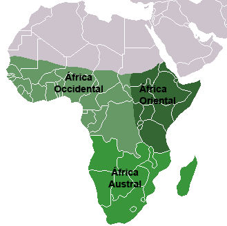
File:Africa Subsahariana.png
Africa_Subsahariana.png (329 × 328 pixels, file size: 13 KB, MIME type: image/png)
Captions
Captions
| DescriptionAfrica Subsahariana.png |
Español: Grandes regiones del África subsahariana, texto en español |
||
| Date | |||
| Source | From Image:BlankMap-World.png | ||
| Author | José-Manuel Benito | ||
| Permission (Reusing this file) |
|
File history
Click on a date/time to view the file as it appeared at that time.
| Date/Time | Thumbnail | Dimensions | User | Comment | |
|---|---|---|---|---|---|
| current | 20:19, 9 July 2011 |  | 329 × 328 (13 KB) | Maphobbyist (talk | contribs) | South Sudan has become independent on July 9, 2011. Sudan and South Sudan are shown with the new international border between them. |
| 21:59, 8 May 2006 |  | 329 × 328 (7 KB) | Locutus Borg (talk | contribs) | == Sumario == From Image:BlankMap-World.png <!--Categories--> Category:Maps of Africa Category:World maps indicating regions == Licensing == {{GPL}} |
You cannot overwrite this file.
File usage on Commons
There are no pages that use this file.
File usage on other wikis
The following other wikis use this file:
- Usage on ca.wikipedia.org
- Usage on es.wikipedia.org
- Usage on frp.wikipedia.org
- Usage on gl.wikipedia.org

