File:Afar colonisation map de.svg
Jump to navigation
Jump to search

Size of this PNG preview of this SVG file: 423 × 599 pixels. Other resolutions: 169 × 240 pixels | 339 × 480 pixels | 542 × 768 pixels | 723 × 1,024 pixels | 1,445 × 2,048 pixels | 1,063 × 1,506 pixels.
Original file (SVG file, nominally 1,063 × 1,506 pixels, file size: 720 KB)
Captions
Captions
Add a one-line explanation of what this file represents
Summary[edit]
| Description |
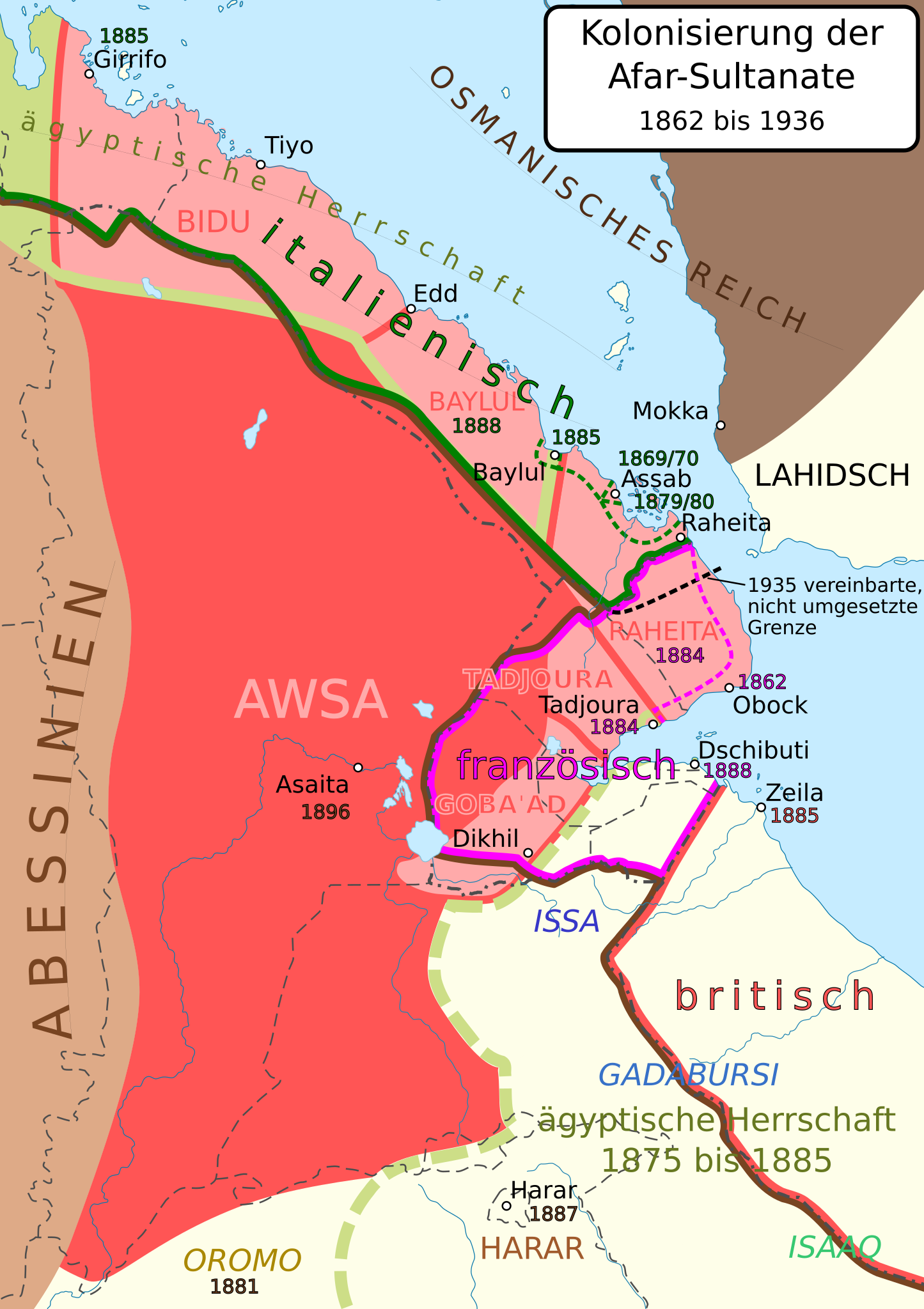
English: map of the colonisation of the aar sultanates between 1862 and 1936
Deutsch: Karte der Kolonisierung der Afar-Sultanate zwischen 1862 und 1936. Quellen:
|
| Date | |
| Source | Own work, used for composite background map: File:Djibouti adm location map.svg, File:Eritrea adm location map.svg, File:Afar in Ethiopia.svg |
| Author | Don-kun, used maps by NordNordWest, TUBS |
.jpg)
Licensing[edit]
I, the copyright holder of this work, hereby publish it under the following license:
This file is licensed under the Creative Commons Attribution 3.0 Unported license.
- You are free:
- to share – to copy, distribute and transmit the work
- to remix – to adapt the work
- Under the following conditions:
- attribution – You must give appropriate credit, provide a link to the license, and indicate if changes were made. You may do so in any reasonable manner, but not in any way that suggests the licensor endorses you or your use.
File history
Click on a date/time to view the file as it appeared at that time.
| Date/Time | Thumbnail | Dimensions | User | Comment | |
|---|---|---|---|---|---|
| current | 19:46, 20 May 2020 | | 1,063 × 1,506 (720 KB) | Don-kun (talk | contribs) | fix Obock |
| 17:27, 17 May 2020 |  | 1,063 × 1,506 (720 KB) | Don-kun (talk | contribs) | {{Information |description ={{en|1=map of the colonisation of the aar sultanates between 1862 and 1936}} {{de|1=Karte der Kolonisierung der Afar-Sultanate zwischen 1862 und 1936. Quellen: * Sulanate: La Côte française des Somalis, La Documentation Française, 1949 ([https://www.facebook.com/326847264617369/photos/a.335692107066218/335692760399486/?type=3&theater Karte]) * Kolonialgrenzen: File:Africa 1909, Edward Hertslet (Map of Africa by treaty, 3rd edition).jpg; Simon Imbert-Vier. Fr... |
You cannot overwrite this file.
File usage on Commons
There are no pages that use this file.
File usage on other wikis
The following other wikis use this file:
- Usage on de.wikipedia.org
- Usage on pt.wikipedia.org