File:Administrative boundaries of the borough of Solln in Munich.png
Jump to navigation
Jump to search
Size of this preview: 637 × 600 pixels. Other resolutions: 255 × 240 pixels | 510 × 480 pixels | 816 × 768 pixels | 1,087 × 1,024 pixels | 1,406 × 1,324 pixels.
Original file (1,406 × 1,324 pixels, file size: 553 KB, MIME type: image/png)
Captions
Captions
Add a one-line explanation of what this file represents
| Description |
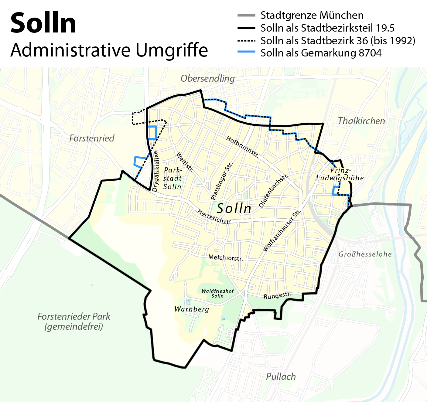
Deutsch: Administrative Umgriffe des Münchener Stadtteils Solln
English: Administrative boundaries of the borough of Solln in Munich |
| Date | see file history |
| Source | Own work, using OpenStreetMap data for the background |
| Author | Maximilian Dörrbecker (Chumwa) |
| Permission (Reusing this file) |
All OpenStreetMap data and maps are Creative Commons "CC-BY-SA 2.0" licensed This file is licensed under the Creative Commons Attribution-Share Alike 2.0 Generic license.
|
| Other versions |
Region München:
Stadt München:
|


.png)


.png)
.png)


File history
Click on a date/time to view the file as it appeared at that time.
| Date/Time | Thumbnail | Dimensions | User | Comment | |
|---|---|---|---|---|---|
| current | 12:31, 10 August 2012 | | 1,406 × 1,324 (553 KB) | Chumwa (talk | contribs) | anderer Ansatz |
| 21:40, 8 August 2012 |  | 1,075 × 957 (270 KB) | Chumwa (talk | contribs) | {{Information |Description= *{{ de }} Kartenserie der Münchner Stadtbezirke *{{ en }} Boroughs of Munich map series |Source={{own}}, using OpenStreetMap data for the background |Date=see file history |Author=[[:de:User:Chumwa|Maximilian Dörrbecke... |
You cannot overwrite this file.
File usage on Commons
The following 37 pages use this file:
- User:Chumwa/Gallery
- User:Chumwa/OtherVersions - Karten München
- File:Administrative boundaries of the borough of Solln in Munich.png
- File:Basiskarte Kiel.png
- File:Karte Flaucher München.png
- File:Karte München - WirtshausWiesn 2020.png
- File:Karte München Basiskarte.jpg
- File:Karte München Basiskarte.png
- File:Karte München Landnutzung.png
- File:Karte München Schwarzplan.png
- File:Karte München ÖPNV.png
- File:Karte München Übersichtsplan.png
- File:Karte Streetlife München.png
- File:Karte Viktualienmarkt München.png
- File:Karte der Burgfrieden von München.png
- File:Karte der Denkmalschutzensembles in München.jpg
- File:Karte der Gemarkungen in München.png
- File:Karte der Gemarkungen und Stadtbezirke in München.png
- File:Karte der Ortsbezeichnungen in München.png
- File:Karte der Parkstadt Bogenhausen in München.png
- File:Karte der Stadtbezirke in München.png
- File:Karte der Stadtbezirke in München in der bis 1992 gültigen Gliederung.png
- File:Karte der Stadtbezirksteile in München.png
- File:München - Basiskarte farbig.pdf
- File:München - Basiskarte farbig.png
- File:München - Basiskarte farbig - mit Nachbargemeinden.jpg
- File:München - Basiskarte farbig - mit Nachbargemeinden.png
- File:München - Basiskarte grau.pdf
- File:München - Basiskarte grau.png
- File:München - Stadtbezirk 19 (Karte V2) - Thalkirchen - Obersendling - Forstenried - Fürstenried - Solln.png (file redirect)
- File:München - Stadtbezirke (Karte).png
- File:Positionskarte München.png
- File:Stadterweiterungen München.png
- File:Westpark München (Karte).png
- File:Westpark München zur IGA 1983 (Karte).png
- Category:Maps of Solln
- Category:Solln
_-_Thalkirchen_-_Obersendling_-_Forstenried_-_F%C3%BCrstenried_-_Solln.png&redirect=no)
File usage on other wikis
The following other wikis use this file:
- Usage on de.wikipedia.org
- Usage on fr.wikipedia.org
- Usage on www.wikidata.org