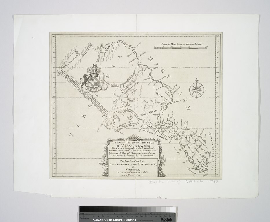
File:A survey of the Northern Neck of Virginia - being the lands belonging to the Rt. Honourable Thomas Lord Fairfax Baron Cameron, bounded by & within the Bay of Chesapoyocke and between the rivers NYPL434003.tiff
Jump to navigation
Jump to search

Size of this JPG preview of this TIF file: 728 × 599 pixels. Other resolutions: 292 × 240 pixels | 583 × 480 pixels | 933 × 768 pixels | 1,244 × 1,024 pixels | 2,488 × 2,048 pixels | 5,899 × 4,856 pixels.
Original file (5,899 × 4,856 pixels, file size: 81.96 MB, MIME type: image/tiff)
Captions
Captions
Add a one-line explanation of what this file represents
Summary[edit]
| Description | A survey of the Northern Neck of Virginia : being the lands belonging to the Rt. Honourable Thomas Lord Fairfax Baron Cameron, bounded by & within the Bay of Chesapoyocke and between the rivers Rappahannock and Potowmack: With the courses of the rivers Rappahannock and Potowmack, in Virginia, as surveyed according to order in the years 1736 & 1737. | |||||||||||||||||||||||
| Notes | "A scale of miles 69 1/2 in one degree of latitude." Note 2.) Author attribution by LC. Note 3.) Emmet Collection ; 7748. Note 4.) National Endowment for the Humanities Grant for Access to Early Maps of the Middle Atlantic Seaboard. Note 5.) Relief shown pictorially. | |||||||||||||||||||||||
| Standard reference | Virginia in maps, 76; EM7748; Phillips. Maps of America, p. 981 | |||||||||||||||||||||||
| Physical description | 1 map ; 30 x 34 cm. | |||||||||||||||||||||||
| Catalog Call Number | Map Div. 01-5078 [Filed with Virginia, 1737] | |||||||||||||||||||||||
| Date | circa 1747 | |||||||||||||||||||||||
| Source |
http://digitalgallery.nypl.org/nypldigital/dgkeysearchdetail.cfm?imageID=434003
|
|||||||||||||||||||||||
| Author | Warner, John, fl. 1727-1741 -- Surveyor | |||||||||||||||||||||||
| Permission (Reusing this file) |
From The Lionel Pincus & Princess Firyal Map Division. Released on a CC0 license.[1] | |||||||||||||||||||||||
| Digital ID | 434003 | |||||||||||||||||||||||
| Location | Stephen A. Schwarzman Building / The Lionel Pincus and Princess Firyal Map Division | |||||||||||||||||||||||
| NYPL digital item published | 2-3-2004; updated 3-25-2011 | |||||||||||||||||||||||

Licensing[edit]
| This file is made available under the Creative Commons CC0 1.0 Universal Public Domain Dedication. | |
| The person who associated a work with this deed has dedicated the work to the public domain by waiving all of their rights to the work worldwide under copyright law, including all related and neighboring rights, to the extent allowed by law. You can copy, modify, distribute and perform the work, even for commercial purposes, all without asking permission.
|
The making of this file was supported by Wikimedia UK.
To see other files made with the support of Wikimedia UK, please see the category Supported by Wikimedia UK.
|
File history
Click on a date/time to view the file as it appeared at that time.
| Date/Time | Thumbnail | Dimensions | User | Comment | |
|---|---|---|---|---|---|
| current | 04:58, 11 December 2017 |  | 5,899 × 4,856 (81.96 MB) | Finavon (talk | contribs) | rotated |
| 04:24, 10 April 2014 |  | 4,856 × 5,899 (81.96 MB) | Fæ (talk | contribs) | =={{int:filedesc}}== {{NYPL_map |digital_id = 434003 |standard_reference = Virginia in maps, 76; EM7748; Phillips. Maps of America, p. 981 |record_id = 252856 |catalog_call_number = Map Div. 01-5078 [Filed with Virginia, 1737] |creator = Warner, John,... |
You cannot overwrite this file.
File usage on Commons
The following page uses this file: