File:A map of ye English Empire in ye continent of America - viz Virginia, Maryland, Carolina, New York, New Iarsey, New England, Pennsilvania - W. Binneman sculpsit. NYPL434083.tiff
Jump to navigation
Jump to search

Size of this JPG preview of this TIF file: 692 × 599 pixels. Other resolutions: 277 × 240 pixels | 554 × 480 pixels | 887 × 768 pixels | 1,182 × 1,024 pixels | 2,364 × 2,048 pixels | 5,754 × 4,984 pixels.
Original file (5,754 × 4,984 pixels, file size: 82.06 MB, MIME type: image/tiff)
Captions
Captions
Add a one-line explanation of what this file represents
Summary[edit]
| Description | A map of ye English Empire in ye continent of America : viz Virginia, Maryland, Carolina, New York, New Iarsey, New England, Pennsilvania / W. Binneman sculpsit. | |||||||||||||||||||||||
| Notes | According to Stevens & Tree, author's name has been erased to make room for the insertion of "Pennsilvania". Note 2.) Covers North America from the Gulf of Saint Lawrence to the Great Lakes and South to Chesapeake Bay. Note 3.) Inset covers Chesapeake Bay to St. Augustine. Note 4.) Relief shown pictorially. Note 5.) National Endowment for the Humanities Grant for Access to Early Maps of the Middle Atlantic Seaboard. | |||||||||||||||||||||||
| Standard reference | Cumming, W.P. Southeast in early maps, 103; Stevens & Tree. Comparative cartography, 19b | |||||||||||||||||||||||
| Physical description | 1 map ; 49 x 58 cm. | |||||||||||||||||||||||
| Catalog Call Number | Map Div. 01-5359 [Filed with North America, Part of, [1700?], as originally cataloged in NYPL Dictionary Catalog of the Map Division] | |||||||||||||||||||||||
| Date | circa 1685 | |||||||||||||||||||||||
| Source |
http://digitalgallery.nypl.org/nypldigital/dgkeysearchdetail.cfm?imageID=434083
|
|||||||||||||||||||||||
| Author |
Daniel, R. (Richard) -- Cartographer
|
|||||||||||||||||||||||
| Permission (Reusing this file) |
From The Lionel Pincus & Princess Firyal Map Division. Released on a CC0 license.[1] | |||||||||||||||||||||||
| Digital ID | 434083 | |||||||||||||||||||||||
| Location | Stephen A. Schwarzman Building / The Lionel Pincus and Princess Firyal Map Division | |||||||||||||||||||||||
| NYPL digital item published | 2-3-2004; updated 3-25-2011 | |||||||||||||||||||||||

Licensing[edit]
| This file is made available under the Creative Commons CC0 1.0 Universal Public Domain Dedication. | |
| The person who associated a work with this deed has dedicated the work to the public domain by waiving all of their rights to the work worldwide under copyright law, including all related and neighboring rights, to the extent allowed by law. You can copy, modify, distribute and perform the work, even for commercial purposes, all without asking permission.
|
The making of this file was supported by Wikimedia UK.
To see other files made with the support of Wikimedia UK, please see the category Supported by Wikimedia UK.
|
File history
Click on a date/time to view the file as it appeared at that time.
| Date/Time | Thumbnail | Dimensions | User | Comment | |
|---|---|---|---|---|---|
| current | 07:53, 26 October 2023 |  | 5,754 × 4,984 (82.06 MB) | Sebastian Wallroth (talk | contribs) | Rotated 90° using CropTool with lossless mode. |
| 16:09, 4 April 2014 | 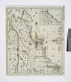 | 4,984 × 5,755 (82.07 MB) | Fæ (talk | contribs) | =={{int:filedesc}}== {{NYPL_map |digital_id = 434083 |standard_reference = Cumming, W.P. Southeast in early maps, 103; Stevens & Tree. Comparative cartography, 19b |record_id = 252936 |catalog_call_number = Map Div. 01-5359 [Filed with North America, P... |
You cannot overwrite this file.
File usage on Commons
There are no pages that use this file.