File:A Complete View of the Canal from Jiangsu to Beijing WDL7097.pdf
Jump to navigation
Jump to search
Size of this JPG preview of this PDF file: 309 × 600 pixels. Other resolutions: 123 × 240 pixels | 247 × 480 pixels | 900 × 1,747 pixels.
Original file (900 × 1,747 pixels, file size: 2.88 MB, MIME type: application/pdf, 13 pages)
Captions
Captions
Add a one-line explanation of what this file represents
Summary[edit]
| Title |
Русский: Вид всего канала, соединяющего Цзянсу с Пекином
Français : Vue détaillée du canal de Jiangsu à Pékin
English: A Complete View of the Canal from Jiangsu to Beijing
中文:江苏至北京运河全图
Português: Uma vista total do canal de Jiangsu a Pequim
العربية: منظر شامل للقناة امتداداً من "جيانغسو" إلى "بيكين"
Español: Una vista completa del canal desde Jiangsu hasta Pekín |
| Description |
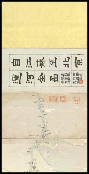
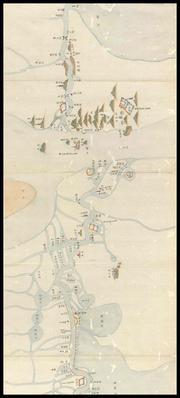
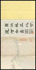
Русский: Изображение "Jiangsu zhi Beijing yun he quan tu" ("Вид всего канала, соединяющего Цзянсу с Пекином") выполнено на длинном сплошном листе бумаги, сложенном "гармошкой". "Гармошка" состоит из 21 листа, каждый высотой 24,1 см и шириной 13 см. Название в начале написано от руки чернилами официальным каллиграфическим почерком. Работа была напечатана в период правления династии Цин (1644–1911 гг.), но автор и дата публикации неизвестны. Надпись из трех строк слева указывает, что работа была приобретена в восьмой месяц года Гэнсюй (непрерывная система нумерации китайского календаря с циклом в 60 лет) и восстановлена в мастерской вблизи городских ворот. На документе имеются несколько оттисков печатей, среди них белая квадратная печать с фамилией Ду, красная квадратная печать с именем Фуань и еще одна белая печать с именем Ян Цзяньсинь. Эти печати, по всей вероятности, указывают предыдущих владельцев документа. Предметом изображения является Большой канал Пекин–Ханчжоу, известный как Большой канал, самый длинный в мире канал или искусственная река. Канал способствовал развитию экономического рынка в городских центрах Китая со времени правления династии Суй (581–618 гг.). Начиная с периода правления династии Тан до периода правления династии Цин, Большой канал являлся главной водной артерией, соединяющей северный и южный Китай, и был необходим для транспортировки зерна и других товаров в Пекин. Удобный водный путь позволял императорам возглавлять инспекционные поездки в южный Китай. Во времена правления династии Цин императоры Канси и Цяньлун совершили 12 поездок на юг, во всех случаях, кроме одного, достигнув Ханчжоу. Изображение повреждено в начале и в конце, кроме того, отсутствует изображение южной части нижнего течения реки Янцзы. На представленном изображении показан канал, начинающийся в Линкоу Чжэнь вблизи Вуцзинь Сянь, провинция Цзянсу, и протекающий на север до границы Линьцин Чжоу, провинция Шаньдун. На карте показано место пересечения канала с Желтой рекой, но не показано, где он достигает Пекина. Изображение выполнено со скрупулезной прорисовкой деталей с четким обозначением притоков, озер, гор, лесов, городов, мостов, монастырей, пагод, храмов, камерных шлюзов, набережных, песчаных берегов, шлюзовых ворот, а также расстояний между точками. Некоторые притоки изображены так плотно, что напоминают паутину. Такой тип печатной карты является большой редкостью.
Каналы; Большой канал (Китай); Реки; Река Янцзы (Китай) Français : Jiangsu zhi Beijing yun he quan tu (Vue détaillée du canal de Jiangsu à Pékin) est constituée d'une longue feuille de papier continue pliée en accordéon. Elle comporte 21 plis, chacun mesurant 24,1 centimètres de haut et 13 centimètres de large. Le titre au début est écrit à la main, à l'encre, et la calligraphie utilise le style de caractères officiel. L'ouvrage fut imprimé au cours de la dynastie Qing (1644–1911), mais l'auteur et la date de publication sont inconnus. L'inscription sur trois lignes à gauche indique que l'ouvrage fut acheté au cours du huitième mois de l'année de Gengxu (un système de numérotation continue du calendrier chinois suivant un cycle de 60 ans) et réparé dans un magasin près de la porte de la ville. On trouve également plusieurs sceaux imprimés, dont un sceau carré blanc où figure le nom de famille Du, un sceau carré rouge avec le nom Fu'an et autre sceau blanc avec le nom Yang Jianxin. Ces sceaux font certainement référence aux propriétaires antérieurs de l'ouvrage. Le sujet de cette peinture est le grand canal de Pékin à Hangzhou, connu sous le nom de Grand canal, qui constitue le plus long canal (ou rivière artificielle) au monde. Le canal favorisa le développement du marché économique des centres urbains chinois dès la période Sui (581–618). De la dynastie Tang jusqu'à la dynastie Qing, le Grand canal servait d'artère principale entre la Chine septentrionale et la Chine méridionale. Il était essentiel au transport de céréales et d'autres marchandises vers Pékin. Ce transport pratique permettait aussi aux empereurs de mener des tournées d'inspections en Chine méridionale. Au cours de la dynastie Qing, les empereurs Kangxi et Qianlong effectuèrent 12 voyages vers le sud, pour toutes sortes d'occasions, mais un seul jusqu'à Hangzhou. Cette peinture est abîmée à la fois devant et derrière, et il manque la section sud du cours inférieur du fleuve Yangtsé. On peut voir le début du canal à Lingkou Zhen, près de Wujin Xian, dans la province du Jiangsu. Il serpente ensuite vers le nord jusqu'à ce qu'il atteigne les frontières de Linqing Zhou, dans la province du Shandong. La carte montre l'endroit où le canal traverse le fleuve Jaune, mais pas son arrivée à Pékin. La peinture est réalisée de manière extrêmement détaillée et comporte des indications claires sur les affluents, les lacs, les montagnes, les forêts, les villes, les ponts, les monastères, les pagodes, les temples, les écluses, les quais, les bancs de sable, les vannes, ainsi que sur les distances entre les points. Certains des affluents sont représentés avec tant de précision qu'ils ressemblent à des toiles d'araignées. Ce type de carte imprimée est très rare.
Canaux; Grand canal (Chine); Rivières, fleuves et cours d'eau; Fleuve Yang-Tsé (Chine) English: Jiangsu zhi Beijing yun he quan tu (A complete view of the canal from Jiangsu to Beijing) is made of a long continuous sheet of paper folded into accordion-like leaves. It has 21 folds, each 24.1 centimeters high and 13 centimeters wide. The title at the beginning is handwritten in ink and the calligraphy is in the official script style. The work was printed in the Qing dynasty (1644–1911), but the author and the date of publication are unknown. The three-line inscription on the left indicates that the work was acquired in the eighth month of the year of Gengxu (a continuous numbering system on the Chinese calendar in a 60-year cycle) and repaired at a shop near the city gate. There are also several seal impressions, among them a white square seal with the surname Du, a red square seal with the name Fu’an, and another white seal with the name Yang Jianxin. These seals most likely identify earlier owners of the work. The subject of the painting is the Great Beijing–Hangzhou Canal, known as the Grand Canal, the longest canal or artificial river in the world. The canal furthered a growing economic market in China's urban centers ever since the Sui period (581–618). From the Tang to the Qing dynasties, the Grand Canal served as the main artery between northern and southern China and was essential for the transport of grain and other commodities to Beijing. Convenient transport also enabled the emperors to lead inspection tours to southern China. In the Qing Dynasty, the emperors Kangxi and Qianlong made 12 trips to the south, on all occasions but one reaching Hangzhou. This painting is damaged both at the front and at the end, and lacks the section south of the lower reaches of the Yangtze River. Shown here is the canal starting at Lingkou Zhen, near Wujin Xian, Jiangsu Province, and winding its way north until it reaches the boundary of Linqing Zhou, Shandong Province. The map shows where the canal crosses the Yellow River, but not where it reaches Beijing. The painting is executed in meticulous detail, with clear indications of tributaries, lakes, mountains, forests, cities, bridges, monasteries, pagodas, temples, canal locks, embankments, sandbanks, sluice gates, as well as distances between points. Some of the tributaries are depicted so densely that they resemble cobwebs. This kind of printed map is very rare.
Canals; Grand Canal (China); Rivers; Yangtze River (China) 中文:江苏至北京运河全图》由连续长页制成后折迭为经折装,高 24.1 厘米,宽 13 厘米,共 21 折。卷首附有以墨笔隶书手题的图名。此图于清代(1644–1911 年)刊印,但作者与出版日期未知。左下有三行题记云:“庚戌秋仲得此/图于都门厂肆/修整后题首”。图上还盖有多个章印,包括“杜”字白方、“复盦”朱方 以及“杨见心”白方,这些印章很可能指作品之前的收藏者。这幅地图以世界上最长的人工运河“京杭大运河”(简称“大运河”)为主题。自隋代 (581–618 年)以来,大运河促进了中国都市中心区经济市场的繁荣。从唐代至清代,它作为贯穿中国南北的主要交通动脉,一直是运输粮食和其它商品到北京的要道。这条便利的交通动脉也让皇帝得以巡视江南地区。在清代,康熙皇帝和乾隆皇帝就曾12 次南巡,有一次还到过杭州。本图首尾有残损,江南一段已佚缺。图中所示的运河不是自杭州起,而是自江苏武进县附近之陵口镇起始,一路蜿蜒北进,但只到山东省的临清州界止,才刚越黄河,尚未进入河北,距北京还有一段相当长的距离。这幅地图绘制精细,沿途各支流、湖泊、山林、城池、桥梁、寺院、宝塔、神庙、沟闸、河堤岸、沙洲、斗门,乃至各地距离等等,均一一注明。有些支流密如蛛网,是常年在运河上航行的漕运客难以想象的。这类地图向来较少刻本传世,因此非常珍贵。
运河; 大运河(中国); 河流; 长江(中国) Português: Jiangsu zhi Beijing yun he quan tu (Uma vista total do canal de Jiangsu a Pequim) é feito de uma longa folha contínua de papel dobrada em folhas em forma de sanfona. Ele tem 21 dobras, cada uma com 24,1 centímetros de altura e 13 centímetros de largura. O título no início é escrito à mão à tinta e a caligrafia é no estilo de escrita oficial. A obra foi impressa na dinastia Qing (1644-1911), mas o autor e a data de publicação são desconhecidos. A inscrição de três linhas à esquerda indica que a obra foi adquirida no oitavo mês do ano de Gengxu (um sistema de numeração contínua no calendário chinês em um ciclo de 60 anos) e reparado em uma loja perto do portão da cidade. Há também diversas impressões de selos, entre eles um selo quadrado branco com o sobrenome Du, um selo quadrado vermelho com o nome Fu'an e um outro selo branco com o nome Yang Jianxin. Estes selos muito provavelmente identificam os antigos proprietários do trabalho. O tema da pintura é o Grande Canal Jin-Han, conhecido como o Grande Canal, o maior canal ou rio artificial do mundo. O canal promoveu um crescente mercado econômico nos centros urbanos da China desde o período Sui (581–618). Da dinastia Tang à dinastia Qing, o Grande Canal serviu como a principal artéria entre o norte e o sul da China e foi essencial para o transporte de grãos e outros insumos para Pequim. O conveniente transporte também permitiu que os imperadores liderassem excursões de inspeção ao sul da China. Na Dinastia Qing, os imperadores Kangxi e Qianlong fizeram 12 viagens para o sul. Em todas as ocasiões, menos uma, chegaram a Hangzhou. Esta pintura está danificada tanto no início quanto no final, e falta a seção sul do curso inferior do rio Yangtzé. Este documento mostra o canal a partir de Lingkou Zhen, perto de Wujin Xian, província de Jiangsu, e seu caminho sinuoso para o norte, até atingir o limite de Linqing Zhou, província de Shandong. O mapa mostra onde o canal atravessa o rio Amarelo, mas não onde ele alcança Pequim. A pintura é executada em detalhes meticulosos, com indicações claras de afluentes, lagos, montanhas, florestas, cidades, pontes, mosteiros, pagodes, templos, eclusas, diques, restingas, comportas, bem como as distâncias entre os pontos. Alguns dos afluentes são retratados tão densamente que se assemelham a teias de aranha. Este tipo de mapa impresso é muito raro.
Canais; Grande Canal (China); Rios; Rio Yangtzé (China) العربية: إن لوحة Jiangsu zhi Beijing yun he quan tu (منظر شامل للقناة امتداداً من "جيانغسو" إلى "بيكين") مصنوعة من لوح طويل متواصل من الورق، تم طيه ليشبه طيات الأكورديون. يبلغ عدد طياتها 21 طية، طول كل منها 24,1 سنتيمتر وعرضها 13 سم. العنوان في المقدمة مكتوب بخط اليد باستخدام الحبر، وهو مرسوم بأسلوب كتابة الوثائق الرسمية. تمت طباعة هذا العمل في عهد أسرة تشينغ (1644 - 1911)، إلا أن هوية المؤلف وتاريخ النشر مجهولان حتى الآن. تشير الأسطر الثلاثة المنقوشة على اليسار إلى أنه قد تم الحصول على هذا العمل في الشهر الثامن من عام غنشي (نظام ترقيم متواصل على التقويم الصيني، في دورة تتكرر كل 60 عاماً) وأنه تم إصلاحها في متجر بالقرب من بوابة المدينة. كذلك توجد العديد من الأختام، من بينها ختم أبيض مربع، يحمل اسم عائلة "تو"، وختم أحمر مربع يحمل الاسم "فو آن" وختم آخر أبيض يحمل الاسم "يانغ جيانشين". من المرجح أن هذه الأختام تحدد هوية المالكين السابقين لهذا العمل. موضوع اللوحة هو قناة "بيكين" - "هانغتشو" الكبرى، والشهيرة بالقناة الكبرى، وهي أطول قناة أو نهر صناعي في العالم. ساعدت هذه القناة على نمو السوق الاقتصادي في مراكز الصين الحضرية منذ عهد "سوي" (581 - 618). منذ عهد أسرة تانغ وحتى أسرة تشينغ، كانت القناة الكبرى بمثابة شريان رئيسي يربط بين شمال الصين وجنوبها، ولعبت دوراً جوهرياً في نقل الحبوب وغيرها من البضائع إلى بيكين. كما مكَّنت سبل التنقل المريحة الأباطرة من القيام بجولات تفتيشية إلى جنوب الصين. قام اثنان من أباطرة عهد أسرة تشينغ، وهما كانغشي وتشينلونغ باثنتي عشرة رحلة إلى الجنوب، وصلت جميعها إلى هانغتشو، فيما عدا واحدة. تعرضت هذه اللوحة للتلف في مقدمتها ونهايتها، وينقصها الجزء الجنوبي من التفرعات السفلية لنهر يانغتسي. تظهر هنا القناة بدءاً من لينغكاو تشين، بالقرب من ووجينغشيان بمقاطعة جيانغسو، ثم تلتف متجهة إلى الشمال حتى تصل إلى حدود "لينتشينغ تشو"، في مقاطعة شاندونغ. تُظهر الخريطة مكان تقاطع القناة مع النهر الأصفر، ولكنها لا تُظهر نقطة انتهائها في "بيكين". رُسمت اللوحة بتفصيل دقيق، وبإشارات واضحة إلى الروافد والبحيرات والجبال والغابات والمدن والجسور والأديرة والهياكل والمعابد والأهوسة والسدود والأرصفة الرملية وحواجز التحكم في المياه، كما توضح كذلك المسافات بين كل نقطة وأخرى. رُسمَت بعض الروافد بشكل متشابك حتى تكاد تشبه شبكة العنكبوت. هذا النوع من الخرائط المطبوعة يعد نادراً للغاية.
القنوات; القناة الكبرى (الصين); الأنهار; نهر يانغتسي (الصين) Español: Jiangsu zhi Beijing yun he quan tu (Una vista completa del canal desde Jiangsu hasta Pekín) se compone de una larga hoja continua de papel plegada en hojas tipo acordeón. Tiene 21 pliegues, cada uno de 24,1 centímetros de alto y 13 centímetros de ancho. El título al comienzo está manuscrito en tinta y la caligrafía se encuentra en el estilo oficial de escritura. La obra se publicó durante la dinastía Qing (1644-1911), aunque se desconocen el autor y la fecha de publicación. La inscripción de tres renglones a la izquierda indica que la obra se obtuvo en el octavo mes del año de Gengxu (un sistema de numeración continua en el calendario chino dentro de un ciclo de 60 años) y se reparó en una tienda cerca de la puerta de la ciudad. También se observan varias impresiones de sellos, entre las cuales se encuentran un sello blanco cuadrado con el apellido Du, un sello cuadrado rojo con el nombre Fu’an y otro sello blanco con el nombre Yang Jianxin. Lo más probable es que estos sellos identifiquen a los anteriores dueños de la obra. El tema de la pintura es el Gran Canal Pekín–Hangzhou, también conocido como el Gran Canal, el canal o río artificial más largo del mundo. El canal fomentó el mercado económico en crecimiento en los centros urbanos de China desde el período Sui (581–618). Desde la dinastía Tang hasta la Qing, el Gran Canal funcionó como la arteria principal entre el norte y el sur de China y fue esencial para el transporte de granos y otras mercancías a Pekín. El conveniente transporte también permitió que los emperadores lideraran viajes de inspección al sur de China. Durante la dinastía Qing, los emperadores Kangxi y Qianlong hicieron 12 viajes al sur y, en todos menos uno, llegaron a Hangzhou. La pintura está dañada tanto en el frente como al final, y le falta la sección sur del curso bajo del río Yangtsé. Aquí se muestra el canal que comienza en Lingkou Zen, cerca de Wujin Xian, provincia de Jiangsu, y se serpentea hacia el norte hasta llegar al límite con Linqing Zhou, provincia de Shandong. El mapa muestra el lugar donde el canal cruza el río Amarillo, pero no donde llega a Pekín. La pintura se ejecutó con detalles meticulosos e indicaciones claras de afluentes, lagos, montañas, bosques, ciudades, puentes, monasterios, pagodas, templos, esclusas, diques, bancos de arena, compuertas y las distancias entre los puntos. Algunos de los afluentes se representaron con tanta densidad que se asemejan a telarañas. Esta clase de mapa impreso es muy inusual.
Canales; Gran Canal (China); Ríos; Río Yangtsé (China) |
| Date | between 1644 and 1911 |
| Medium |
Русский: Книги
Français : Livres
English: Books
中文:图书
Português: Livros
العربية: كتب
Español: Libros |
| Dimensions |
English: 1 volume |
| Collection |
Русский: Национальная центральная библиотека
Français : Bibliothèque centrale nationale
English: National Central Library
中文:国立中央图书馆
Português: Biblioteca Nacional Central
العربية: المكتبة المركزية الوطنية
Español: Biblioteca Nacional Central |
| Place of creation |
Русский: Пекин
Français : Pékin
English: Beijing
中文:北京
Português: Pequim
العربية: بكين
Español: Pekín |
| Notes | Original language title: 江蘇至北京運河全圖 |
| Source/Photographer |
http://dl.wdl.org/7097/service/7097.pdf
|
Licensing[edit]
|
This is a faithful photographic reproduction of a two-dimensional, public domain work of art. The work of art itself is in the public domain for the following reason:
The official position taken by the Wikimedia Foundation is that "faithful reproductions of two-dimensional public domain works of art are public domain".
This photographic reproduction is therefore also considered to be in the public domain in the United States. In other jurisdictions, re-use of this content may be restricted; see Reuse of PD-Art photographs for details. | ||||
File history
Click on a date/time to view the file as it appeared at that time.
| Date/Time | Thumbnail | Dimensions | User | Comment | |
|---|---|---|---|---|---|
| current | 03:23, 3 March 2014 | 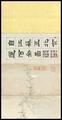 | 900 × 1,747, 13 pages (2.88 MB) | Fæ (talk | contribs) | =={{int:filedesc}}== {{Artwork |artist = |author = |title ={{ru|1=Вид всего канала, соединяющего Цзянсу с Пекином}} {{fr|1=Vue détaillée du canal de Jiangsu à Pékin}} {{en|1=A Complete View of the Canal from... |
You cannot overwrite this file.
File usage on Commons
The following page uses this file: