File:A Complete Geographic Atlas of East Section of Yansui County WDL7096.pdf
Jump to navigation
Jump to search
Size of this JPG preview of this PDF file: 333 × 599 pixels. Other resolutions: 133 × 240 pixels | 267 × 480 pixels | 900 × 1,618 pixels.
Original file (900 × 1,618 pixels, file size: 2.58 MB, MIME type: application/pdf, 16 pages)
Captions
Captions
Add a one-line explanation of what this file represents
Summary[edit]
| Title |
Русский: Полный географический атлас восточного района округа Яньсуй
Français : Atlas géographique complet de la section est du comté de Yansui
English: A Complete Geographic Atlas of East Section of Yansui County
中文:延绥东路地里图本
Português: Um atlas geográfico completo da seção leste do condado de Yansui
العربية: أطلس جغرافي كامل عن الجزء الجنوبي من مقاطعة يانسو
Español: Un atlas geográfico completo de la sección este del condado de Yansui |
| Description |
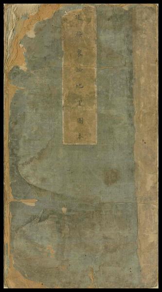
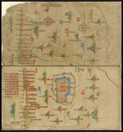
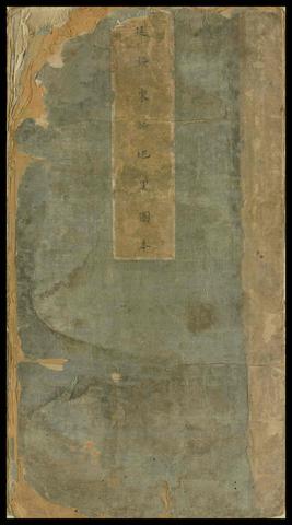
Русский: Эта книга, состоящая из сложенных "гармошкой" листов, представляет собой военную карту, выполненную краской по шелку, изображающую военную крепость Яньсуй Чжэнь в северной провинции Шэньси. Книга большого формата высотой 48,3 см и шириной 25,5 см имеет 14 складных листов. В наклейке на крышке переплета указано название "Yan sui dong lu di li tu ben" ("Полный географический атлас восточного района округа Яньсуй"). Округ имел 36 крепостей, но в этой работе изображены только 11 из них: Циншуй Ин, Мугуа Юань, Гушань, Чжэньцян, Юнсин, Шэньму, Дабайю, Байлинь, Гаоцзя, Цзюаньань и Шуаншань. Изображения остальных крепостей округа, в том числе Хуанфучуань Бао и 24 других, отсутствуют. На цветных иллюстрациях изображены горы, города с крепостными стенами, реки и крепости без какого-либо сопроводительного текста. Географические названия написаны от руки на отрезках тонкой коричневой бумаги, которые наклеены в книгу. Многие верхние поля содержат надписи, указывающие, что изображенные территории были недоступны. Составленный с использованием искусных высокопрофессиональных методов, атлас является одной из редчайших военных карт периода династии Мин (1368-1644 гг.). Автор и точная дата опубликования неизвестны.
География; Военные карты Français : Ce livre en forme d'accordéon est une carte militaire peinte en couleur sur soie, montrant Yansui Zhen, une forteresse militaire dans la province septentrionale du Shaanxi. L'ouvrage est long et large, puisqu'il mesure 48,3 centimètres de haut et 25,5 centimètres de large, en 14 plis. Une étiquette sur la couverture indique le titre, Yan sui dong lu di li tu ben (Atlas géographique complet de la section est du comté de Yansui). Le comté possédait 36 forteresses, mais seules 11 d'entre elles sont représentées dans cet ouvrage : Qingshui Ying, Mugua Yuan, Gushan, Zhenqiang, Yongxing, Shenmu, Dabaiyou, Bailin, Gaojia, Jian’an et Shuangshan. Les autres forteresses du comté, notamment Huangfuchuan Bao et 24 autres, sont absentes. Les illustrations couleur montrent des montagnes, des villes fortifiées, des rivières et des forteresses, mais ne sont accompagnées d'aucun texte. Les noms de lieux sont écrits à la main sur des morceaux de fin papier brun, collés sur le livre. De nombreuses marges supérieures contiennent des mots indiquant que les lieux montrés sont inaccessibles. Réalisé à l'aide de techniques expertes et raffinées, l'atlas est l'une des cartes militaires les plus rares de la dynastie Ming. L'auteur et la date exacte de publication sont inconnus.
Géographie; Cartes militaires English: This accordion-shaped book is a military map painted in color on silk, depicting Yansui Zhen, a military fortress in northern Shaanxi province. The work is long and wide, measuring 48.3 centimeters high and 25.5 centimeters wide, in 14 folds. A label on the cover gives the title, Yan sui dong lu di li tu ben (A complete geographic atlas of the east section of Yansui County). The county had 36 fortresses, but only 11 of them are depicted in this work: Qingshui Ying, Mugua Yuan, Gushan, Zhenqiang, Yongxing, Shenmu, Dabaiyou, Bailin, Gaojia, Jian’an, and Shuangshan. The rest of county’s fortresses, including Huangfuchuan Bao and the 24 others, are missing. The color illustrations depict mountains, walled cities, rivers, and fortresses, with no texts attached. Place-names are hand-written on pieces of fine brown paper, which are glued into the book. Many of the top margins contain words indicating that the places shown were inaccessible. Produced with skilled and refined technique, the atlas is one of the rarest military maps of the Ming dynasty (1368–1644). The author and the exact date of publication are unknown.
Geography; Military maps 中文:此书为经折装,是绢本彩绘的军事地图,描绘的是明代中叶以后陕北延绥镇的军事要塞。地图版式宽大,高 48.3 厘米,宽 25.5 厘米,共 14 折。封面上的书签题有 [延绥东路地里图本] 几个大字,是这幅地图的标题。整个延绥镇共有 36 个堡,这幅地图仅描绘了 11 个,包括:清水营、木瓜园、孤山、镇羌、永兴、神木、大栢油、栢林、高家、建安、双山。卷首尚缺黄甫川堡以及另外 24 个要塞未记录在内。图中使用彩色插图描绘了山川、城镇、河流、堡寨,但无文字介绍。地名则是以褐色细纸上手写,然后黏贴上去的。顶部边缘大多标注的是形胜险要之地。此图以丝绢及精良的技巧制成,为极难得一见的明代(1368–1644 年)军事地图善本。作者及具体出版时间未知。
地理学; 军事地图 Português: Este livro em forma de sanfona é um mapa militar pintado com cores sobre seda, retratando Yansui Zhen, uma fortaleza militar no norte da província de Shaanxi. O trabalho é comprido e largo, medindo 48,3 centímetros de altura e 25,5 centímetros de largura, com 14 dobras. Uma etiqueta na capa fornece o título, Yan sui dong lu di li tu ben (Um atlas geográfico completo da seção leste do condado de Yansui). O condado possuía 36 fortalezas, mas apenas 11 delas são retratadas nesta obra: Qingshui Ying, Mugua Yuan, Gushan, Zhenqiang, Yongxing, Shenmu, Dabaiyou, Bailin, Gaojia, Jian’an e Shuangshan. O restante das fortalezas do condado, incluindo Huangfuchuan Bao e 24 outras, estão faltando. As ilustrações coloridas retratam montanhas, cidades muradas, rios e fortalezas, sem textos anexados. Os nomes das localidades estão escritos à mão em pedaços de papel marrom fino, que estão colados no livro. Muitas das margens superiores contêm palavras indicando que os lugares mostrados eram inacessíveis. Produzidos com técnica qualificada e refinada, o atlas é um dos mais raros mapas militares da dinastia Ming (1368-1644). O autor e a data exata da publicação são desconhecidos.
Geografia; Mapas militares العربية: يصور الكتاب الشبيه بالأكورديون حصن يانسو جين وهو حصن عسكري في شمال إقليم شنشي، والكتاب عبارة عن خريطة عسكرية ملونة مرسومة على قماشٍ حريري. ويتميز هذا الكتاب بكِبَر حجمه حيث تبلغ أبعاده 48.3 سنتيمتر ارتفاعاً و25.5 سنتيمتر عرضاً وتبلغ عدد طياته 14 طية. وتوجد لاصقة على الكتاب توضح عنوانه، Yan sui dong lu di li tu ben (أطلس جغرافي كامل عن الجزء الجنوبي من مقاطعة يانسو). تكونت المقاطعة من 36 حصناً، تم وصف 11 منها فقط في هذا العمل وهي: سينغ شواي ينغ، موغوا يوان، غوشن، زنشيانغ، يونغ شينغ، شنمو، دابايو، بايلين، جاوشيا، شيان أن، وشوانغ شين. أما بقية حصون المقاطعة بما فيها هوانغ فوتشوان باو والـ24 حصناً الأخرى فغير موجودة بالكتاب. تم وصف الجبال والمدن ذات الأسوار والأنهار والحصون باستخدام الألوان فقط دون كتابة أي نص. وقام المؤلف بكتابة أسماء الأماكن بخط اليد على قطعٍ من ورقٍ بني فاخر ولصقها بالكتاب. وتحتوي العديد من الهوامش العُليا على كلماتٍ تشير إلى أن الأماكن الموضحة تَعَذَر الوصول إليها. تُعد خرائط الأطلس مجموعةً من أكثر الخرائط العسكرية نُدرة لعهد أسرة مينغ (1368–1644) وتدل على أن المؤلف قد قام بجمعه بمهارة. لم يتم التعرف على المؤلف وتاريخ النشر بالضبط.
الجغرافيا; الخرائط الحربية Español: Este libro en forma de acordeón es un mapa militar pintado a color sobre seda, en el que se representa Yansui Zhen, un fuerte militar al norte de la provincia de Shaanxi. La obra es larga y ancha: mide 48,3 centímetros de alto y 25,5 centímetros de ancho, en 14 pliegues. El título se ofrece en una etiqueta en la tapa, Yan sui dong lu di li tu ben (Un atlas geográfico completo de la sección este del condado de Yansui). El condado tenía 36 fuertes, aunque solo 11 se muestran en esta obra: Qingshui Ying, Mugua Yuan, Gushan, Zhenqiang, Yongxing, Shenmu, Dabaiyou, Bailin, Gaojia, Jian’an y Shuangshan. No se muestra el resto de las fortalezas del condado, que incluyen a Huangfuchuan Bao y las 24 restantes. Las ilustraciones a color muestran montañas, ciudades amuralladas, ríos y fortalezas, sin textos adjuntos. Los topónimos están manuscritos en trozos de papel marrón fino, que están pegados al libro. Muchos de los márgenes superiores tienen palabras que indican que los lugares presentados eran inaccesibles. El atlas, producido con una técnica hábil y refinada, es uno de los más inusuales mapas militares de la dinastía Ming (1368–1644). Se desconocen el autor y la fecha exacta de publicación.
Geografía; Mapas militares |
| Date | between 1368 and 1644 |
| Medium |
Русский: Книги
Français : Livres
English: Books
中文:图书
Português: Livros
العربية: كتب
Español: Libros |
| Dimensions |
English: 1 volume |
| Collection |
Русский: Национальная центральная библиотека
Français : Bibliothèque centrale nationale
English: National Central Library
中文:国立中央图书馆
Português: Biblioteca Nacional Central
العربية: المكتبة المركزية الوطنية
Español: Biblioteca Nacional Central |
| Place of creation |
Русский: Провинция Шэньси
Français : Province du Shaanxi
English: Shaanxi Province
中文:陕西省
Português: Província de Shaanxi
العربية: مقاطعة شنشي
Español: Provincia de Shaanxi |
| Notes |
Original language title: 延綏東路地理圖本 Русский: Сложенные "гармошкой" листы
Français : Plié en accordéon
English: Folded in accordian style
中文:经折装
Português: Dobrado no estilo sanfona
العربية: مطوي على هيئة أكورديون
Español: Plegado al estilo acordeón |
| Source/Photographer |
http://dl.wdl.org/7096/service/7096.pdf
|
Licensing[edit]
|
This is a faithful photographic reproduction of a two-dimensional, public domain work of art. The work of art itself is in the public domain for the following reason:
The official position taken by the Wikimedia Foundation is that "faithful reproductions of two-dimensional public domain works of art are public domain".
This photographic reproduction is therefore also considered to be in the public domain in the United States. In other jurisdictions, re-use of this content may be restricted; see Reuse of PD-Art photographs for details. | ||||
File history
Click on a date/time to view the file as it appeared at that time.
| Date/Time | Thumbnail | Dimensions | User | Comment | |
|---|---|---|---|---|---|
| current | 03:22, 3 March 2014 |  | 900 × 1,618, 16 pages (2.58 MB) | Fæ (talk | contribs) | =={{int:filedesc}}== {{Artwork |artist = |author = |title ={{ru|1=Полный географический атлас восточного района округа Яньсуй}} {{fr|1=Atlas géographique complet de la section est du comté de Yansu... |
You cannot overwrite this file.
File usage on Commons
The following page uses this file: